By Jay Landers
California’s State Route 37 is a key east-west transportation link in the state’s North Bay Region, a subregion of the San Francisco Bay Area. The route is a low-lying, flood-prone highway that is expected to experience even more flooding as a result of anticipated future sea level rise. Against this backdrop, the California Department of Transportation and its local partners are assessing possible measures for protecting SR 37 against high water in the near future as well as in the long term. Although the potential solutions are in their early phases, initial estimates place their costs as ranging from hundreds of millions of dollars in the near term up to several billion dollars in the long term.
Heavily traveled
SR 37 extends for 21 mi, from U.S. 101 in the city of Novato in the west to Interstate 80 in the city of Vallejo to the east (see map). Along the way, the highway traverses the counties of Marin, Sonoma, Napa, and Solano. Much of the roadway passes through highly sensitive tidal marshland along the northern edge of the San Pablo Bay.
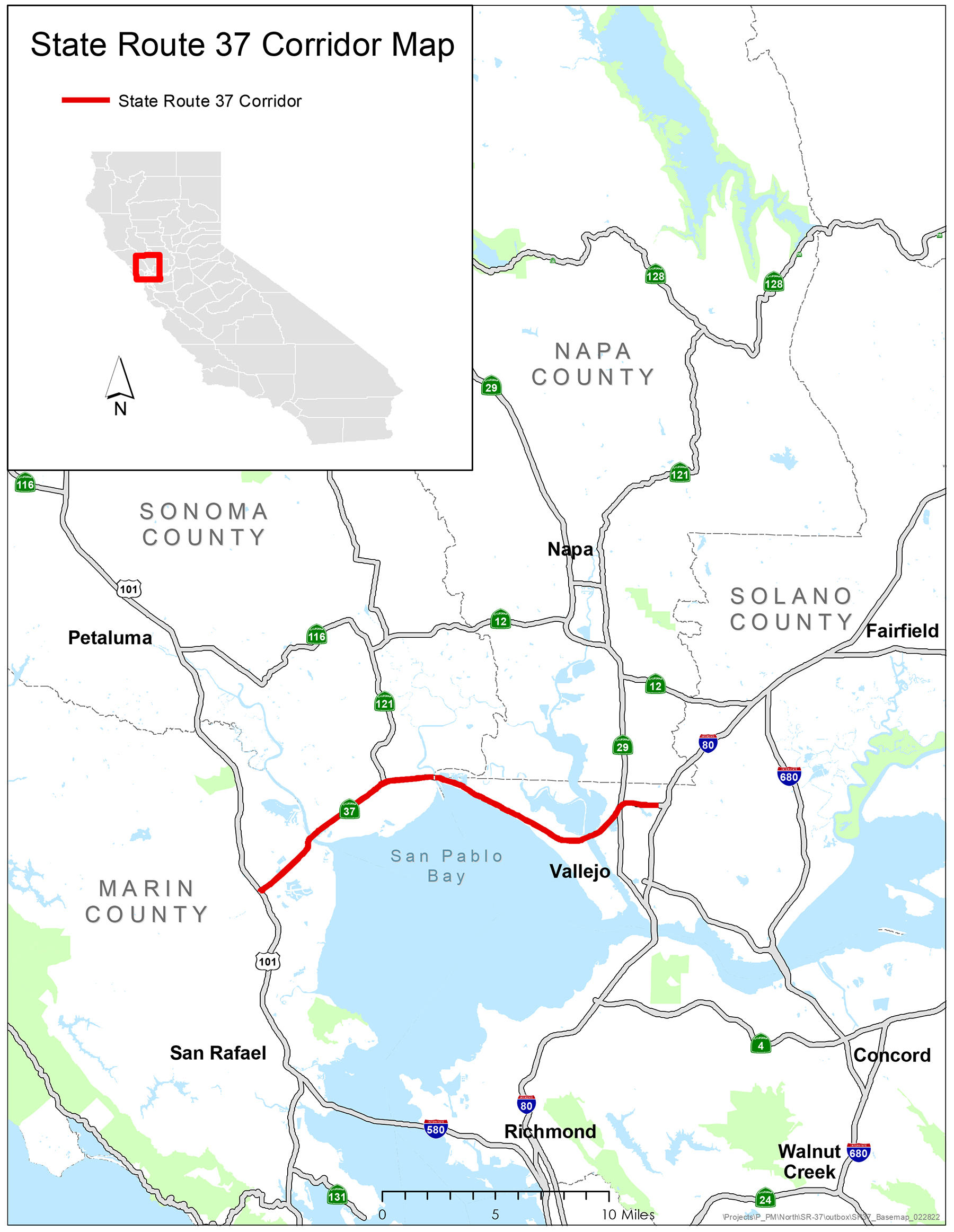
The heavily traveled highway frequently experiences congestion during daily commute hours on weekdays as well as on weekends, when travelers use it to head to and from the wine country in Napa and Sonoma counties. The fact that SR 37 narrows from four to two lanes along a 10 mi stretch of its eastern half exacerbates the congestion.
Recent flooding
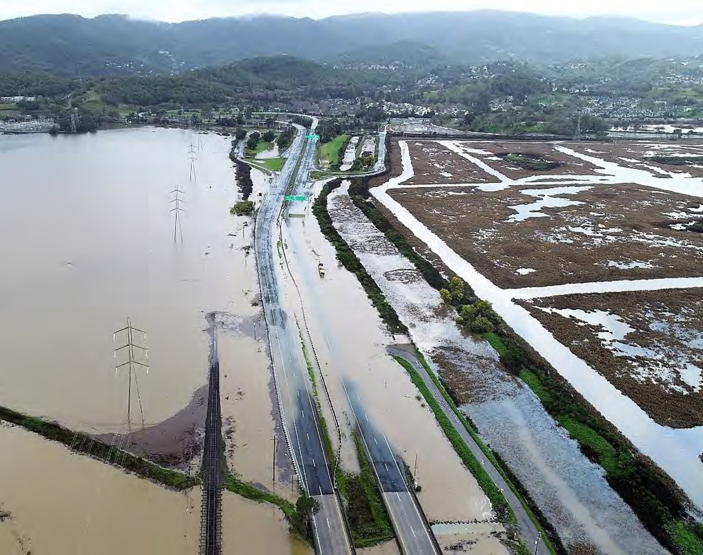
Given its low elevation and proximity to several tidally influenced waterways, SR 37 is prone to flooding, particularly along its western segments in Marin and Sonoma counties, where the roadway has elevations as low as 1.5 ft to 2 ft above sea level. Flooding is especially likely to occur when strong storm events coincide with high-tide conditions.
“This area is particularly vulnerable to near-term flooding and future sea level rise,” says Rui (Ricky) Gao, P.E., P.M.P, Caltrans’ regional project manager for SR 37. Indeed, SR 37 was closed for 28 days in 2017 and for eight days in 2019 as a result of flooding caused by the failure of one of several levees located near the highway. Closure of SR 37 forces travelers to make significantly longer trips on other local roads, increasing regional congestion.
In response to the flood events, Caltrans implemented such emergency measures as deploying temporary flood walls, raising pavement levels, improving drainage, and restoring levees located in the state right of way, Gao says. During the 2019 event, Caltrans also used tractor-based pumps to alleviate roadway flooding, a tactic that Caltrans’ maintenance crews are prepared to use again if necessary, Gao says.
What protection the levees continue to afford SR 37 cannot be counted on to last far into the future, however. “Right now, SR 37 relies on a complex and interconnected system of private and public levees,” Gao notes. “Recent studies and subsequent field surveys confirmed six potential low spots in the existing levee system.”
Eventual inundation
Although Caltrans has succeeded in preventing flooding of SR 37 since 2019, the long-term outlook for the roadway is grim. As sea level rise occurs, flooding associated with storm surges is expected to intensify, Gao says.
For modeling purposes, Caltrans relies on sea level rise projections from California’s Ocean Protection Council. According to the OPC, sea levels in the San Francisco area are expected to rise from 0.5 ft to 1 ft by 2030, 1.1 ft to 2.7 ft by 2050, and 3.4 ft to 10.2 ft by 2100.
Today, storm-surge flooding from a 25-year coastal storm event can be expected to cause flooding on certain locations of SR 37, Gao says. By 2030, storm-surge flooding from just a five- to 10-year coastal storm event is expected to cause flooding along these same locations on the roadway.
Even more significantly, unless modifications are made to SR 37, its western and middle segments are expected to be permanently under water as a result of sea level rise by 2050, Gao says. Eventually, even the higher-elevation eastern segment will succumb to sea level rise. “In general, all segments of the highway will be impacted by permanent inundation” by 2100, he says.
Near-term solutions
Fortunately, Caltrans and its local partners have time to devise solutions to address the looming problem of sea level rise. To this end, they are approaching the task with one eye on near-term flooding solutions for the most flood-prone section of SR 37 and the other on longer-term approaches for the entire length of the highway corridor.
To address flood threats in the near term, Caltrans has begun the initial phases of the SR 37 Flood Reduction Project, an effort focused on the 7.5 mi long stretch between U.S. 101 and SR 121 in Marin and Sonoma counties. “That project will reduce the risk of flooding along the portion of the corridor through the middle of the 21st century until a long-term solution can be constructed,” Gao says.
The preliminary range of alternatives under consideration include replacing bridges to higher elevations and raising the roadway profile by a combination of a viaduct, embankment, and flood wall. Based on initial cost estimates, the project could cost up to $520 million in current-year dollars.
An ongoing environmental phase study for the project is expected to be completed by spring 2023, Gao says. Construction is scheduled to begin in 2027, he notes, though this time frame depends on a host of factors, including funding availability and the completion of design, right-of-way acquisition, and environmental mitigation.
Longer-term solutions
Ultimately, Caltrans and its local partners — the Metropolitan Transportation Commission, the Transportation Authority of Marin, the Napa Valley Transportation Authority, the Sonoma County Transportation Authority, and the Solano Transportation Authority — aim to revamp the entirety of SR 37, from U.S. 101 all the way to I-80. In so doing, the goal is to protect the highway from the even greater sea level rise that is anticipated to occur by 2100. At the same time, the project is intended to provide corridorwide benefits, including ecological connectivity, multimodal improvements, increased public access, and greater social equity.
In late 2020, the groups began a comprehensive assessment, known as a Planning and Environmental Linkages Study, that is to be completed later this year. “The goal for the PEL Study is to collaborate with key resource agencies, stakeholders, and the public to identify and narrow the range of alternatives to be advanced for environmental review and potential construction,” Gao says.
In terms of addressing sea level rise, Caltrans and its partners are considering three main adaptation strategies, individually known as “protect, accommodate, and retreat,” Gao notes.
Under the protect strategy, a “system of engineered levees” would be constructed to defend SR 37 from the anticipated sea level rise and storm surge, Gao says. With the accommodate strategy, SR 37 would be “reconstructed by raising the highway to the design sea-level-rise elevation within the hazard area.” Finally, the retreat strategy would involve rerouting SR 37 “via proposed alignments north of existing SR 37,” he says.
Although still early in the planning stages, the longer-term project could cost more than $8 billion in today’s dollars, Gao says. “We’re still trying to identify the funding sources,” he says. “But we expect it will be a combination of federal, state, and regional funds.”