By Jay Landers
After more than a decade of construction, the nearly 19 billion British pound (about $24 billion) Elizabeth line in southeast England officially opened last week. Originally known as Crossrail, the 118 km railway project includes an underground section through central London that required the construction of 21 km of twin-bore tunnels and 10 new stations.
Before beginning the colossal earthmoving work associated with the construction of the central London section, Crossrail Ltd. — a wholly owned subsidiary of Transport for London formed to construct the project — had set an ambitious goal to dispose of the excavated material as sustainably as possible. Ultimately, almost all the 7 million metric tons of material was reused or recycled. Of this amount, nearly half was shipped to Wallasea Island, the site of a former farm on the Essex coast, and used to create a 165 ha area comprising multiple intertidal habitats.
The project, which laid the groundwork for what has become a highly successful 700 ha nature reserve owned and operated by the Royal Society for the Protection of Birds, aims to ensure that increasingly rare intertidal habitats along the English coast can be maintained in the face of rising sea levels resulting from climate change.
A farm below sea level
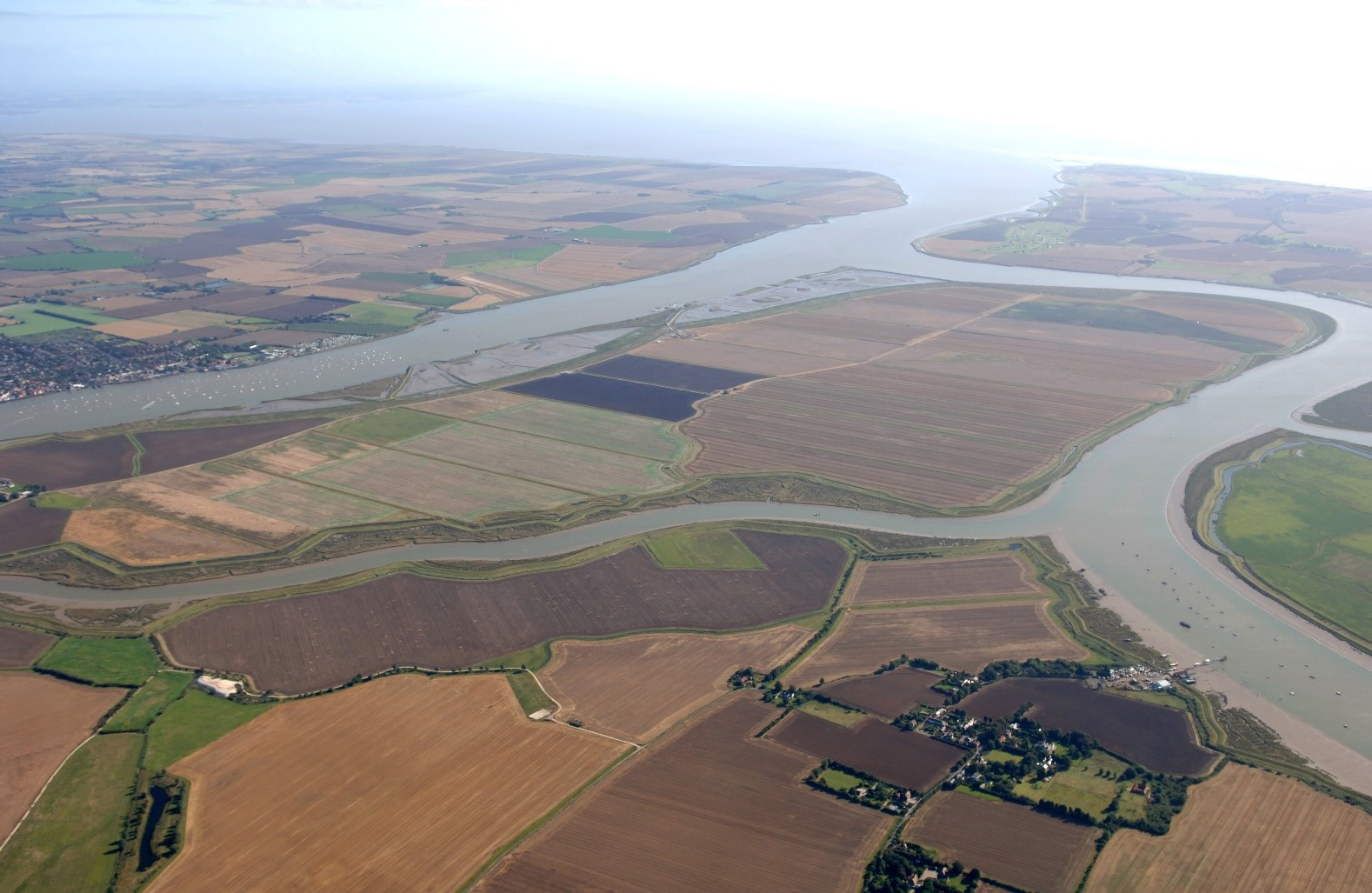
Wallasea Island is at the confluence of the rivers Crouch and Roach, near where the River Crouch enters the North Sea. Originally salt marsh and grassland, Wallasea Island was gradually enclosed with earthen sea walls during the course of a few hundred years to provide pasture for grazing sheep and a small amount of arable land, says Rachel Fancy, the site manager for the RSPB. The island also was home to a small number of inhabitants.
In the 1950s, a company purchased the island, flattening the land and digging straight-line drainage ditches to form fields for intensive farming. The island remained in this state until 2005, when its northern portion was restored to a more natural condition as part of a mitigation project intended to offset the loss of mudflats resulting from development elsewhere along the English coast.
The aging nature of the island’s sea walls helped convince the farming company to sell its property to the RSPB, Fancy says. “The sea walls were in danger of breaching in an unmanaged way,” she says. Because Wallasea Island is below sea level, such an event would have been catastrophic for the farming operations, as all crops would have been swamped with saline water.
Desired habitats
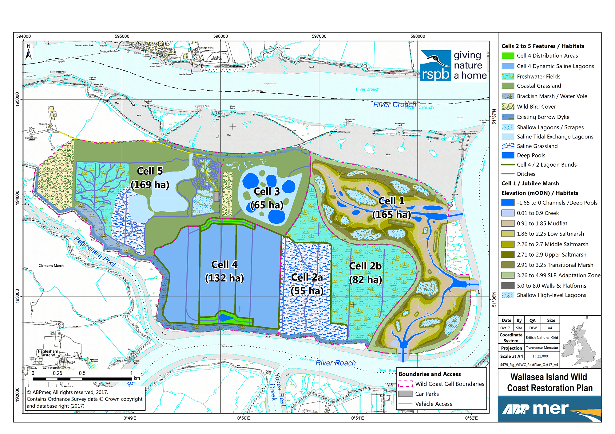
In 2008, Crossrail and the RSPB entered into an agreement under which Crossrail would deliver up to 4 million metric tons of material excavated during project construction to Wallasea Island. The material would be used to recontour a 165 ha section, known as cell 1, on the island’s eastern end (see restoration plan).
The island’s low-lying elevation is what necessitated the use of so much excavated material to restore the landscape to a more natural state, Fancy says. A key part of this plan involved breaching the sea wall in various locations to allow the tide to enter the site. However, doing so without raising the elevation would simply have swamped Wallasea Island much of the time. “If you just make holes in the sea wall and the water comes in, you don’t get any variation in the habitat,” she says. “You would just get a huge quantity of seawater coming in and out on each tide.”
In fact, modeling indicated that an unmanaged breach of the island’s sea walls would allow as much as 11 million cu m of seawater to flow through the site and enter the adjacent rivers, upsetting their estuarine conditions. However, using the excavated material to raise the site’s elevation would limit the inflow of seawater to 2 million cu m, an amount compatible with the estuary.
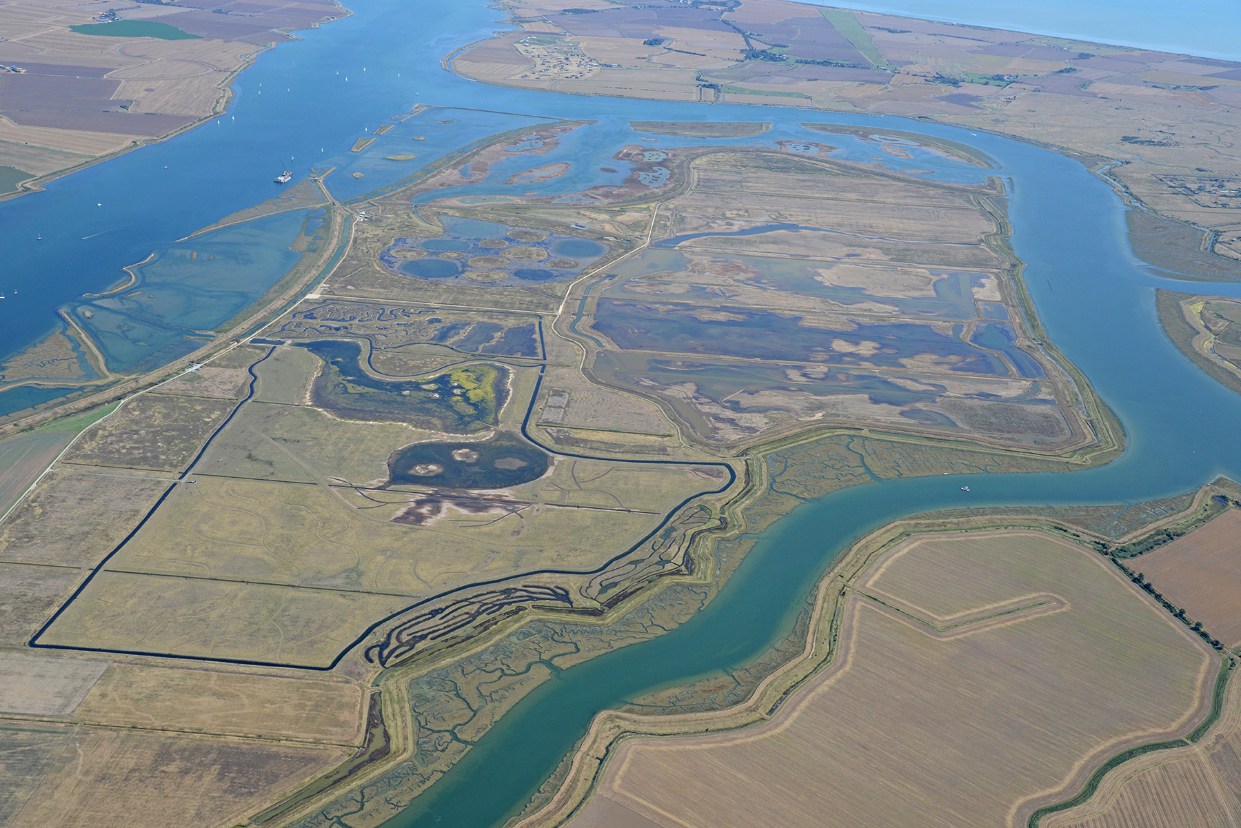
Having the material also enabled the RSPB to create a range of desired wildlife habitats at the site. “We could place that material exactly how we wanted, so we could get the full range of heights of land from grass down to salt marsh, middle salt marsh, lower salt marsh, mudflats, and channels,” Fancy says.
Such habitats are increasingly needed to offset losses from past development. “There’s been huge declines along the east coast of England both in salt marsh and mudflats,” Fancy says. “It’s only going to get worse because of sea level rise.” Instead of salt marshes, sea embankments line much of the Essex coast today. Indeed, salt marshes that do exist in front of sea embankments are expected to be overrun by rising sea levels, rather than migrating to higher elevations, Fancy says. “There’s nowhere for that salt marsh to go because there’s a sea wall in the way.”
1,528 shipments
The Crossrail project entered its main construction phase in 2011. Tunneling began the following year and entailed the use of eight tunnel boring machines. Other excavation work was conducted as part of the construction of stations, platform tunnels, shafts, and portals. All told, Crossrail excavated 7 million metric tons of material, 98% of which was reused or recycled, says Lorna Mellings, a former environmental manager for Crossrail who is now the head of environment for the Clancy Group Ltd.
Between August 2012 and April 2015, approximately 3.2 million metric tons of the material was sent to Wallasea Island, Mellings says. In general, this material consisted of clay, a soil type naturally present at the island.
Upon verification that it did not contain pollutants, the material either was transported by truck or rail to a dock, where it was loaded onto ships by conveyors. From there, the ships moved down the River Thames and into the North Sea, traveling approximately 120 km before reaching a pontoon dock at Wallasea Island. All told, 1,528 shipments were required to transport the material, Mellings says. Excavated material that was not sent to Wallasea Island was used for agricultural land and recreational facilities, Mellings says.
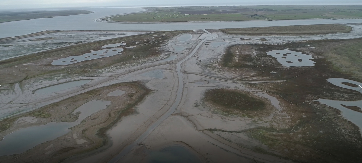
At the island, the material was removed from the ships, placed on a conveyor, and transported to a storage site. Dump trucks were used to haul the material to the intended locations on the island, grading equipment was used to achieve the slopes and elevations needed for the intended intertidal habitats, and rollers were used to compact the embankments. In July 2015, the sea wall was breached in three locations along cell 1, restoring tidal flows to that section of Wallasea Island.
The RSPB oversaw the project design. AECOM conducted 3D modeling of the area within cell 1, while ABPmer served as the marine environmental adviser on the project. Halcrow, which is now part of Jacobs, designed the sluice structures that were added to the sea wall along cell 1 and confirmed the final grading elevations. BAM Nuttal served as the general contractor on the project.
Definite success
In cell 1, which is now known as Jubilee Marsh, the project was designed with shallow slopes and other features to enable the low-lying habitats to relocate to higher ground in the future, Fancy says. “One of the things that we wanted to do is to make sure that the habitats had somewhere to go when sea levels rise.”
In another nod to climate change, the design of the overall nature reserve at Wallasea Island accounted for the likelihood that certain bird species would visit the site more frequently in the future. “There was some thought into what bird species might move into the area from Europe” as temperatures and rainfall levels change, Fancy says. For example, scrub habitat was planted in certain locations to provide nesting areas for Eurasian spoonbills (Platalea leucorodia).
Besides Jubilee Marsh, four other cells constitute the nature reserve at Wallasea Island. Completed in 2015, the 65 ha cell 3 is hydraulically linked to cell 1 by means of a sluice structure and includes a mix of deep pools, shallow lagoons, coastal grassland, and wild bird cover. Located to the west of cell 3, the 169 ha cell 5 was completed in 2016. It includes shallow lagoons, saline grassland, coastal grassland, wild bird cover, and brackish marsh.
Completed in 2018, cells 2 and 4 are hydraulically connected to the River Roach. The 137 ha cell 2 consists mainly of saline grassland and freshwater fields, while the 132 ha cell 4 comprises saline lagoons.
The intervening years have shown the overall project to be a definite success. “We now have across the reserve as a whole huge numbers of wintering birds, which is one of the things this area is important for,” Fancy says. For example, the bar-tailed godwit (Limosa lapponica) and the grey plover (Pluvialis squatarola) occur in “nationally significant numbers,” she says. However, wintering birds are not the only ones to take advantage of Wallasea Island. “In summer, we now have what we think is the largest colony of breeding avocets (Recurvirostra avosetta) in England,” she says.