The Eastern Glades project in Houston has added a new artificial lake and other amenities to the city’s Memorial Park. As a highlight of the park’s 10-year master plan, the multifunction Hines Lake provides the local community with stormwater treatment, flood control protection, aquatic wildlife habitats, recreational facilities, and other benefits.
A devastating drought across the American Southwest in 2011 served as a catalyst for major improvements to Memorial Park, Houston’s largest urban green space. That drought killed off as much as 90% of the tree canopy in certain areas of the park, according to the website of the Memorial Park Conservancy, which operates and maintains the site for the city. This drought led to a new 10-year master plan, which was developed by Nelson Byrd Woltz Landscape Architects and adopted by the Houston City Council in 2015.
Key features of the master plan focus on restoring the park’s ecological systems and creating greater resiliency, according to the conservancy. The plan will also work to reconnect the park’s land, waterways, trails, and people; maintain the land and the park’s cultural history; and enhance the park experience and amenities.
The overall master plan for Memorial Park is being funded in part by a $70 million gift from the Kinder Foundation — a Houston-based philanthropic organization — which helped secure $50 million in additional funding from the public sector “for infrastructure improvements and maintenance,” explains the conservancy. Additional funding for the full master plan is still in the works.
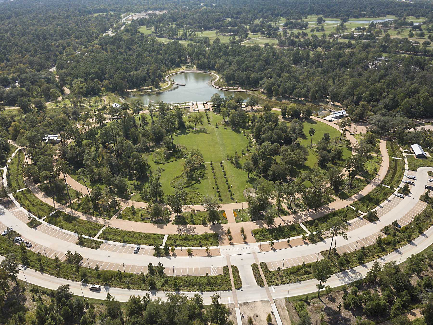
The first part of the Memorial Park master plan to be enacted was the Clay Family Eastern Glades project, which included the design and construction of a new artificial lake known as Hines Lake. The 5.5-acre lake and other aspects of the project provide stormwater treatment, flood control, habitats for aquatic wildlife, and numerous recreational facilities as well as other benefits to the site and the local community. The project was funded in part by a $10 million donation from the Clay family, which runs a development and construction firm.
Eastern Glades was completed in two phases — in 2018 and 2020, respectively, notes Charles Penland, P.E., M.ASCE, a managing principal in the Houston headquarters of Walter P Moore and the firm’s director of business development for infrastructure. Walter P Moore was a leading consultant on the Eastern Glades project, focused on the civil engineering and water resources aspects.
Memorable site
At roughly 1,500 acres, Memorial Park measures nearly twice as large as New York City’s Central Park. Once the home of a World War I training camp, the space officially became a city park in 1924, dedicated to the memory of the soldiers killed in that conflict. Expanding in size and amenities over the decades, the park grew to include a golf course during the 1930s and an arboretum in the 1960s.
Today, it features approximately 30 mi of hiking, biking, and walking trails, picnic areas, sports facilities, and other attractions. Roughly 4 million visitors use the park each year.
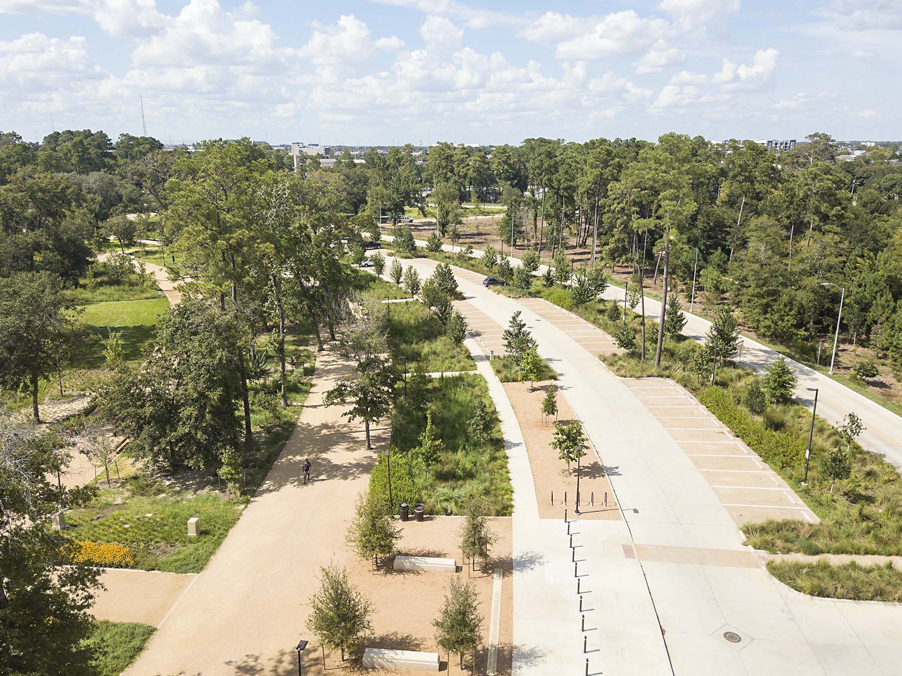
The park is approximately 4 mi west of downtown Houston, north of the Buffalo Bayou. Memorial Drive, a major highway for the city, cuts through the park from east to west, and a large section of the green space is bounded by segments of Memorial Loop Drive. Eastern Glades was constructed within that loop, portions of which were relocated as part of the current project to create a contiguous landscape and remove road crossings that posed hazards to wildlife. Materials from sections of demolished roadways were reused on other projects within the park.
The first phase of the Eastern Glades project essentially helped prepare the site for the more significant work of the second phase, says Penland. The first phase involved improvements to key infrastructure elements, including the park’s roads, parking lots, and the drainage systems that would eventually help feed Hines Lake, which was planned as the centerpiece of the second phase.
The area on which the Eastern Glades project was constructed encompasses roughly 100 acres of land that previously had been underutilized — wooded, with some swales to collect stormwater runoff from the rest of the park but otherwise a largely unused, practically inaccessible space, notes Christina Hughes, P.E., M.ASCE, a water resources engineer in Walter P Moore’s Houston office.
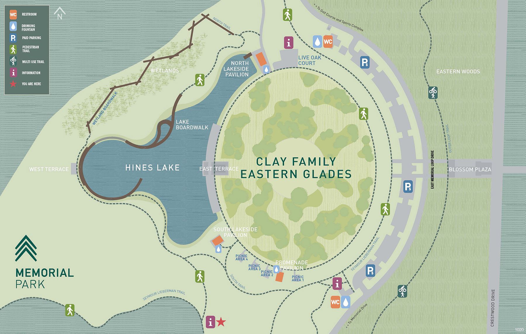
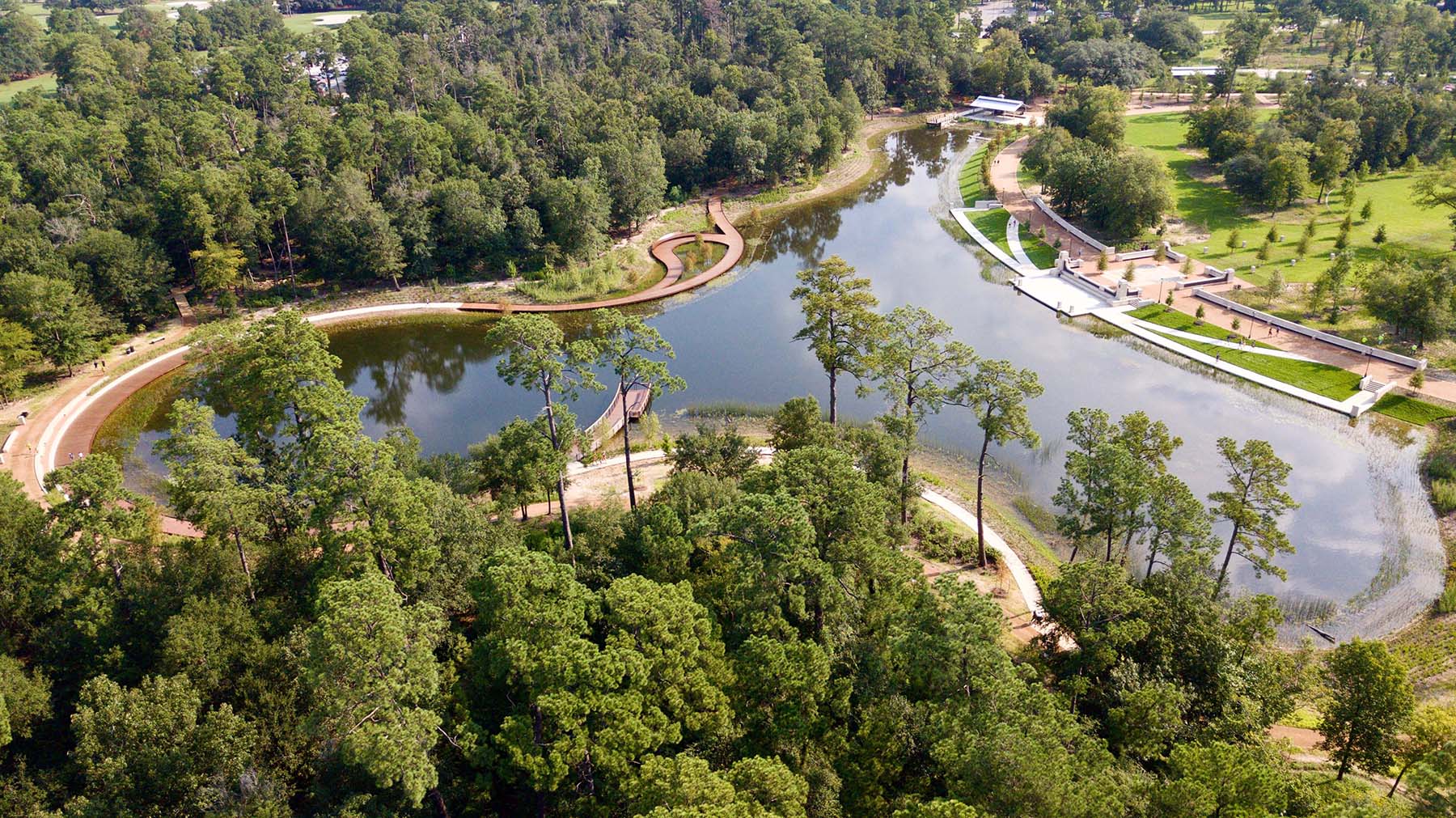
Constructed along an east-west axis, Eastern Glades features a 5.5-acre oval-shaped central lawn at its eastern edge flanked by Hines Lake to the west. Native plants line the lake, providing forage for dozens of local bird species. Rainwater and runoff from the nearby parking lots feed the lake, and the surrounding bioswales are designed to remove contaminants and sediment from the water. The system’s plants and soil work to divert and slow the rate of runoff that ultimately flows into the lake and then from the lake into a ravine at the golf course, which is then discharged into a tributary of Buffalo Bayou and then out to the bayou itself, explains Hughes.
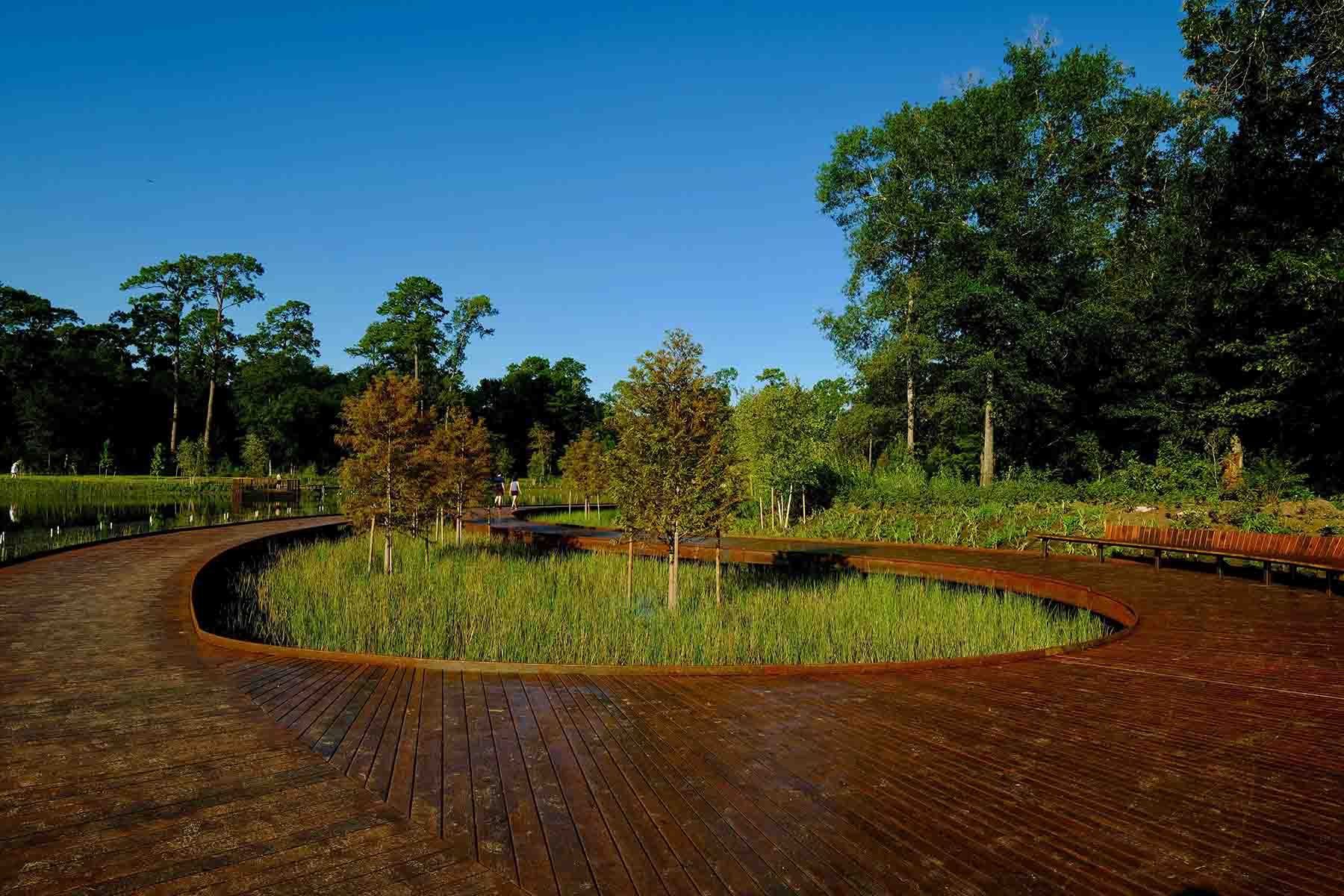
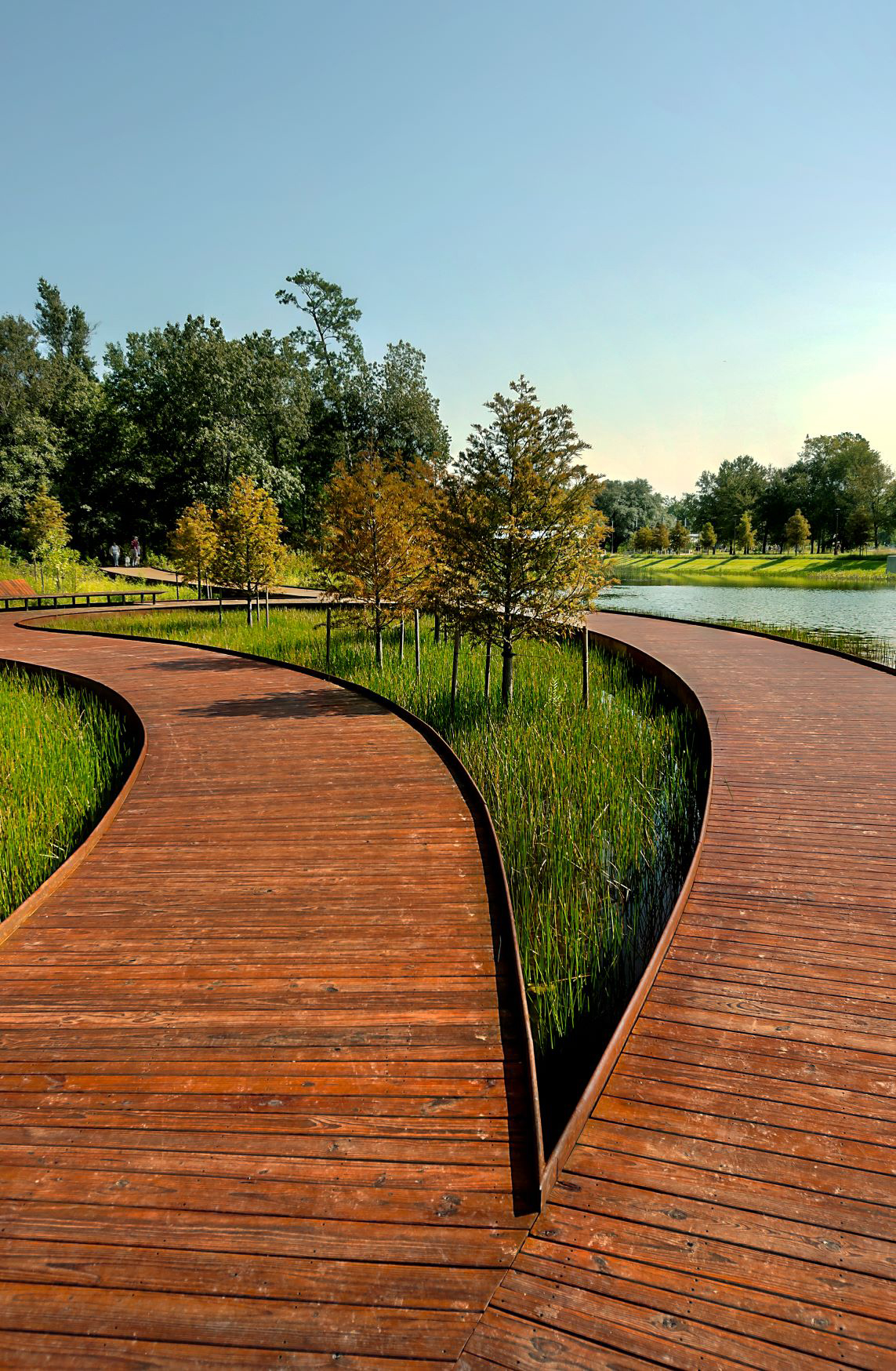
Eastern Glades includes 1.5 acres of wetlands — critical “to holding and directing the 50 inches of rain that falls per year on average in the city,” according to the conservancy. There are also 4.5 acres of native savanna, sections of prairie habitats, and an upland forest region. More than 2 mi of new trails and promenades provide access around the site, with sections of elevated timber boardwalks, piers, and bridges. These are founded on timber piles and concrete footings imbedded in the underlying soil and cross or extend over portions of the lake and wetlands.
Irregular design
Detention pond systems often feature geometric shapes with hard corners and straight edges that are obviously artificial, but Hines Lake features an irregularly shaped form that is intended to appear natural rather than constructed. The design includes various features to hide the infrastructure that makes the water resources systems function. Hines Lake “was intentionally given a nonuniform shape so (that) there was variation in the sides of the lake and the vegetation could vary along the edges,” making the site more conducive to the formation of animal habitats, Hughes says.
In plan, the lake resembles an octopus, its arms bunched together, extending to the north and south, while its bulbous head reaches westward, Hughes explains. At the ends of those north and south “arms” are the forebays, which serve as the inflow points for the stormwater that gets directed toward the lake. The stormwater is conveyed via concrete pipes that range in diameter from 36 in. in the north forebay to 48 in. in the south forebay.
Forethought guided the construction of these forebays, especially the southern one. During the first phase of the Eastern Glades project, a temporary detention pond was carved out of the site that later became the south forebay — “purposely placed there so it would then become part of the actual lake,” notes Elise Madray, P.E., an associate civil engineer and project manager in Walter P Moore’s Houston office.
Although the lake is used to treat stormwater runoff, the design also works to reduce the maintenance requirements for the conservancy. In a basin used to collect particulate-laden water, the sediment and other particulates will settle over time and accumulate at the bottom of the lake. This means that on a recurring basis, “you’d have to dredge the entire lake to maintain the level of storage volume available,” Hughes explains.
Instead, the north and south forebays, which are separated from the main body of the lake by underwater barriers formed by the grading of the lake bottom, take care of that problem. The lake bottom features a clay liner to reduce seepage. Because the water from the forebays must flow up and over the barriers to enter the rest of the lake, most of the sediment and particulates stay behind, accumulating at the bottom of these smaller spaces. “Then these smaller areas can get drained out without draining down the whole lake,” Hughes explains.
The barriers are submerged at least 3 ft below the lake surface to make them relatively invisible, and the inflow pipes — as well as a single 48 in. diameter outflow pipe — were constructed from a darkened concrete mixture. The color makes them “difficult to see from the surface of the lake,” Hughes notes, which helps achieve the conservancy’s goal of maintaining a natural appearance.
Likewise, the restrictor structure — used to control the outflow of water from the lake — was constructed as an underground junction box approximately 200 ft west of the lake, in a part of the park not publicly accessible. “The purpose was to try to minimize the amount of infrastructure that made this lake look like it was man-made,” Hughes says. The client did not want “a lot of concrete sticking up.” The restrictor system features a 12 in. thick concrete wall with a series of stepped weirs — including a 6 in. tall steel structure — that restrict the water discharge to help prevent downstream flooding and erosion.
On the edges
The edges of the lake feature two distinct designs, notes David Lundberg, P.E., a project manager and engineer in Walter P Moore’s Austin, Texas, office. Some portions of the lake perimeter are sloped and vegetated, the steepness of the slopes varying. “It’s not one consistent slope — it kind of undulates, which also helps with the natural effect,” he explains.
 it photo credit]
 But the slopes and vegetation also make it difficult for people to directly approach the water. So other locations around the lake edge, especially on the east and west sides, feature bulkheads — vertical reinforced-concrete retaining walls, like terraces — that enable visitors to get much closer to the water.
Although most of the lake features depths that vary from 8.5 to 9.5 ft, there is also a series of variously graded shelves or “benching” along the vegetated portions of the lake that are only about 3 ft deep. In addition to providing a more natural look to the site, the benching was designed to accommodate different types of plants, including various wetland and riparian species, Hughes notes. These shallower areas also provide a safety benefit — for example, if a child were to fall into the lake.
Variations in the grading of the benching, as well as along the lake bottom, were also intended by the project’s lake design consultant — Houston-based Berg-Oliver Associates Inc. — to optimize fish habitats, especially for some aquatic species that prefer sheltered areas.
The lake also features a circulation system comprising a series of intake pipes, outflow pipes, and pumps that “keep the water moving, which discourages algae from forming and helps keep the water oxygenated,” notes Lundberg.
At a pavilion near the north forebay, a small waterfall functions as another part of the circulation and aeration system. There are also small blocks of concrete set in, under, and above the water. These blocks are marked with the various potential elevation levels of the water, serving an educational purpose for visitors. They can “see what the water level is and see how that pertains to the function of the lake,” notes Penland.
First foot
Although Memorial Park is connected to Houston’s municipal water system, in case of future droughts, the Eastern Glades portion is designed to rely on Hines Lake for irrigation needs. The first foot of water over the entire lake, located generally between 52 and 53 ft above sea level, is reserved for on-site irrigation, Hughes explains, and flows out from the lake via a gravity system. If the water level falls too much because of a lack of rainfall or seepage, Eastern Glades can purchase water from the city “to resupply the lake to maintain the elevation,” Hughes says.
“But for the most part, we believe that, based on our analysis, there’s about 86% of the year when we can provide the water” directly from Hines Lake, Hughes explains.
An inlet to control the large amounts of runoff sedimentation that would occur during the construction phase was established atop the main outfall pipe. Then “we bricked up the interior of the pipe so it would retain water to a certain level,” says Lundberg. The plan had been to remove the bricks from the pipe at the end of construction so that it could function as part of the outflow system, at which point the inlet would become obsolete.
But the lake was accidently filled with water above the elevation of the outfall pipe before the bricks could be removed, Lundberg says. The project team was concerned that divers would have to “swim down there in scuba suits with sledgehammers to knock the bricks out!”
Fortunately, engineers determined that the inlet could accommodate the full flow of a major storm event. And the pipe itself features a 4 ft by 4 ft steel grate through which water can enter, bypassing the bricked-up section. “So water flows into the inlet, through the pipe (via the grate) to the restrictor structure instead of going directly into the pipe via the bricked-up entrance,” Lundberg explains.
“It was an unintended consequence, but it worked out for the better!” concludes Penland.
Early in the design process for Eastern Glades, Walter P Moore conducted a water balance study that considered all the sources of water that could be collected for reuse as well as all the potential demands for water on-site. “We looked at or estimated what typical rainfall we could expect on a monthly basis, both in a typical year and a drought year, to estimate how much water would actually make it to the lake,” Hughes says. “Then we looked at typical evaporation rates and seepage and what the demands would be for irrigation to see how much water we’d need.”
The water balance study helped the team understand “that we actually would be able to use the water beneficially,” Hughes says.
Saving the green canopy
Since the die-off of trees during the 2011 drought helped spur the development of the Eastern Glades project, it is only fitting that the project team worked hard to preserve as much of the remaining green canopy as possible. As Madray explains, “during the first phase, we walked the entire site” with the Memorial Park Conservancy staff and the local landscape architect — Lauren Griffith Associates — to conduct a tree survey, identifying how many trees could be saved and where they were located. For example, the trails in the wooded areas “were designed to meander around the trees that were still healthy,” she adds, and where trees had to be removed, new trees were planted in other locations.
Within the large grassy oval, in particular, the trees that needed to be saved were marked, and the grading was designed to ensure that sufficient water would continue to flow toward those areas that had always been naturally wet. The conservancy “very specifically wanted two areas of the large oval to remain as dry as possible after a rain event,” Madray adds, so considerable care had to go into the grading there and the design of a drainage system so that the trees could be preserved while the site itself drained quickly.
“It was definitely one of the more challenging aspects of the project in terms of grading everything so it actually drained into those sort of ‘islands’ where we were preserving the existing trees and the landscaping,” notes Lundberg. “But you also don’t want to create a swampy area in your nice grassy lawn.”
Nature-tested
Hines Lake was designed without a traditional emergency overflow system that a typical detention pond might have, says Hughes. Instead, during an extreme storm event, the water is expected to simply pond on the site. “We designed this entire park to flood in order to prevent passing that water down to an area that we’d want to keep dry, like Memorial Drive,” she notes.
“The natural direction for an extreme event overflow is to the roadway — but it was more important to keep the roadway dry. So we’re actually holding more water on-site, over-detaining during an extreme event, and allowing some of these picnic areas and trail areas to flood rather than pushing the floodwaters downstream,” Hughes explains.
The elevation of Hines Lake is significantly higher than the ravine it drains into, adds Lundberg. “So one of the things we had to do with the restrictor structure was make sure we could control the velocity of the water so that when it does outfall over by the golf course, it doesn’t erode away the ravine and cause damage to the course.”
The restrictor structure was designed to attenuate some of that velocity, and the design team conducted a backwater analysis on the ravine to ensure that the outfall would not add to any potential flooding. This work occurred during the summer of 2017 when Hurricane Harvey struck the region, “so there was a lot of attention on trying to see what we could do, as much as possible, to add to the flood protection element ... capturing water, holding water on-site, attenuating water, and keeping as much out of the bayou as we could,” says Lundberg.
Tropical Storm Imelda struck Texas in 2019 — testing the water resources systems while Eastern Glades was under construction — and then in September 2020, shortly after the project opened to the public, Tropical Storm Beta hit the Houston area. With Beta, there were heavy rains for roughly four consecutive days, notes Hughes, which put the new stormwater control features to an almost immediate test. Fortunately, “the lake performed fine, there were no drainage issues, no overflowing or erosion,” Hughes reports.
Looking forward, the Memorial Park Conservancy is taking steps to ensure the Eastern Glades project earns SITES certification, which is the sustainability-focused land development rating system aimed at protecting ecosystems and promoting climate regulation, carbon storage, and flood mitigation. The SITES system was developed by the American Society of Landscape Architects, the Lady Bird Johnson Wildflower Center at the University of Texas at Austin, and the United States Botanic Garden.
The SITES program is administered by Green Business Certification Inc. The U.S. Green Building Council, which manages the Leadership in Energy and Environmental Design green building rating system, is a long-time supporter and stakeholder in the SITES program.
Additional parts of the Memorial Park master plan are expected to be completed during 2022, including a so-called land bridge that will span Memorial Drive to reunite the north and south portions of the park. A restored prairie area adjoining the land bridge is also planned.
Working together with the wetland areas, the prairie space will provide “important habitat and stormwater management functions,” the conservancy explains, and serve as “a key part of the park’s ecological restoration to ensure resiliency.”
Robert L. Reid is the senior editor and features manager of Civil Engineering.
PROJECT CREDITS
Client: The Memorial Park Conservancy, Houston
Landscape architect: Nelson Byrd Woltz Landscape Architects, offices in Houston, New York City, and Charlottesville, Virginia
Lead engineering consultant: Walter P Moore, Houston
Local landscape architect: Lauren Griffith Associates, Houston
Lake design consultant: Berg-Oliver Associates Inc., Houston
General contractor: Tellepsen Builders, Houston
Boardwalk and bridge consultant: York Bridge Concepts, Lutz, Florida
This article first appeared in the July/August 2021 issue of Civil Engineering as “One Park, Many Functions.”