By Robert L. Reid
A new dam and reservoir to impound reclaimed water in Southern California was created on the site of an abandoned industrial reservoir. Construction at the extensive work site benefited from a drone-based mapping software system.
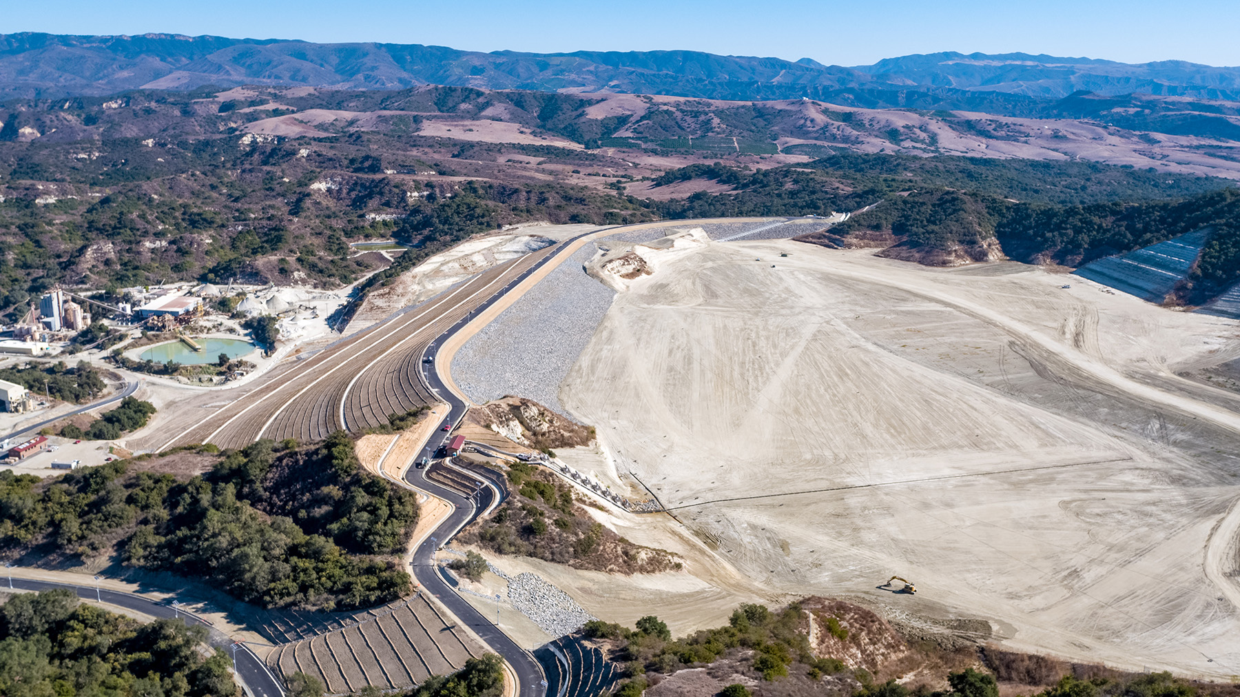
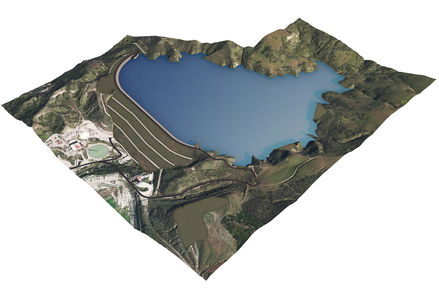
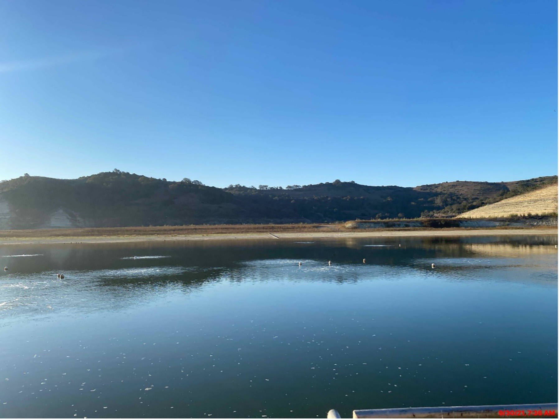
An abandoned reservoir once used as part of a sand mining operation in Southern California’s Orange County has, appropriately enough, been recycled into a new reservoir to impound recycled water that the region will use for irrigation and other nonpotable purposes. Known as the Trampas Canyon Dam and Reservoir, the new 1.6 billion gal. reservoir is the largest facility of its kind in Orange County and the first to be constructed there in decades.
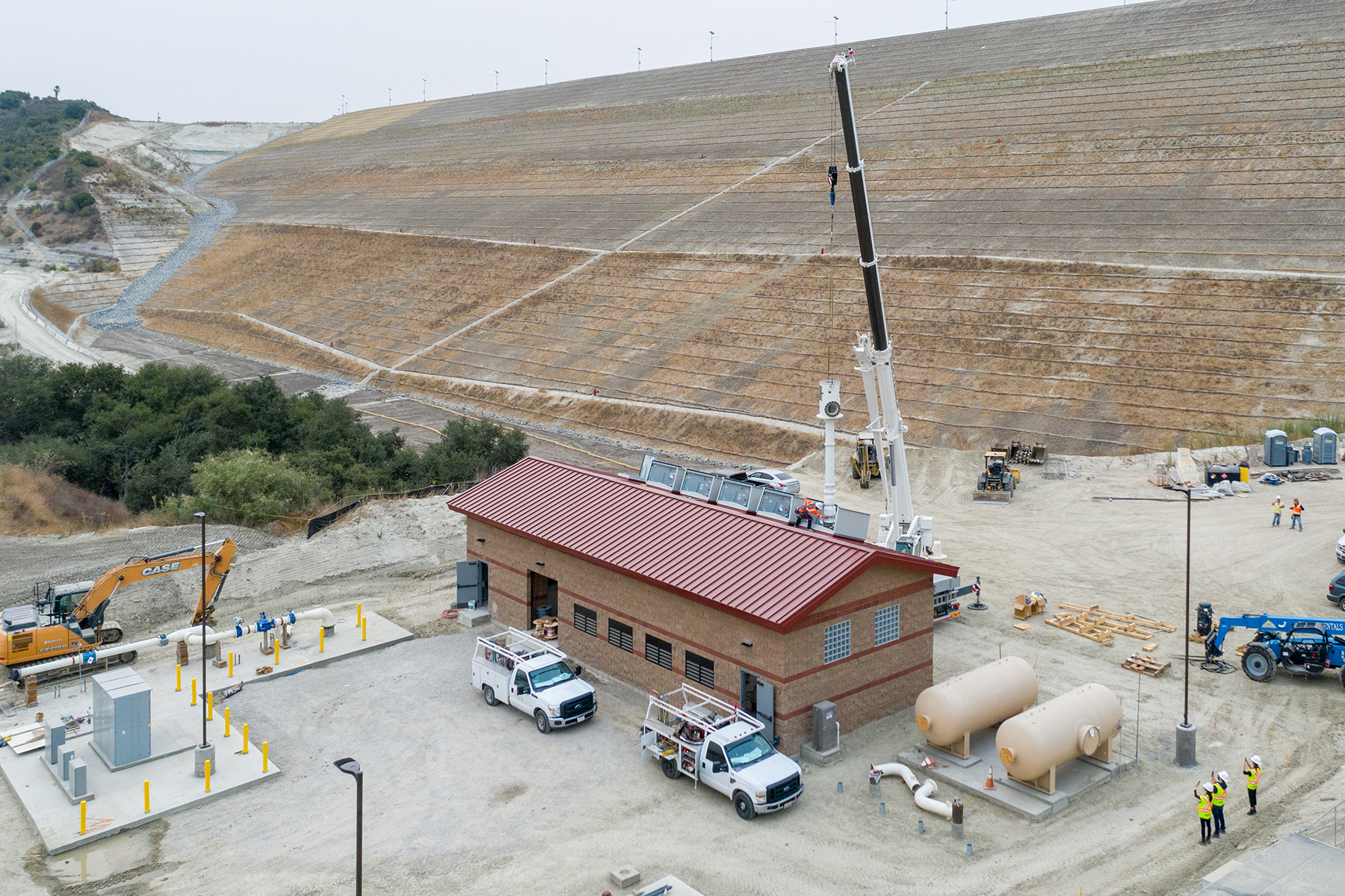
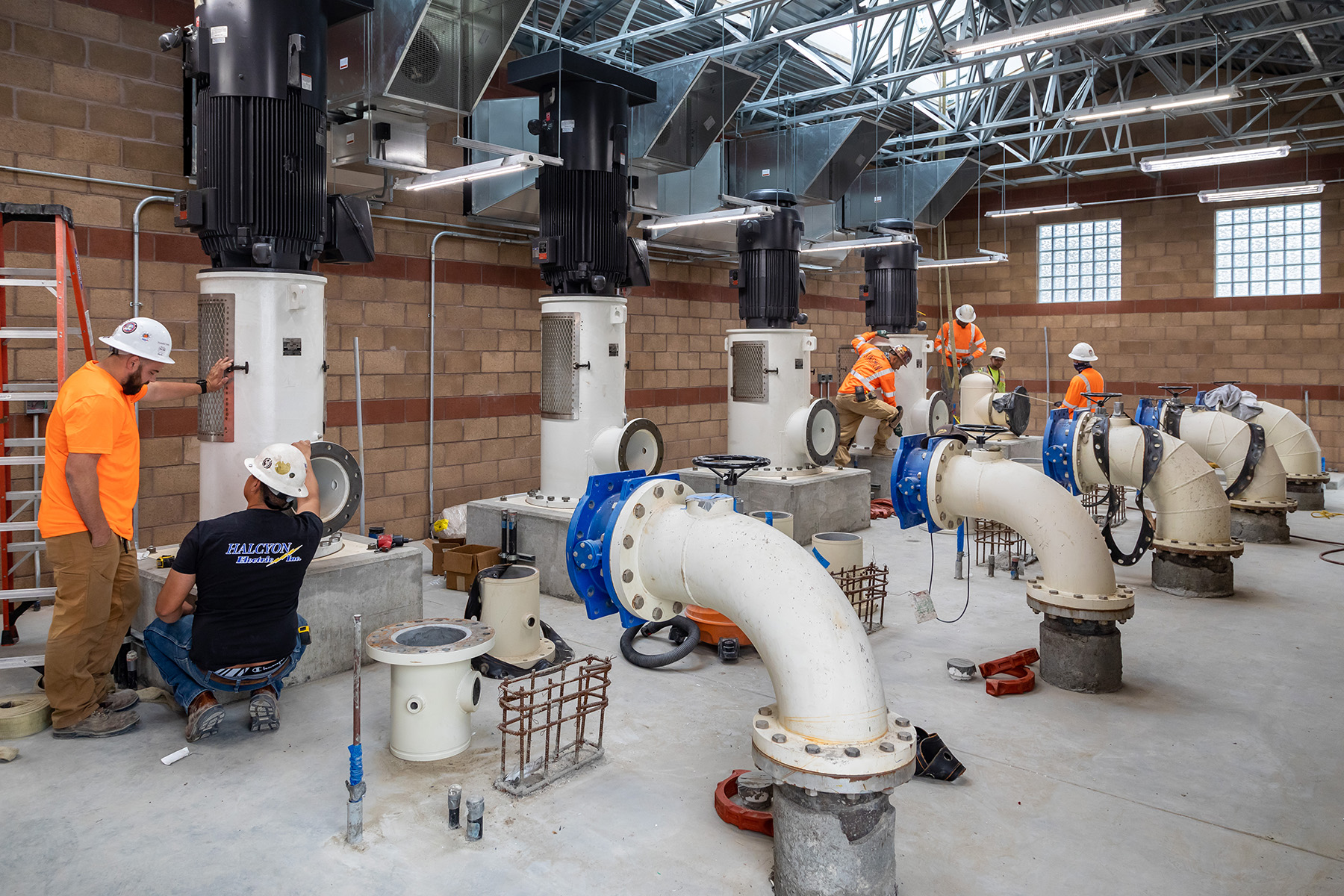
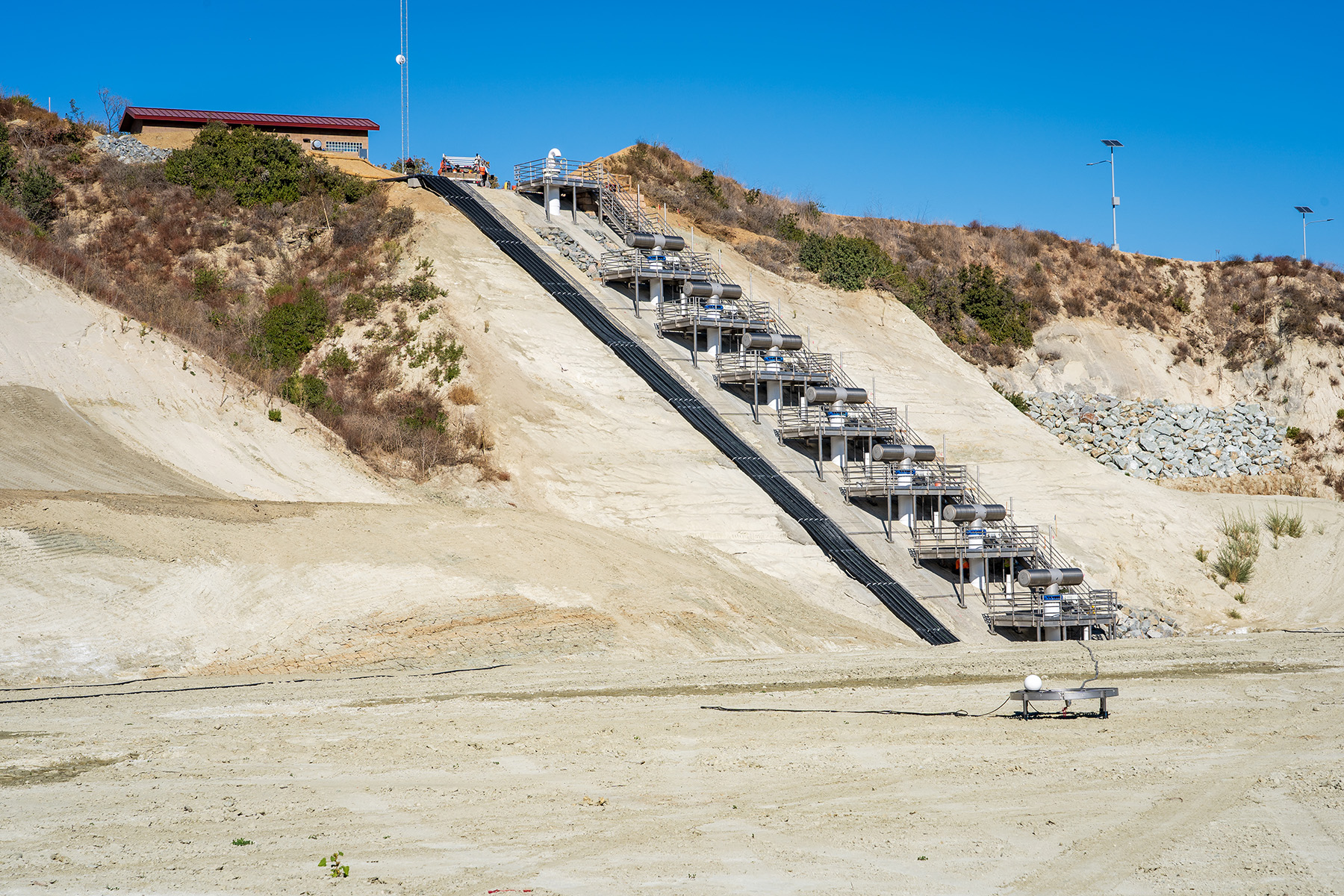
It features a 216 ft tall earthen main dam plus two smaller earthen dams to the east and west of the main dam. There is also a 400 ft long concrete spillway with 15 ft tall walls; more than 9,000 ft of cement mortar lined and coated steel pipe; a concrete-encased inclined inlet-outlet structure; a 315 ft long boat launch ramp for workers performing maintenance or conducting water quality checks; a pump station with five pumps, each of which is capable of moving 3,000 gal. of water per minute; and a dam control building, according to information from members of the design and construction team as well as the owner, the Santa Margarita Water District.
About 6,800 ft of new asphalt roads were also constructed and some 20,000 linear ft of perimeter fencing was installed to secure the site, which is not open to the public.
Construction of the $123 million project was completed in April 2021. That same year, the project was honored by ASCE’s Orange County Branch of the Los Angeles Section as its 2021 Outstanding Geotechnical Project.
At press time, the site was in the process of being filled with recycled water from various local sources — a process that will take several years to complete because the filling must be conducted slowly and carefully monitored to be certain the dam can accommodate the ever-increasing loads of water, notes Michael G. Smith, P.E., G.E., M.ASCE, a principal engineer in the Orange, California, office of the international engineering firm AECOM. The firm was the lead design engineer on the recycled water reservoir project for the SMWD, which is responsible for filling, monitoring, and eventually operating the new dam and reservoir.
Sukut Construction LLC was the general contractor, GMU Geotechnical Inc., was the project’s geotechnical engineer, and Butier Engineering Inc. provided construction management and inspection services.
The reservoir itself will measure some 3,000 ft across and 80 ft deep at its lowest point. Recycled water for the reservoir will be provided primarily by the SMWD’s Chiquita Water Reclamation Plant as well as other reclamation plants and recycled water sources in south Orange County.
Earthen efforts
The original sand mining reservoir featured an earthen dam roughly 175 ft tall that was constructed in the 1970s to retain tailings — a silty, watery byproduct of the mining work, says Smith. By 2014, however, the sand mining operations had ended and the tailings reservoir had been shut down. But by then the site had attracted attention from the SMWD for repurposing and reconstruction. Working with the local community of Rancho Mission Viejo, the SMWD acquired the site in 2017 to provide greater recycled water seasonal storage and increase water resiliency.
Previously, the SMWD had treated reclaimed water for nonpotable uses during the spring and summer, when demand was high to irrigate golf courses, common green spaces, and similar settings, notes Greg LeBlanc, P.E., a Sukut project manager. But in the fall and winter, when demand decreased, much of the reclaimed water the district collected was simply sent out to the ocean. That was a waste of water in drought-prone Southern California, especially since the district was treating the water anyway, Le-Blanc says. So the SMWD decided to construct a new reservoir to preserve that resource.
Ironically, for a site that will eventually hold vast quantities of water, one of the first challenges of the project involved dewatering the reservoir. That’s because in late 2017 and early 2018 heavy rains in Southern California flooded the work site and required the removal of some 41 million gal. of water before construction could proceed in January 2018, explains an SMWD video about the project. After the rainwater was removed, Sukut excavated poor soils from the base of the original dam to allow the new dam to be constructed directly on bedrock.
A portion of the original dam’s crest was also removed so that the new, taller dam could tie into the original dam’s existing core, which featured an impermeable clay material to prevent water seepage through the structure, says Smith. “We had to chop off the top of the existing dam by a few feet to expose the core zone, that clay material, and then as we raised the dam, we added our own clay material and kept raising it to the top of the dam,” Smith explains.
The new dam is roughly 40 ft taller than the original dam. Because of the outward sloping walls of the surrounding canyon, the new dam is also more than 150 ft longer, measuring about 1,000 ft from end to end, in an east-west direction, says Smith. To construct the new dam, Sukut built up the existing embankment in a slow process that moved about 20,000 cu yd of soil at a time, which added only 1 ft of new material per day to the overall height of the structure, says LeBlanc.
Ultimately, the project moved more than 4 million cu yd of soil, most of it originating on-site, in a process made more efficient, accurate, and timely by a special drone and software project management tool that Sukut used (see the sidebar).
Additional dams and features
In addition to the main dam, the project also comprised two so-called saddle dams — smaller structures designed to enclose additional portions of the canyon for the reservoir — to the east and west of the main dam. Because of variations in the canyon topography, the east saddle dam measures 108 ft tall while the west saddle dam is just 46 ft tall, though the crests of all three dams align, Smith says.
Although there had been no other structure at the site of the west saddle dam prior to the current project, there had been a small dike, maybe 10 ft tall or so, at the location of the east saddle dam, Smith adds. That structure was demolished to access the bedrock on which the new saddle dam was constructed, he adds. Both saddle dams also feature clay cores to prevent water seepage.
A small existing spillway from the original dam was also demolished and the new, larger spillway was constructed on bedrock near the east saddle dam. Although the SMWD believes it unlikely that the dam will ever be overtopped, the spillway is designed as an emergency backup system with a maximum discharge capacity equal to the largest storm anticipated to hit the area: 301 cfs, explains the district’s video.
Other features of the project include the boat launch, a concrete-paved ramp and stairs that provide access to what will be a floating dock when the reservoir is full, and the boat launch, which was constructed on the reservoir side of the east saddle dam. There is also the inlet-outlet structure located in a rock outcropping between the main and west saddle dams.
The inlet-outlet structure is a concrete-encased pipe embedded at an incline in the bedrock along the bottom of the reservoir. Roughly 4 ft in diameter, the pipe features a series of ports or valves that enable water to enter and exit; the sloping design allows the district to put water into the reservoir or remove water at various elevations, even as water levels in the system rise and fall, Smith notes. Being embedded in bedrock also makes the structure more resilient to earthquake motions than a free-standing tower.
Located near the toe of the main dam is the masonry block pump station from which a series of high-capacity pumps will send the recycled water to users in the surrounding region, which includes Rancho Mission Viejo, the Talega Valley, the villages of Sendero and Esencia, the city of San Juan Capistrano, and others. The station’s five pumps will not operate simultaneously. Two of the pumps are reserved as backup units to help maintain overall system reliability, so if one pump needs maintenance, a backup pump can be turned on to ensure that there are no water service disruptions, the district explains.
A concrete-framed control building is where the reservoir crew will operate and maintain the daily functions of the reservoir and dams, moving water in and out of the site. District water quality experts will also keep an eye on the reservoir’s aeration system, which is designed to prevent the development of unwanted algae blooms in the water.
Groin drains, involving roughly 20 ft wide sections of riprap, were installed at the toe of the dam, extending up to the crown, to ensure the integrity of the dam embankment at the point where the new dam joins the valley walls, notes LeBlanc. The project also used pneumatic trucks to spray a mix of water, seed, and fiber onto any slopes that had been disturbed during the construction phase to revegetate those areas and help maintain slope stability, he adds.
Seismic solutions
The site of the Trampas Dam and Reservoir is geographically close to the Mission Viejo Fault, which had long been considered inactive and thus not a concern for the new structures, notes Smith. But when new information suggested the fault might still be active, AECOM conducted an investigation that included a geological literature review, geologic mapping and profiling, and pedogenic age-dating of a series of key terraces located across the canyon on the non-reservoir side of the dam, Smith says.
Because the fault passed through those terraces and presumably continued on toward the reservoir site, “our engineering geologists were able to use the terraces as a good global snapshot of the fault,” Smith explains.
AECOM’s team examined the geologic deposits in the terraces, looking for any displacement or offsets that might indicate the fault was indeed active. Fortunately, the geologists “confirmed that the fault was inactive and thus not a concern for our structures,” Smith says.
Other seismic-related work included efforts to found the new dams directly on bedrock and ensure that the filter and drain zones within the dam were designed large enough and with other properties to make them resistant even to strong shaking, Smith says. The engineers also conducted extensive analyses through numerical modeling to ensure that the strength and potential deformations of the dam would remain within tolerable limits during various potential seismic events and that the ability to release water from the reservoir or take other safety measures would still be possible following a major earthquake, Smith explains.
SIDEBAR
A watchful eye in the sky
By Robert L. Reid
During the construction of the new Trampas Dam and Reservoir, Sukut Construction LLC, the Santa Ana, California-based general contractor, often moved 20,000 cu yd of soil a day, slowly building up the embankments that would form the new 216 ft tall main dam and its nearby saddle dams. Keeping track of the work’s progress, the changing terrain and elevations, and other ongoing developments was critical and challenging for Sukut; the project’s lead engineering firm, AECOM; and the owner, the Santa Margarita Water District, notes Greg LeBlanc, P.E., a Sukut project manager.

Covering 177 acres, the work site was large, rugged, and potentially dangerous, with poison oak and rattlesnakes present and heavy equipment moving around the area. That made it difficult and time-consuming to send out a project engineer or grade checker to walk around the expanse of the site, taking notes and pictures to document the changing conditions, LeBlanc says. Moreover, Sukut teams might have had to wait until after normal work hours or even come in on weekends to collect the needed data, LeBlanc adds.
An alternate method of collecting this information involved employing aerial surveys using fixed-wing aircraft that would ultimately produce detailed topographical maps, says Marlon Delgadillo, a Sukut project engineer. But such flights can be expensive — costing as much as $20,000 apiece — and might take up to a month to finalize the maps.
Because of the size and complexity of the Trampas project, Sukut rejected those traditional approaches and turned instead to a relatively new project management method for the firm: unmanned drones using data analytics and visualization software.
Specifically, Sukut used a post-processed kinematic system to capture geotagged aerial images for drone mapping together with the AeroPoint smart ground control station to upload data wirelessly — both the PPK and AeroPoint systems were manufactured by Propeller Aerobotics Pty Ltd., based in New South Wales, Australia. The PPK software was flown by Sukut’s own certified drone pilots on drones made by DJI, based in Shenzhen, China.
The geographic information system data were then used to create 3D site surveys within 24 hours, “with all the measurement and analysis tools needed to report out on quantities, volumes, and more,” according to a Trampas Dam case study on the Propeller website.
The nearly real-time nature of the Propeller data allow “you to plan the work more efficiently,” Delgadillo explains. “If I have an aerial (topographical map) and know how much quantity we moved and where things are currently, we can change the logistics going forward” or make other changes, Delgadillo says.
Although the drone flights were conducted only about once a month, the data retrieved and the resulting images were used on a regular basis throughout the month and shared with AECOM’s engineers or the client’s staff. “Having this data, we were able to get a really nice snapshot of the topography,” says Michael G. Smith, P.E., G.E., M.ASCE, a principal engineer in AECOM’s Orange, California, office. “So we knew, for example, on a certain date what the ground surface looked like — and that was very helpful in our analysis and evaluations.”
Because the system’s visualization platform is cloud-based, the 3D site surveys can be viewed from essentially any location with an internet connection. Delgadillo says he used that function on several occasions from Sukut’s office in Santa Clarita, California — a roughly two-hour drive from the Trampas work site. “I just had to fire up a browser, log in, and I could pull the data that I needed,” Delgadillo says.
Sukut had used the PPK software on at least one earlier project. For the Trampas project, the firm initially planned to use the system just to determine soil quantities, but the firm’s team soon realized it could also help with photographs, information for the owners, as-built information, alignments, determining where to send employees across the expansive work site, and other functions, LeBlanc says.
“It’s a new technology,” LeBlanc explains, “so as you become more familiar with it, you find more uses for it.”
Project credits
Client: Santa Margarita Water District
Lead engineer: AECOM, Orange, California office
General contractor: Sukut Construction LLC, Santa Ana, California
Geotechnical engineer: GMU Geotechnical Inc., Rancho Santa Margarita, California
Construction manager: Butier Engineering Inc., Tustin, California
Aerial mapping software provider: Propeller Aerobotics Pty Ltd., New South Wales, Australia
Robert L. Reid is the senior editor and features manager of Civil Engineering.
This article first appeared in the September/October issue of Civil Engineering as “Recycled Reservoir.”