By Robert L. Reid
To improve the safety and performance of a pair of dams in central California, the U.S. Army Corps of Engineers raised the heights of both structures and added an arced labyrinth weir. An enormous physical model helped test the Corps’ design.
Although the shortest distance between two points is, famously, a straight line, that shortest distance is not necessarily the best solution to certain engineering challenges. That is what the U.S. Army Corps of Engineers determined during the Isabella Lake Dam Safety Modification Project that entailed the design of a weir for a new emergency spillway as part of a dam safety improvement effort.
The nearly $650 million project, roughly 40 mi northeast of Bakersfield, California, began construction in 2017, was substantially completed in late 2022, and was scheduled for full completion by the end of May. The overall project is designed to reduce the risk of flooding in the southern Central Valley region of the Golden State by addressing overtopping, seismic, and seepage concerns at the two earthen dams that impound Lake Isabella, an artificial reservoir that serves as the primary water source throughout the Kern County region.
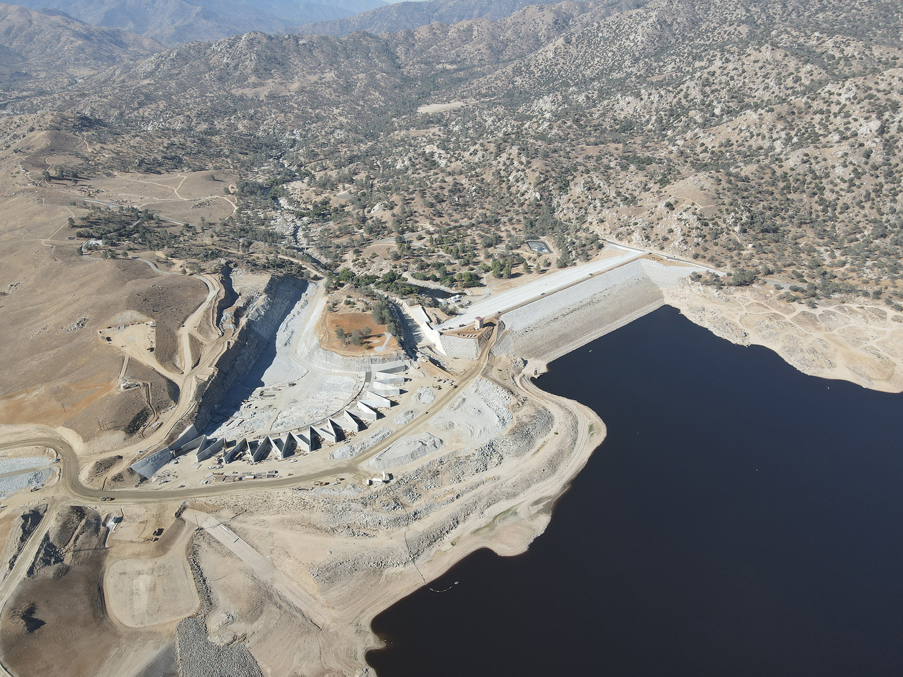
The site features a 185 ft high main dam and a 100 ft high auxiliary dam that were completed in 1953 to create a reservoir with a gross storage capacity of 568,000 acre ft under normal, non-flood conditions. Both dams are oriented in the east-west direction, with the main dam on the western end of the site, the auxiliary dam roughly 2,500 ft away on the eastern end, and a service spillway in between the structures.
In 2005, however, as part of an ongoing dam safety assessment program, the Corps identified several critical problems with the Lake Isabella dams, says Victor Ozuna, P.E., a resident engineer in the Corps’ Sacramento (California) District office. Both dams were in danger of being overtopped during a flood and were experiencing seepage problems. In addition, the auxiliary dam was at risk of internal erosion due to the presence of an abandoned conduit, known as the Borel Canal, that ran through the center of the auxiliary dam and was once used to provide water to a local hydropower-generating plant owned by Southern California Edison.
Although the main dam was constructed atop essentially “perfect” geologic conditions of solid granite, Ozuna notes, the auxiliary dam had been built on alluvial sand over a fault line that, while originally considered inactive, was later determined to still be active. As a result, the auxiliary dam also faced the possibility of failure because of displacement from a fault rupture and potential liquefaction of the underlying soil.
The Corps conducted a failure mode analysis involving a combination of visual inspections, computer simulations, field testing, and other measures. This analysis ultimately identified 21 ways the dams could fail, earning the Lake Isabella dams a rating of 1, which is the riskiest ranking under the Corps’ 1-5 Dam Safety Action Classification system, Ozuna says.
Critical improvements
To correct the many possible problems with the Lake Isabella dams, the Corps designed a series of critical improvements. These included buttressing and raising both dams by 16 ft, improving the foundations of the auxiliary dam, capping and filling in the abandoned conduit that ran through the auxiliary dam, and constructing a new emergency spillway with a zigzagging labyrinth weir.
The existing service spillway had a discharge capacity of 50,000 cfs, but when combined with the new labyrinth weir, the dams have been designed to discharge as much as 506,000 cfs during the probable maximum flood.
The project rerouted a portion of State Route 155 that had crossed the crest of the main dam. The Corps also constructed 16 ft high walls on either side of the road, along a length of about 450 ft, so that in an overtopping event the road can act as yet another spillway.
The Corps had been concerned that an overtopping of SR 155 could damage the groin of the main dam, Ozuna explains. Although Corps engineers initially considered adding a gate to close off the highway during a flooding event, their final plan redesigned the road to “flush out the water, away from the groin of the dam, protecting the main dam from erosion,” Ozuna explains.
On the other side of the project, the Corps had also considered relocating a portion of SR 178 for similar reasons. But instead “our engineers were able to change the shape of the dam,” adding in a curve “that allowed us to avoid relocating that (portion of the) highway, which saved both time and money for the overall project,” Ozuna explains.
Much of the land around the Lake Isabella dams was under the jurisdiction of the U.S. Forest Service, including a fire station and a visitor center on a bluff overlooking the lake, right where the labyrinth weir was planned. So, working with the Forest Service, the Corps demolished the two structures and built a new fire station and administration building as well as an interim visitor center for the Forest Service on the southeast side of the lake. A permanent visitor center will be constructed later in the town of Lake Isabella.
In addition to the Forest Service, the Corps credits a number of key partners who helped it plan and implement the Lake Isabella project. These include the prime contractor, a joint venture of Flatiron Construction Corp., Dragados USA, and Sukut Construction LLC; Utah State University; the global engineering firm HDR; the Corps’ own Dam Safety Production Center; and various federal and local government agencies, local communities, and other stakeholders.
Hydrologic centerpiece
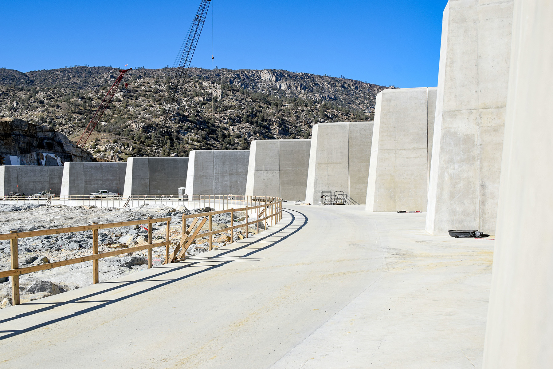
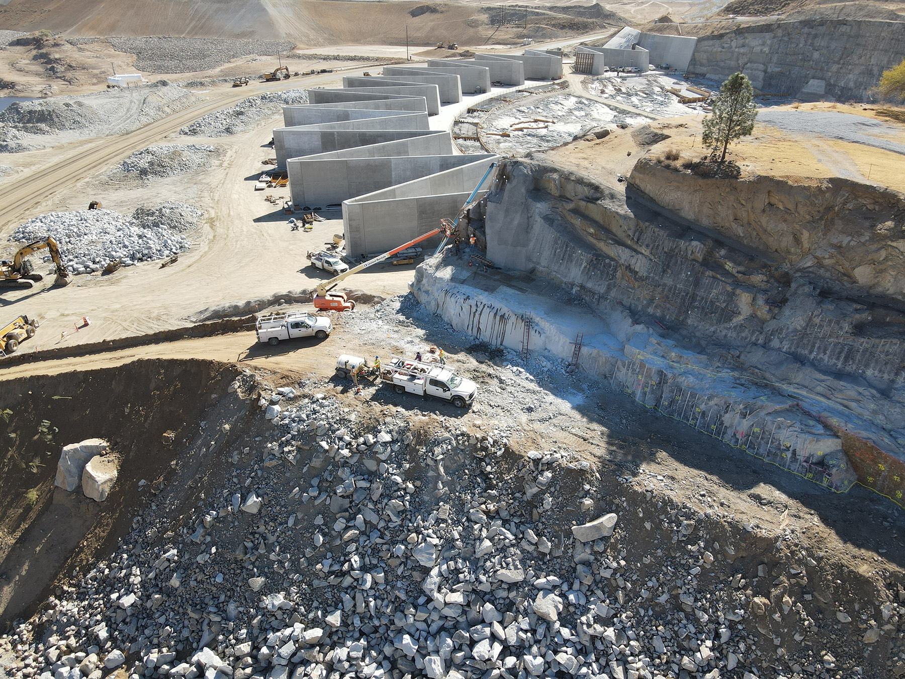
A centerpiece of the dam safety modification effort, literally and figuratively, is the labyrinth weir, which is a walled structure across the emergency spillway channel designed to control the discharge of water. Although the Corps initially considered a traditional weir featuring a straight wall, “the hydrology calculations didn’t add up,” Ozuna says. That’s because the Corps needed roughly 3,100 ft of weir within a space for the emergency spillway that was only 1,200 ft wide.
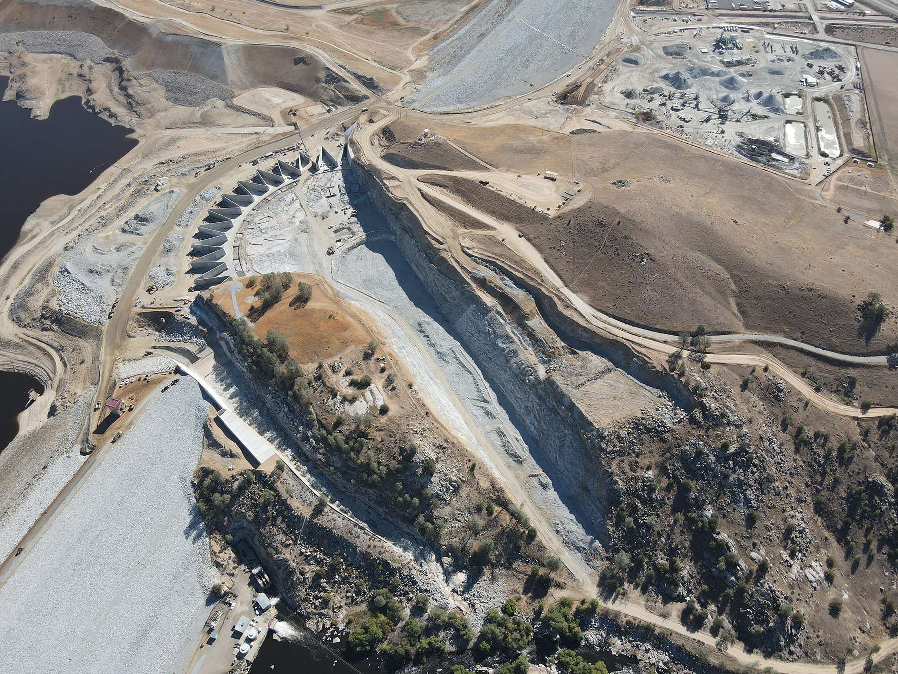
So instead of following the traditional route, the Corps designed a labyrinth weir with folded, or zigzagging, walls in 12 repeating cycles in an arced formation, a design that provides a greater weir length within the given channel width. Secured to a concrete slab foundation, the labyrinth walls measure 28 ft high and 5 ft thick at the base, tapering to 2 ft thick at the crest, Ozuna says. On the downstream side, the weir arc measures slightly more than 930 ft long while the larger, upstream portion measures 1,200 ft long, giving the entire structure a total wall length of approximately 3,100 ft.
The Corps designed the labyrinth weir based in part on published research from the Utah Water Research Laboratory, which is operated by the Civil and Environmental Engineering Department of Utah State. Prior to starting construction, the Corps asked the lab to help verify the efficiency and utility of the weir design. This was accomplished in 2014 on an enormous physical model, roughly one-third the size of a football field, that was erected in a large hydraulic facility within one of the laboratory’s main buildings (read “Large-scale physical model confirms California weir design”).
A series of tests sent water rushing through the 1:45 scale model of the weir, proving that the zigzagging design would work for the Lake Isabella dams. Other results from the model also persuaded the Corps to simply purchase the nonoperational Borel Canal conduit from Southern California Edison and fill it in, rather than construct a tunnel to reroute the conduit for the utility. This again saved the project time and money, Ozuna says.
On-site materials
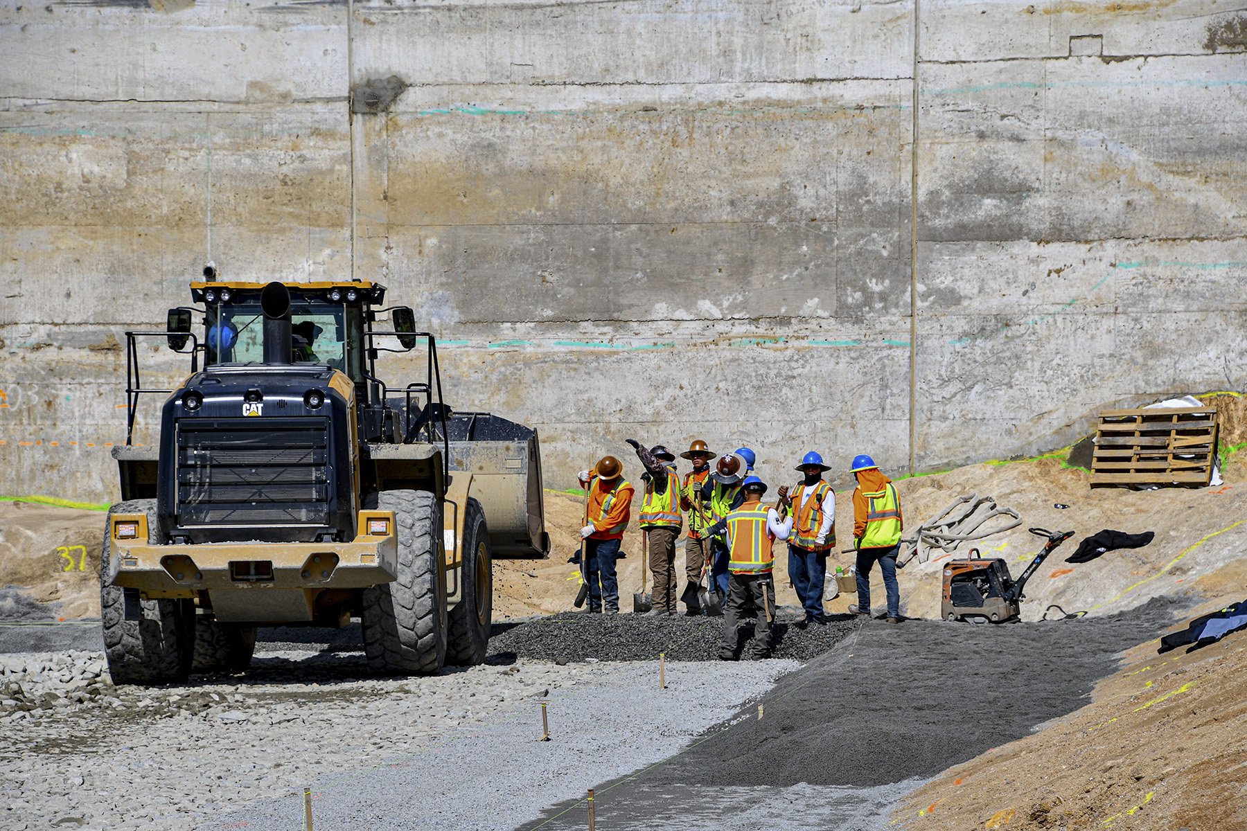
To reinforce the foundations of the two dams, the project team excavated beneath the structures and then installed so-called zone blankets of various soil materials to a depth of roughly 10 ft at the main dam and fully 30 ft deep at the auxiliary dam because of its poor underlying soils and the active fault. The downstream embankments of both dams were then buttressed with a thick overlay of strips of different soil materials that raised the height of each dam by 16 ft. The overlay measured about 150 ft thick for the auxiliary dam and roughly 45 ft thick for the main dam, Ozuna adds.
In a rather out-of-the-ordinary move, made in part because of the remoteness of the work site, all the soil material used for the foundation improvements and the embankment buttressing was mined on-site. In a roughly three-year-long process, the project team excavated 3 million cu yd of material from the site of the new emergency spillway to carve out space for the spillway itself and to provide the material for the embankment work as well as aggregate for the concrete that was manufactured on-site, Ozuna explains.
“We were blasting rock two to three times a week,” he notes. “And then we had geologists on-site classifying the rock. Any type of rock that was suitable material was transported to our rock-crushing plant, and from there we produced the different embankment and aggregate materials.”
HDR assisted the Corps with mining engineering expertise.
Seismic events
Because the auxiliary dam could potentially move as much as 6 ft during a major seismic event, the project team also installed a system that will automatically fill any gap in the fault line with sand to prevent the dam from collapsing, Ozuna says. “The dam will be damaged,” he explains, “but it will not fail.”
Over the Fourth of July weekend in 2019, while the foundations of the auxiliary dam were exposed but before the sand system was in place, a large earthquake struck another nearby fault line. The dam’s operations and engineering departments, as well as the improvement project’s construction team, each investigated the auxiliary dam in the aftermath of the earthquake and determined that the structure had not been damaged, Ozuna says. Normally, a single inspection by the operations team would suffice, but with the auxiliary dam’s foundations opened up that way, the project team wanted to be absolutely certain the structure remained safe.
Staying safe
In addition to that earthquake, the project also had to contend with a series of wildfires in the region, which required periodic evacuation of personnel as well as daily tracking of the air quality index during fire season. “There were days when it was so smoky, we couldn’t work,” Ozuna notes.
Other potential work site hazards were posed by the blasting operations, the movement of enormous construction vehicles around the work site, and certain complicated procedures, Ozuna says. In one case, an old concrete control tower connected to the Borel Canal conduit was being demolished and the lower portion filled in with a light cellular concrete.
Because light cellular concrete is a complex construction material, the work crew was getting frustrated and experiencing a number of near misses in terms of accidents within the tower, Ozuna says. Before an accident did occur, the project team stopped work on the tower, assessed the situation, and ultimately switched to a different material: a geofoam that was easier to work with.
“After we made that change, there were no further near misses,” Ozuna says. Ultimately, the project team completed 2.6 million work hours without a serious safety incident, a major accomplishment on this sort of project, according to Ozuna.
A better future
Although Ozuna initially wondered if the work site’s remote location might make it difficult to attract enough staff from within the Corps, “it was such a cool project that we eventually had to turn people away!” he says. Moreover, once people started work on the project they tended to stay: The workforce attrition rate on similar projects averages around 30%, Ozuna says, but the Lake Isabella attrition rate has been only about 5%.
The project also helped the Corps establish new relationships with California State University, Fresno, about 150 mi northwest of Lake Isabella. “We attended several Fresno State career fairs where we recruited several of their new engineering graduates to help us manage the project,” Ozuna says. “And several of our senior engineers gave class presentations on topics related to dam construction and construction management.” Corps personnel now sit on the university’s industry board as well.
As the Lake Isabella project neared completion at press time, the Corps could look back with satisfaction on the many challenges it overcame, the innovative solutions it employed, and the safer future that it, along with its many partners, created for those who use or live near the reservoir and dams.
The appearance of U.S. Department of Defense visual information does not imply or constitute DoD endorsement.
Robert Reid is the senior editor and features manager of Civil Engineering.
Project credits
Owner, operator, designer, and construction manager: U.S. Army Corps of Engineers, Sacramento (California) District
General contractor: Joint venture of Flatiron Construction Corp., Broomfield, Colorado; Dragados USA, New York City; and Sukut Construction LLC, Santa Ana, California
Physical model consultant: Utah Water Research Laboratory, Civil and Environmental Engineering Department, Utah State University
Mining consultant: HDR, Omaha, Nebraska
This article first appeared in the July/August 2023 print issue of Civil Engineering as “Zigzag Solution.”