By Ben Arndt, P.E., M.ASCE, Richard Johnson, P.E., James Dahill, P.G., Jeff Booher, P.E., and Seth Wittke, P.G.
When a section of an earthen embankment under a vital commuter route spectacularly collapsed, engineers and geologists quickly mobilized to rebuild the site.
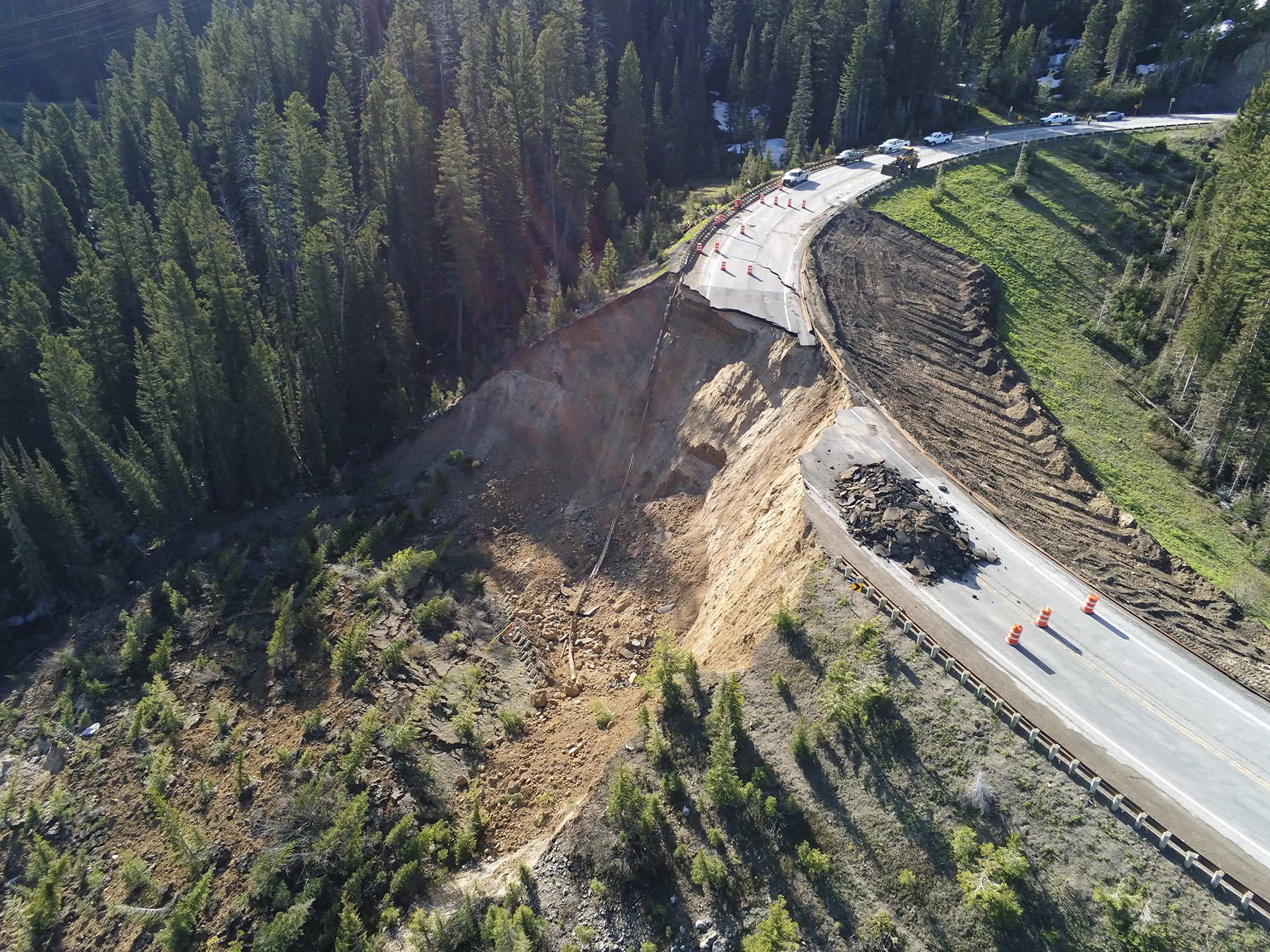
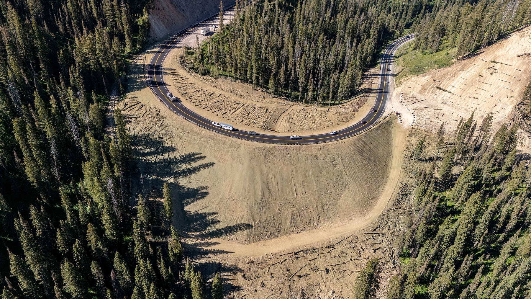
On June 8, 2024, a 70 ft high earthen embankment on Teton Pass between Jackson, Wyoming, and Victor, Idaho, failed catastrophically. The Wyoming Department of Transportation had been notified of the impending failure and was monitoring the situation. The day before the collapse, a debris flow occurred approximately 3 mi from the site of the main embankment failure, prompting WYDOT to close the entire highway corridor segment, which proved fortuitous.
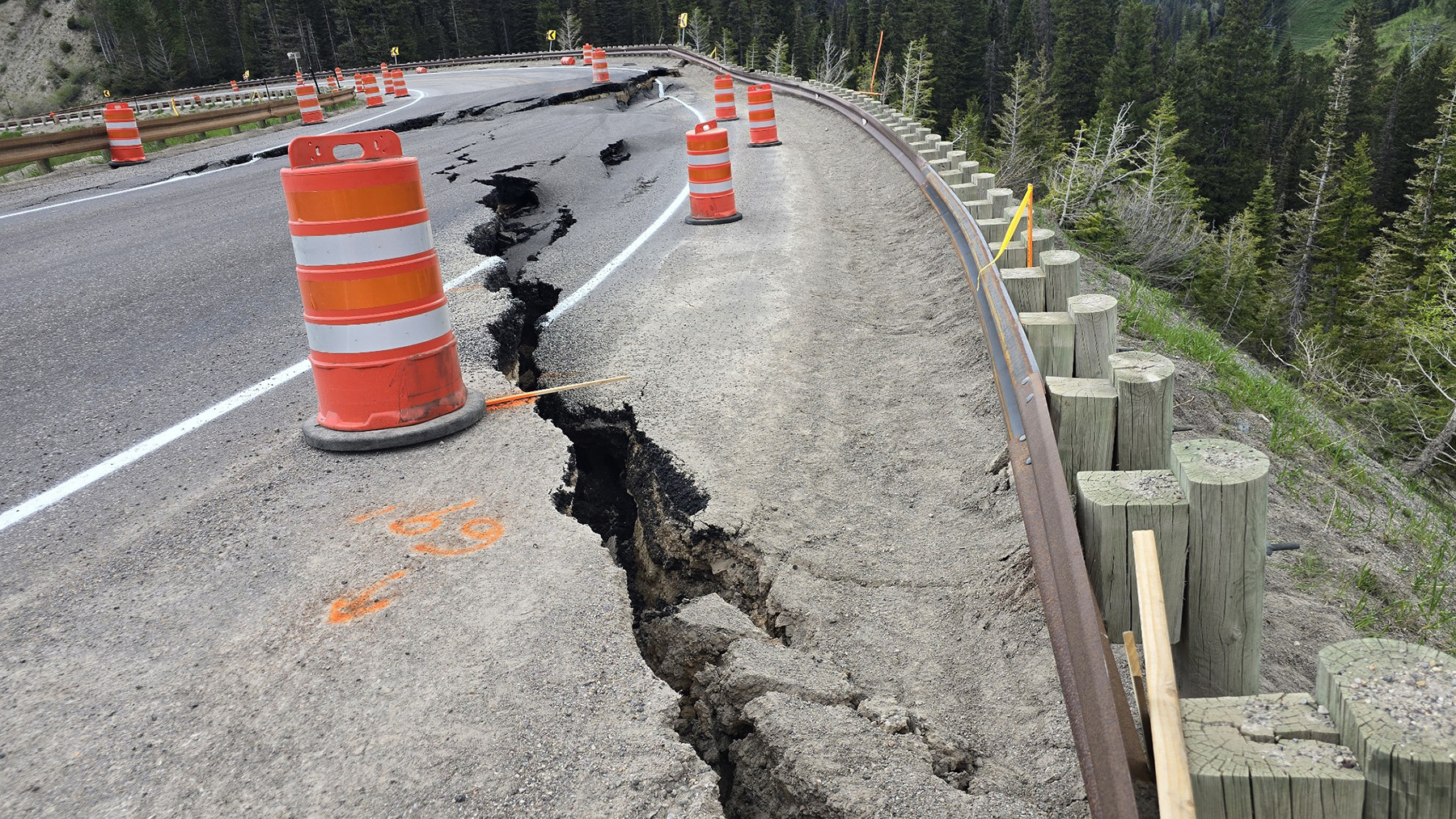
As the failure of the embankment progressed and the roadway pavement began to exhibit distress and cracking, it became obvious that failure was imminent and that no mitigation solution would be viable or safe to initiate at that time. Once the embankment failed, rebuilding it became known as the “Big Fill” project.
Teton Pass is one of the few highway corridors between Jackson and Victor, and it is a lifeline for the area’s tourist community. WYDOT worked quickly to build a detour, which was completed in three weeks, and to begin design and construction on the new embankment, enabled through the construction manager/general contractor method.
Why did it collapse?
When embankments constructed from natural subsoils fail, it is not typically due to a single event; rather, many contributing factors lead to one final event that ultimately triggers the collapse. In the case of the Big Fill, the combination included:
- Surface drainage features.
- Subsurface geological structures.
- Snowpack conditions just prior to the failure.
- Precipitation conditions and air temperature effects (final triggering mechanism).
The embankment was constructed in the late 1960s. Its base was built within a shallow drainage channel that dipped downhill and downslope away from the fill. It was not until the 1980s that the detrimental effects of historical drainage basins, which tend to concentrate water flow even after construction of new fills, were fully understood. Drainage protocols are now designed to ensure that the groundwater effects are mitigated and that the bases of fills and structures are not saturated by water.
When fills are placed, they are typically designed to be compacted at an optimum moisture content. The moisture content of clays within an embankment changes over time, and an increase in water saturation reduces the internal strength of the fill material. The design lifespan of embankment fills is not infinite; instead, it resembles that of a bridge or retaining wall, with the asset degrading over time.
Geologically, the base of the Big Fill sits between parallel east-west thrust faults that are not active. The thrust faults created a geological bench that is composed of a Cretaceous-age clay material that is known to possess lower shear strength when wet. Also, the orientation of the thrust faults created a condition in which groundwater moving along the fault was concentrated at the base of the existing fill.
Another contributing factor to the collapse was the snowpack, which is a vital feature in the Rocky Mountain West not only for ski areas but also as a water source for most of the arid West. At that time in early June, the snowpack on Teton Pass was relatively thick, creating a condition in which the snowpack would melt quickly if the daytime and nighttime temperatures were to increase rapidly. This would create a situation in which great quantities of surface water from melting snow would infiltrate the ground, raising groundwater and stream levels.
And that is exactly what happened in early June: The combination of increased daytime and nighttime temperatures, along with a rapidly melting snowpack and heavy rainfall, ultimately triggered the collapse.
The detour and rapid geotechnical investigation
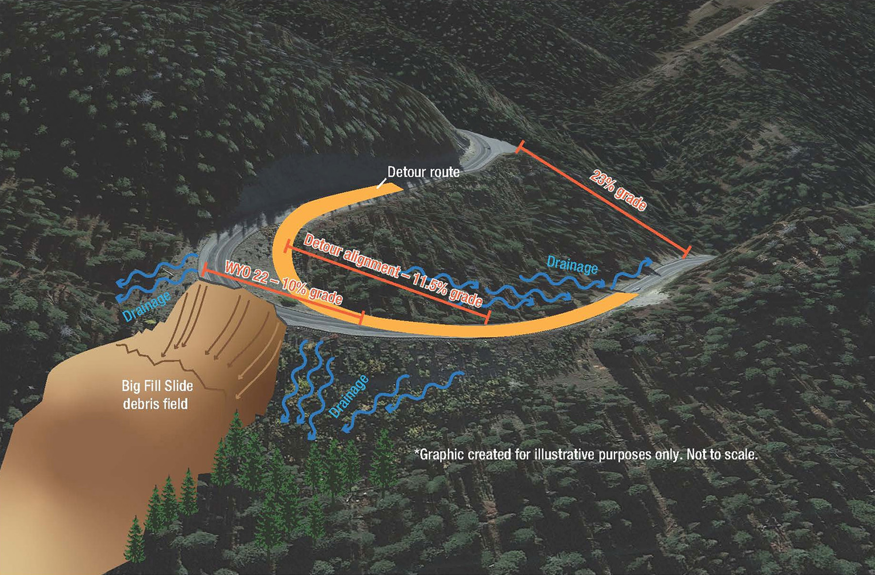
As a result of the failure, it was imperative to establish a temporary detour over Teton Pass to alleviate commuter stress and restore the roadway for peak tourism season. WYDOT contracted with Evans Construction to immediately begin building the detour. The proposed detour route was inside the failure, which included a tight hairpin curve at an approximate grade of 12%.
WYDOT brought on RJ Engineering & Consulting, a firm that specializes in the evaluation and mitigation of geohazards such as landslides, rockfalls, and debris flows, to assist with the emergency mitigation project, including analysis of temporary detour fills and permanent slide remediation. In addition, RJ worked in tandem with WYDOT Geology to provide geotechnical design services and mitigation options for repair.
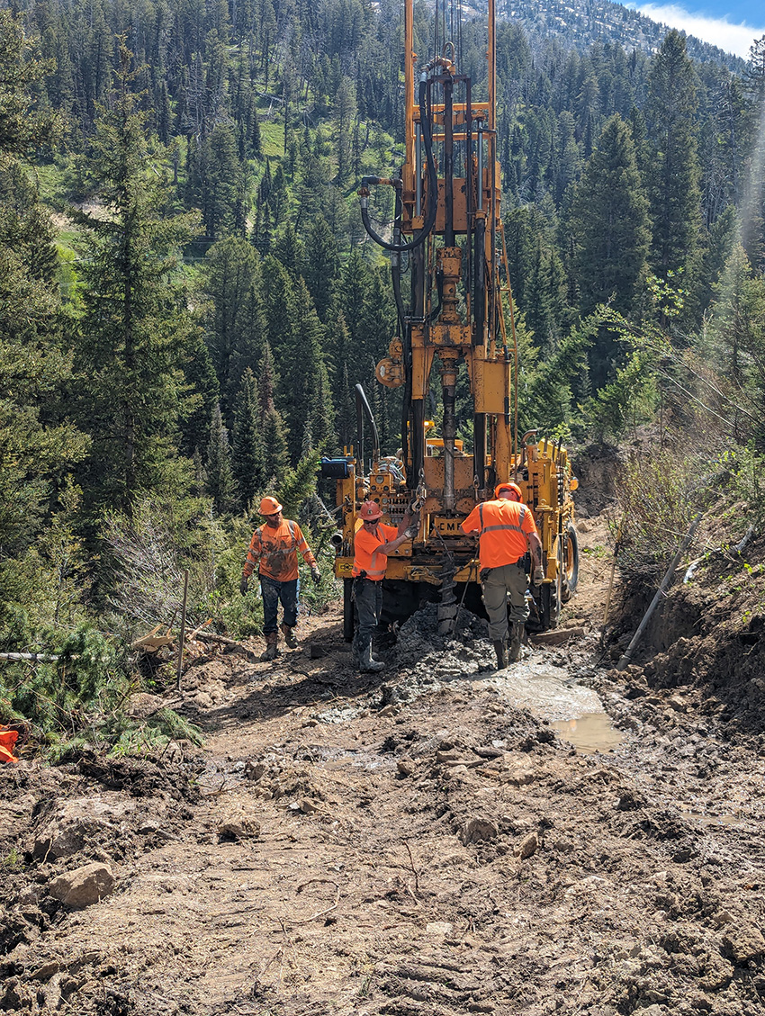
Immediately after the embankment failure, WYDOT began round-the-clock operations that included:
- Eighteen boreholes for site characterization and laboratory sampling.
- Installation of conventional inclinometers and piezometers.
- Aerial and lidar surveys.
- Geotechnical analysis of the proposed detour.
- Detour road design.
- Installation of side-scanning ground radar supplemented with InSAR (interferometric synthetic aperture radar) data.
Additionally, WYDOT contracted with AssetAssurance Monitoring to provide 24-hour instrumentation surveillance, which also included implementation of a trigger action response plan, which would provide immediate alerts to Wyoming Highway Patrol for road closures and evacuation notices to workers.
With continuous operations, the detour was completed in a little over three weeks after the failure, providing much-needed relief to the traveling public and local businesses.
Permanent repair monitoring systems design
To ensure driver safety, RJ suggested a real-time performance-monitoring system for the temporary detour and overall construction of the new embankment. That included WYDOT hiring Chinook Landscape Architecture LLC to provide drone mapping of the failed embankment to obtain detailed topography.
This measure was undertaken to rapidly generate scaled cross sections, which were invaluable for assessing global stability and ongoing design work.
WYDOT Geology installed numerous inclinometers to measure lateral movements below ground. The system consisted of conventional inclinometers requiring manual readings and shape arrays that enabled real-time readings. WYDOT Geology also installed telemetry piezometers to monitor groundwater levels within the embankment in real time.
Embankment design process
WYDOT chose the CM/GC method to expedite the design and construction of the new structure. RJ suggested this contracting mechanism because it had been involved with other large emergency projects for which the process worked well. This was WYDOT’s first attempt at CM/GC; therefore, WYDOT contracted with RJ’s subconsultant, Dyer Engineering Consultants, to guide it through this process.
The CM/GC process established a partnership among the general contractor (Ames Construction), the owner (WYDOT), the designer (RJ), and various subcontractors. To collaborate effectively, the contractor was involved during design review, costing, and scheduling throughout the design and construction processes.
Based on initial team planning between WYDOT Geology and RJ, fundamental design criteria were proposed to address the failure, and a matrix of various mitigation options was developed prior to and during the CM/GC process.
WYDOT Geology selected design criteria early on that exceeded its minimum standard for secondary roads. These selections were due to commuter detour time (which more than doubled for some commuters), fill height, and local community and tourism disruptions. The following were the criteria selected:
- The global and compound factor of safety for slope stability of the new embankment was to be 1.50 or greater.
- The design was to involve a robust groundwater drainage system.
- The embankment service life was to be 50 years or more.
- The final design was to allow for a contract completion date of November 2024.
The matrix of mitigation solutions required evaluating numerous lightweight fill options. A target unit weight for the fill was selected to minimize foundation improvements that would have delayed the construction schedule, but the fill had to be heavy enough to alleviate buoyancy concerns. The team assessed lightweight cellular concrete, foamed glass, expanded lightweight shales, native backfill, pumice, and geofoam. Only two of those met the site conditions, constraints, construction requirements, and design criteria: lightweight cellular concrete and foamed-glass aggregate.
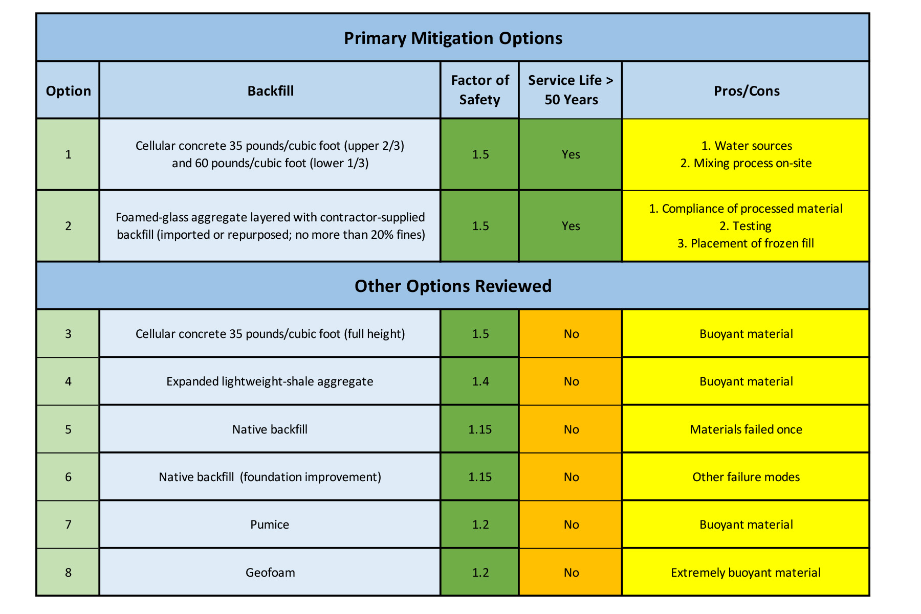
The primary concern with the cellular concrete option was the need for a significant amount of on-site water to produce the material. As the project was approaching winter, this was considered problematic. A second concern was that there were unknown water sources at the site that would have required a water well, which has other permitting/time requirements that could have delayed construction.
The main issue regarding foamed-glass aggregate was that the product is shipped from Florida. Shipping large quantities of material requires rail transport and much handling of the material. Also, the foamed-glass aggregate was too light by itself, and in order to meet the target unit weight, it would need to be layered with conventional fill material. Compaction efforts for conventional fill can be more complex in the winter.
Embankment construction
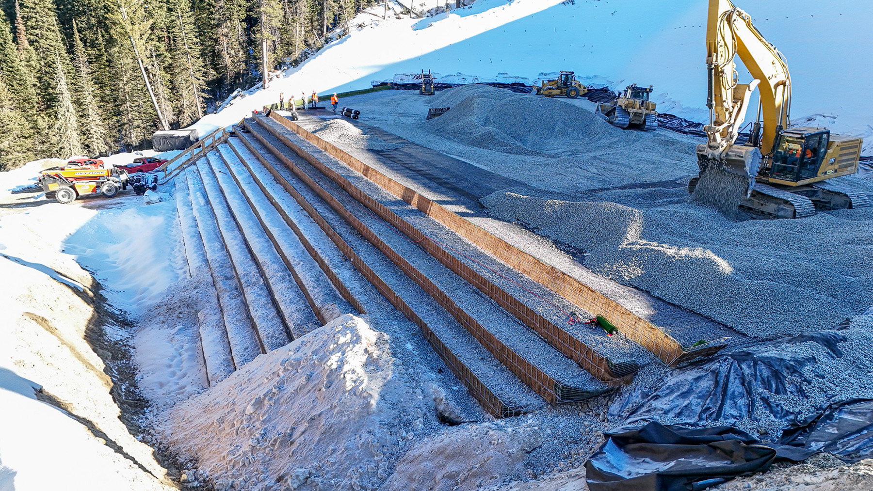
Through the CM/GC process, the foamed-glass aggregate layered with conventional backfill was selected. The backfill was sourced from adjacent rock cuts consisting primarily of limestone and dolomite. The design that RJ formulated encompassed a 2 ft vertical wire basket with geogrid and filter fabric materials throughout the fill: alternating two lifts of foamed-glass aggregate with two lifts of conventional backfill.
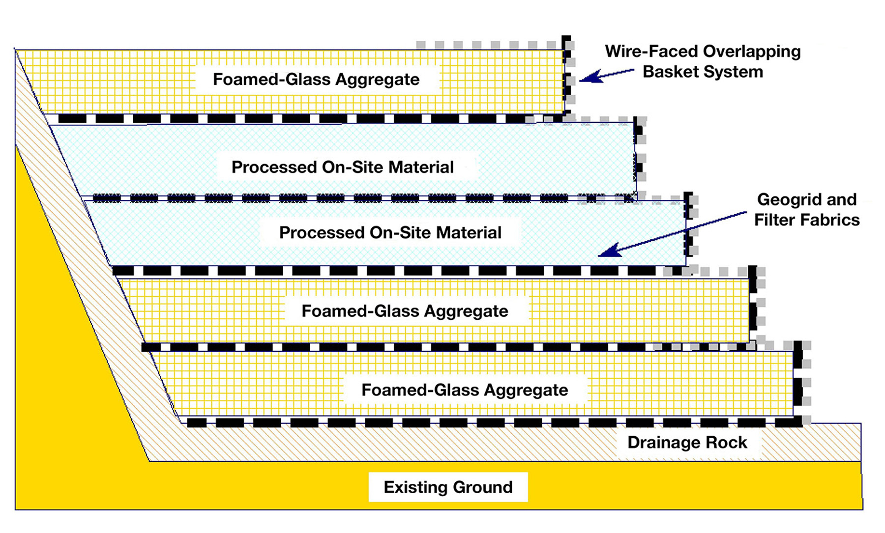
The design called for a 3 ft thick drainage system with cobble-sized rounded rock (slide stabilization rock) on the entire back side and underneath the embankment fill with horizontal drains to ensure groundwater would flow more easily from the system.
Although the original target date was November 2024, as construction progressed, it became clear this was not achievable. As part of the CM/GC process, a target backfill elevation was agreed upon, which ensured detour stability through the following spring runoff season.
Once the target backfill elevation was achieved, WYDOT bolstered the detour route for winter travel by placing a wearing course and installing a flexible guardrail to minimize snow-drifting concerns. Winter finally shut down production, as snow removal and frozen materials interfered with construction, but instrumentation monitoring continued throughout the shutdown and through project completion.
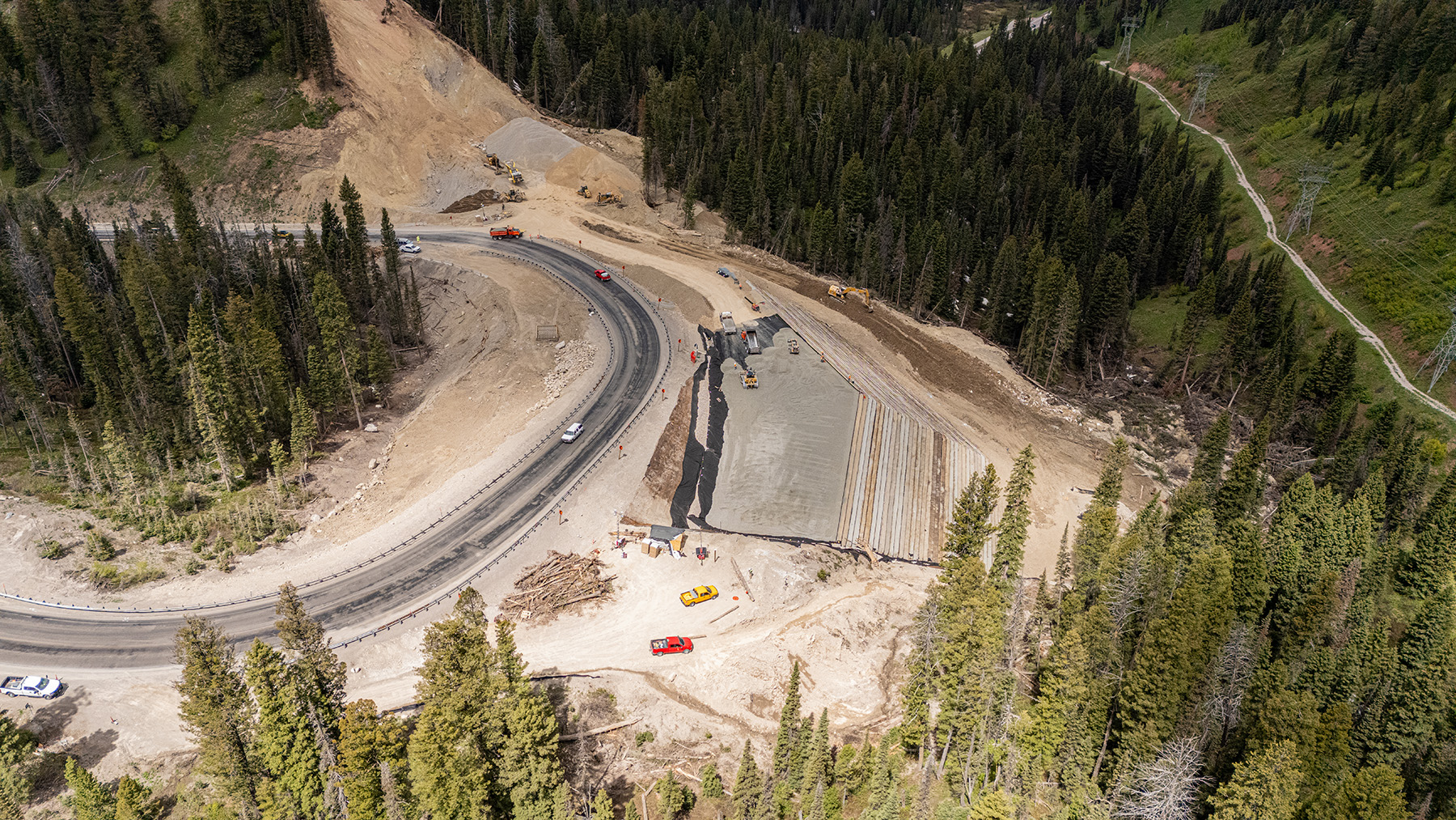
Construction resumed in April 2025, and the new embankment was completed in July. Various stakeholders were invaluable to WYDOT, including the U.S. Forest Service Caribou-Targhee National Forest; Evans Construction; Ames Construction; the towns of Jackson/Wilson, Wyoming, and Victor/Driggs, Idaho; and the Idaho Transportation Department.
Key insights
One important lesson is that the contracting method should be managed by those who are well supported in this type of design and construction process and who are adaptable to the rapid pace of a project. Another aspect worth noting is that corridor assets — whether walls, bridges, or embankment fills — are prone to weathering and rapid changes in subsurface conditions and stability.
For the Big Fill project, the teamwork displayed among RJ, WYDOT, and WYDOT Geology was phenomenal, and the willingness to pitch in as much time as needed to meet the demands of the project was critical to its success.
Ben Arndt, P.E., M.ASCE, is a principal and vice president for RJ Engineering and Consulting Inc. in Evergreen, Colorado.
Richard Johnson, P.E., is a principal and president of RJ Engineering and Consulting Inc. in Silt, Colorado.
James Dahill, P.G., is the chief engineering geologist with WYDOT Geology in Cheyenne, Wyoming.
Jeff Booher, P.E., is an assistant chief geotechnical engineer with WYDOT Geology in Cheyenne, Wyoming.
Seth Wittke, P.G., is a principal geologist with WYDOT Geology in Cheyenne, Wyoming.
Project credits
Owner
Wyoming Department of Transportation
Detour construction
Evans Construction, Jackson, Wyoming
Geotechnical design services
WYDOT Geology, Wyoming
RJ Engineering and Consulting, Silt, Colorado
Instrumentation monitoring
AssetAssurance Monitoring, Fishers, Indiana
Construction manager/general contractor
Ames Construction, Burnsville, Minnesota
Aerial lidar and photogrammetry mapping
Chinook Landscape Architecture LLC, Centennial, Colorado
CM/GC specialty consultant
Dyer Mountain Engineering Ltd., Lakewood, Colorado
This article first appeared in the May/June 2026 issue of Civil Engineering as “The Big Fill.”


