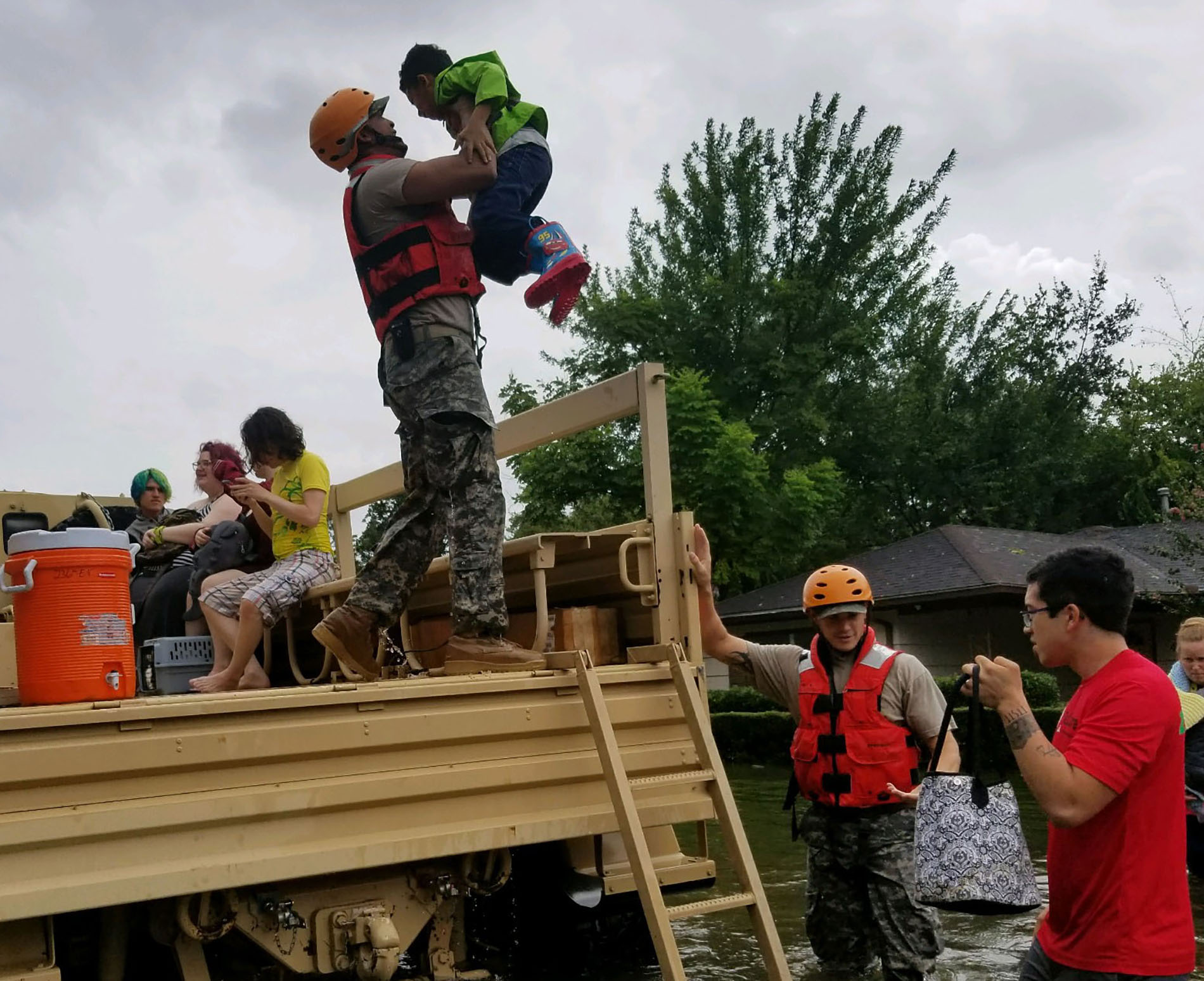
 1st Lt. Zachary West, U.S. National Guard
 With the Atlantic hurricane season beginning June 1, this is the second in a multipart series looking at how engineers are making communities safer and infrastructure more resilient as storms grow stronger and more frequent. Read part 1, here.
As Carol Haddock prepared for a trip out of the country in August 2017, a fragmented storm system was moving westward across the Atlantic Ocean.
Forecasters labeled it “disorganized” and weren’t certain whether it would become a hurricane. Haddock, MPA, P.E., F.ASCE, then Houston’s acting director of public works, met with the mayor to discuss potential risks and whether she should move forward with her impending visit to New Zealand and Australia. In the end, the storm appeared manageable, so the mayor told her to get on the plane, and Haddock, ASCE’s current president-elect, did.
Further reading:
- Engineering for hurricanes: Modeling bolsters mitigation as Atlantic season begins
- How Florida’s Babcock Ranch survived Hurricane Ian
- Community resilience starts with people
Within a week, the formerly benign-looking storm developed into Hurricane Harvey and struck southeast Texas, killing scores of people, inflicting more than $100 billion in damages, and flooding tens of thousands of homes.
Time has shown that predicting what hurricanes will do next is nearly impossible. But predictions are ever-present when it comes to the storms, and the 2026 Atlantic hurricane season, which opens June 1, is no exception.
The National Oceanic and Atmospheric Administration’s newly released outlook points to a below-normal season. NOAA’s National Weather Service forecasts eight to 14 named storms, including three to six hurricanes. By comparison, an average season produces 14 named storms, including seven hurricanes.
Haddock, a professor-in-the-practice of civil and environmental engineering at Rice University and director of public works and engineering for Baytown, Texas, a Houston suburb, vividly remembers the uneasy days before Harvey struck, the multihemisphere coordination of emergency efforts during the event, and the city’s push for regulations after the storm.
Harvey heads for Houston
Before evolving into a menacing hurricane, the storm spent most of its lead-up to landfall in chaos as it passed through the Caribbean and into the Yucatan Peninsula.
“There were two tracks at the time: One that had it pushing through San Antonio and kind of fizzling in the Hill Country,” recalled Haddock, whose planned trip included a talk at a conference. The other prediction had the storm colliding with a weak weather front coming from the north – Harvey would then be pushed back toward the coast. “They were predicting 15 to 20 inches of rain; 15 to 20 inches of rain is a lot, but in Houston, it's not unheard of,” she said.
 Jason Dixson Photography
Even the National Hurricane Center thought Harvey was likely to remain at tropical storm strength.
On the morning of Wednesday, Aug. 23, experts noted that its path across warm Gulf of Mexico waters could raise the system to either a strong tropical storm or a Category 1 hurricane when it made landfall in Texas. By Thursday, it was becoming clear that all previous predictions had woefully underestimated Harvey.
On Friday afternoon, Harvey quickly reached Category 3 and then Category 4 intensity and was set to produce devastating winds of more than 130 mph and heavy rain. Compounding the threat, a predicted cold front met Harvey head-on, stalling its progress and settling the system over Houston.
By the time Haddock landed in New Zealand, Houston was being hit hard. She spent the next two weeks attending meetings virtually, keeping an eye on developments from the other side of the world. Ironically, her conference talk was on measures the city was taking to improve stormwater quality. She rewrote her original talk, condensing it so she could add 15 minutes to discuss Harvey.
“The confession part of it: We weren’t expecting the devastation that we experienced. That doesn’t mean we weren’t prepared,” Haddock said. Although the city can “handle” 20 inches of rain, the Houston team knew that flooding would occur. Staffing was boosted, high-water rescue was at the ready, and coordination with police and firefighters was underway.
But the 50-plus inches of rain that actually fell on Houston was vastly different from 20.
“The first thing that you begin to see is the roadways become inundated,” and access starts to be cut off, explained Haddock. “In smaller storms, that becomes important because people who are cut off are physically and emotionally stressed and may need medical support.”
As waters rose, so did panicked calls from residents – 911 was overwhelmed, and the emergency operations center was inundated.
In the operations center, it was controlled chaos. The Harris County incident commander was triaging as reports came in. Those reports went analog following widespread power and network outages.
“They had a wall in the center where they wrote general geographic regions,” Haddock said. “They were using Post-it notes, putting names and addresses on regions.” The team would then identify crews nearby and deploy them to those in distress.
“I mean, it feels like chaos, but it also feels like you've got people in the room who are like, ‘All these other things are broken – here's how we're going to tackle it,’” she said. Everyone in public works was reassigned to emergency response and got new assignments. Fire engines and dump trucks became rescue vehicles or food and water delivery trucks, sometimes driving through 5 feet of water.
Real-time data also helped guide responses.
“Harris County Flood Control District has an amazing gauge network with rain gauges and flow depths – as long as they have not been washed away,” Haddock said. The team also got precipitation data from radar systems and data from the National Weather Service and StormGeo. All this data was confirmed by teams on the ground throughout the city. “I love automated data, but sometimes you’ve got to touch it and feel it,” Haddock said.
Aftermath and preparing for next storm
When the rains finally stopped, the scale of damages was profound. During the storm, Haddock said that 52 inches of rain fell over Houston. In total for southeast Texas, 14 trillion gallons of rain fell. In comparison, Houston treats and distributes 160 billion gallons of water over the course of a year.
Harvey caused about $160 billion (adjusted for inflation) in damages – ranking it second only to 2005’s Katrina. During the event, 89 people died, more than 30,000 people were displaced, and over 200,000 buildings were damaged.
Wastewater treatment infrastructure was also damaged, putting residents in an unsafe water situation. One of the basins in the northeast plant was underwater, making the treatment process nonfunctional. In the basins, there are millions of bacteria that act as cleaning agents for wastewater treatment.
“You’re letting nature – in a controlled, biology experiment – basically eat the waste and the organics, which cleans the water,” Haddock explained. But when a basin floods, it takes all the bacteria with it.
“All those bugs you’ve been spending years growing? All washed out,” she said. Getting the system online is a complicated and time-consuming process – the plant needs to be dried out, bacteria collected from unaffected plants, and the bacteria need time to grow back to functional, stable numbers. “It can take anywhere from a week to a month,” Haddock noted.
Haddock added that flooding can cause big problems for coastal water treatment plants. But storm surge damages are an even bigger threat, she said.
“There’s two different issues there: One is all the stuff that’s in it could get washed out,” she said. “But the other is that the storm surge is such a powerful thing that it can literally damage the basins, the equipment.”
For instance, during Hurricane Ike, a 2008 storm that also hit Texas, Galveston’s water treatment plant was damaged by storm surge.
Haddock was considering all these factors while in New Zealand, where she met with colleagues to discuss how to move forward after a community-altering natural disaster. In particular, she wanted to understand how they approached recovery after the tragic 2011 earthquake in Christchurch. What they said surprised her.
“(One colleague) said, ‘Carol, you have 18 to 24 months to make any changes in policy,’” she said. “‘You have three years to start projects because by five years, people will have forgotten the disaster.’”
So when she returned home, she got started.
She immediately tackled something that was unrelated to infrastructure: the safety of her crew. When the teams came back into the office to attend the after-action debriefing, Haddock was horrified to learn about one specific danger: some of her deep-water rescue team members didn’t know how to swim.
“I was scared for their safety,” she said. She established voluntary (paid) swim lessons for all team members – a move that was criticized at the time, but she stands by it.
The team also knew it had to prepare for future storms with increased rainfall. One big change was the transition from NOAA’s Atlas 14 – long the standard for U.S. infrastructure design – to the newer, preliminary Atlas 15 precipitation estimates. While Atlas 14 relies on historical data, Atlas 15 incorporates anticipated future climate projections. (Atlas 15 is moving closer to publication.)
In the Atlas 14 estimates, Texas based its 100-year floodplains on 14 inches of rain in 24 hours. In comparison, Atlas 15’s 100-year floodplains have rainfall totals of 17 inches in 24 hours, explained Haddock.
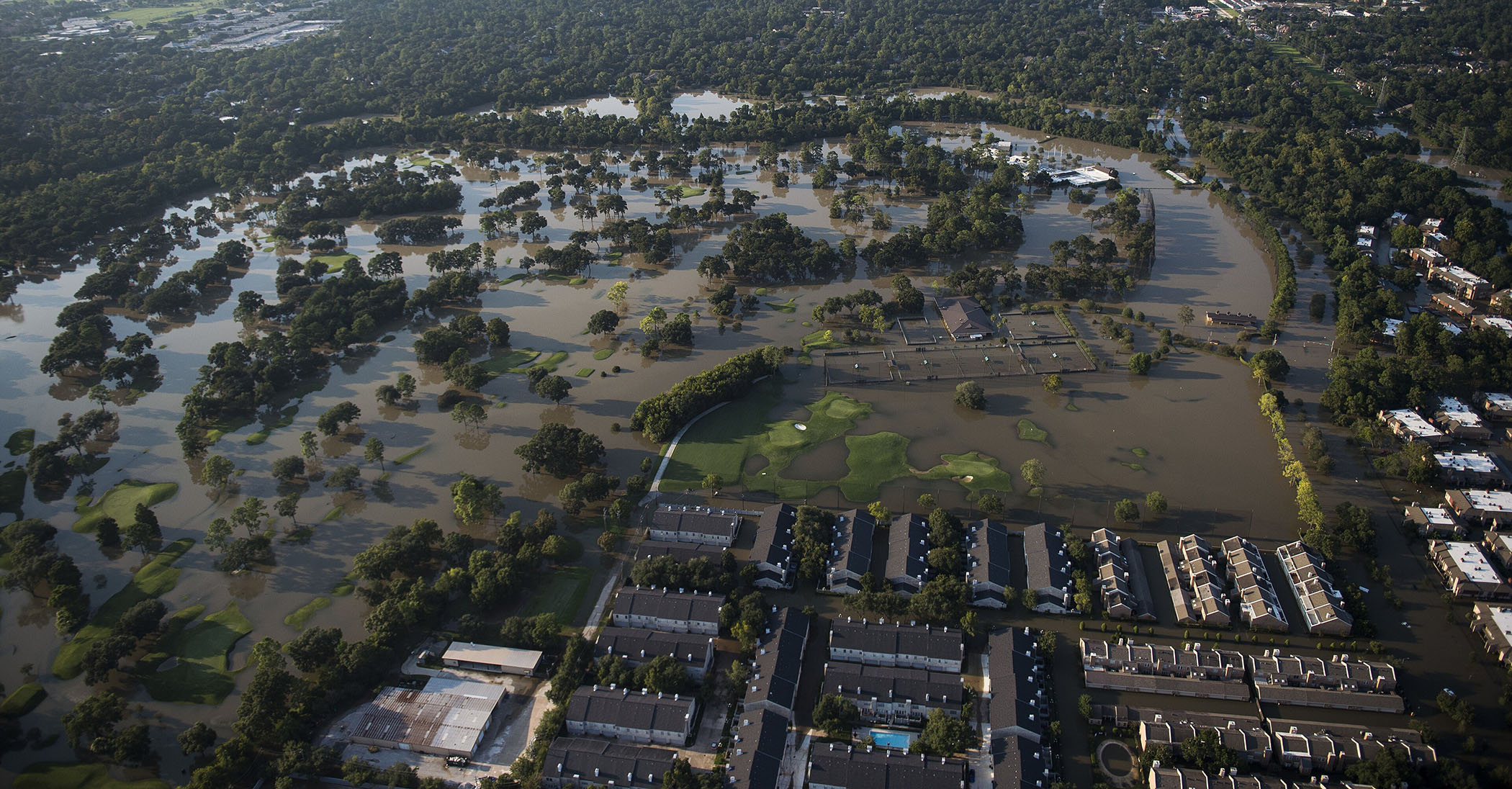 U.S. National Guard via Wikimedia Commons
 “If you go back and look at our current maps, the 500-year floodplain was drawn with about 17 inches of rain,” she said. A year after Harvey, she and the city’s chief resilience officer pushed to adopt a regulation with a 500-year floodplain plus 2 feet of freeboard – a mandatory elevation buffer above predicted floodwaters – for new structures.
In their analysis, Haddock noted that adopting the regulation for a 500-year floodplain plus 2 feet would have allowed 84% of Harvey-flooded homes to avoid that fate. The team succeeded in pushing the regulation through but not without criticism.
“We had developers show up en masse,” Haddock said. They argued that adding the new regulations would spike housing costs and prevent new residents from moving to the city. Haddock noted that in Houston, the fourth-most-populated U.S. city, housing still feels solid, despite more robust regulations.
Considering that some areas of Houston experienced 1,000- to 2,000-year floods in a 24-hour period during Harvey, more robust regulations make sense. And Harvey was not an anomaly.
“To me, the most alarming thing is that Harvey didn’t take all our records,” said Haddock. “Tropical Storm Allison (which struck Houston in 2001) still has the six-hour, the 12-hour, and the 24-hour record of the most rain.”
Haddock said that while many describe Harvey as exceptional, she knows this level of storm is not unique. “Another Harvey-like event will happen again in my life.”