By Debbie Ferraro, P.E., M.ASCE
In Philadelphia, the I-95 CAP project at Penn’s Landing is redefining urban infrastructure and reuniting a city with its waterfront.
For generations, Philadelphia’s identity has been inseparable from the Delaware River. The waterfront served as the city’s front door, supporting commerce and civic life while anchoring neighborhoods to a shared natural asset. Then the 20th century reshaped the space, as dredging and large municipal piers pushed the area toward heavy industry. Although the manufacturing boom eventually declined, the construction of Interstate 95 severed the riverfront from the Center City area, creating a physical and psychological divide that persisted for more than four decades.
Today, that divide is finally being repaired.
The I-95 Central Access Philadelphia project at Penn’s Landing represents one of the most ambitious urban infrastructure efforts in the city’s modern history. Rather than focusing solely on replacing aging assets, the project is framing infrastructure renewal as an opportunity for civic repair and restoring access between a city and its waterfront.
Created in conjunction with the construction of I-95, Penn’s Landing lies along the Delaware River and is home to the Independence Seaport Museum, historic warships, an ice rink, and several seasonal parks. But the largest public space, the Great Plaza, was an outdated venue that had been paved over, with no tree canopy and limited connections to adjacent properties or the city neighborhoods. Penn’s Landing also suffered from significant grade changes that required long, stair-heavy access routes, making it difficult to reach and unfriendly for strollers, cyclists, and people with disabilities.
Although an existing 2-acre structure with a park spanned I-95, that crossing was nearing the end of its useful life. This created an opportunity to expand and reconfigure that original “cap” structure, as it was known, to strengthen multimodal and visual connections to the river and advance the goals of a master plan for the region.
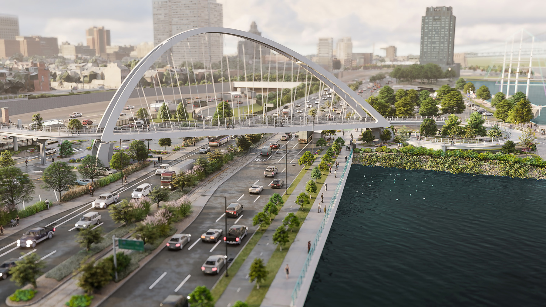
The I-95 CAP project will remove the aforementioned obstacles (grade changes and access issues) and create a new civic destination along the river. It will do so by replacing and expanding the existing cap structure with a larger cap that spans I-95 and extends east over Christopher Columbus Boulevard as well, improving pedestrian and multimodal access between Center City and the waterfront. The new cap will include roughly 5 acres of space on the structure over I-95 and the adjacent arterial roadway and roughly 6 acres of space to the east of the site of the former Great Plaza, which will gently slope to the river’s edge, creating an overall 11.5 acres of new green space.

In addition, the South Street Pedestrian Bridge over I-95, which originally terminated on the east side of the highway, will be replaced with a new signature structure — a tied-arch bridge that will extend over Christopher Columbus Boulevard.
The $429 million effort is a partnership among the Pennsylvania Department of Transportation, the Federal Highway Administration, the city of Philadelphia, and the Delaware River Waterfront Corporation. Work began in 2023 and will continue in phases through the end of the decade. Since 2016, Pennoni has served as the prime design consultant for this landmark initiative, helping translate a bold civic vision into a technically sound, constructable, and resilient reality. The result is a project that blends engineering innovation with placemaking, sustainability, and collaboration, setting a new standard for how cities can reclaim their waterfronts.
Community goals
Across the United States, many cities are grappling with the legacy of mid-20th-century highway construction. Built to prioritize vehicle throughput and regional mobility, many urban highways fractured neighborhoods, displaced residents, and cut cities off from their waterfronts and other major sites. Engineers and planners are increasingly being asked not only to replace deteriorating infrastructure, but also to rethink the relationship of these roadways to the urban fabric.
The foundation for this approach was established with the 2011 Master Plan for the Central Delaware River Waterfront, developed by the DRWC. That plan articulated a clear goal: to reconnect Philadelphia’s neighborhoods to the river through targeted infrastructure investments and a continuous network of parks and trails. These ideas became key elements in the I-95 CAP project.

From the outset, however, Pennoni and its partners understood that the project’s success would depend on more than technical performance. The new structure needed to feel like a natural extension of the city. Achieving that goal required close collaboration among engineers, planners, architects, and landscape designers to make sure that structural decisions supported, rather than constrained, the public realm vision.
Active interstate
At the heart of the I-95 CAP project is the new cap structure itself, which extends north from Walnut Street to Chestnut Street and east from Front Street to the river. It is part of the overall new landscape designed to restore visual and physical connections between the city and the waterfront.
Supporting a large park above one of the region’s busiest highways posed significant engineering challenges. The structure needed to provide vertical clearances of more than 17 ft above the tracks of an active rail line known as the Delaware Avenue Extension. The project also had to provide more than 16 ft of vertical clearance above the I-95 roadway and the adjoining ramps while also accommodating soil depths on the cap structure to support the landscaping and integrate utilities and drainage.
Pennoni’s solution was a slender structural design using steel-plate girders with post-tensioned reinforced-concrete planting troughs between girders. Moreover, the project also reduced the number of piers for the cap structure from four on the original structure to just two for the new crossing and reduced the number of spans from four to three. This provides PennDOT with flexibility for any future reconfigurations of the highway.
The new cap structure is more than 600 ft wide and spans more than 360 ft across I-95, the access ramps, the active rail lines, and Christopher Columbus Boulevard. Its scale required careful attention to constructability, load paths, and redundancy.
For constructability, the girder splice locations were selected to balance multiple factors, including proximity to points of contraflexure and the most advantageous locations for girder placement. Because the team determined that construction from west to east would be most efficient with access and traffic control limitations, one of the splices was located over Christopher Columbus Boulevard to reduce impacts to I-95. It was also determined that the first girders could be placed while substructure units at the far end of the new cap were still being constructed in order to save time in the schedule and reduce storage costs.
For load paths, the non-uniform load profile on the structure caused higher-than-usual transverse forces, which required modeling and analysis of the intermediate diaphragm members. These members are non-skewed structures that typically serve as secondary elements for stability but become primary members at select transverse load paths and thus require higher-grade materials to efficiently handle the applied forces. For redundancy, the design team coordinated with the landscape architect to locate concrete troughs to support the anticipated tree layout while in turn being supported between girder groups.

Difficult ground
The long-term performance of the new cap structure depends on conditions below grade where variable soils, floodplain constraints, and settlement risks required equally innovative engineering solutions.
Portions of the site featured compressible soils, raising concerns about settlement under the weight of traditional fill and park features. To address this challenge, Pennoni — in consultation with the geotechnical engineer, American Geotechnical & Environmental Services Inc. — incorporated more than 80,000 cu yd of ultra-lightweight foamed-glass aggregate as structural fill, which represents one of the largest applications of this material worldwide. The lightweight fill significantly reduced loading on underlying soils while maintaining structural performance.
To further manage settlement risk, the design included pre-consolidation periods, load-transfer platforms, and deep foundations for key structures such as a mass-timber building. The cap substructure employed a variety of foundation types tailored to site constraints. These included retrofitting and reusing an existing reinforced-concrete abutment at Front Street, new concrete wall piers supported on drilled caissons socketed into bedrock, and a new abutment on the east side of the site supported on concrete-filled pipe piles within the 100-year floodplain. Throughout the design phase, Pennoni coordinated closely with utility owners and other stakeholders to avoid conflicts with major infrastructure, including large sewer systems and rail lines.
At PennDOT’s request, earth pressure cells — sensors that monitor pressures at the interface of structures and soil — were incorporated to assess long-term performance of the lightweight fill, providing valuable data on creep and settlement that will inform future infrastructure projects nationwide.
Keep moving
Replacing aging infrastructure over an active interstate demanded a construction strategy as deliberate as the design itself. Pennoni developed detailed maintenance- and protection-of-traffic plans, staging strategies, and regional traffic models to ensure I-95 could remain operational throughout most of construction. In a first for Pennsylvania, however, PennDOT approved full-weekend closures of I-95 to enable rapid demolition of the existing cap structure. Each closure lasted approximately 35 hours and allowed the demolition work to be completed safely and efficiently, significantly reducing overall construction duration and minimizing long-term disruption to surrounding neighborhoods.
Community engagement played a critical role in this approach. Residents adjacent to the project expressed their willingness to accept short-term disruption in exchange for a faster construction schedule, which reinforces the value of transparency and collaboration on large urban infrastructure projects.

Beyond the CAP
Reconnecting the city to the waterfront will require more than a single structure. The success of the new, larger cap depends on how well it integrates with surrounding transportation networks, pedestrian routes, and public spaces at multiple elevations.
Complementing the cap structure is the extension of the South Street Pedestrian Bridge, which will provide access across Christopher Columbus Boulevard into the Marina Basin. This project involves the addition of an asymmetrical tied-arch bridge that balances structural efficiency with visual impact.
The new 80 ft high bridge section will measure more than 611 ft long with a 258 ft main span to carry pedestrians and cyclists over a six-lane roadway and active rail lines, creating a safe, direct connection to the waterfront. Pennoni and its subconsultant, WSP, used advanced 3D modeling, wind and vibration analyses, and visualization tools to refine the design and integrate the bridge seamlessly into the surrounding landscape and trail network.
Beyond the bridge itself, the I-95 CAP project will reshape the surrounding street network to prioritize safety, accessibility, and multimodal travel. Planned improvements include completion of the Delaware River Trail along Christopher Columbus Boulevard, a dedicated cycle track on the Chestnut Street Bridge, widened sidewalks, raised pedestrian crossings, and traffic-calming streetscape elements along Front Street.
Special attention was given to the space beneath the new cap structure. DRWC requested enhanced lighting and a streetscape design that would make walking or biking under the structure as safe and welcoming as traveling across the park above, solidifying the idea that infrastructure should enhance, not diminish, public spaces.
Rather than a standard concrete barrier, the separation between the trail and the roadway is designed as a sculptural element, with flowing curves that replicate the shoreline of the Delaware River. Integrated specialty lighting enhances safety while creating a strong sense of place for pedestrians and cyclists using the trail at night.

CAP coordination
Delivering the I-95 CAP project required unprecedented coordination among agencies with distinct missions, funding sources, and operational responsibilities. PennDOT, the FHWA, the city of Philadelphia, and the DRWC played essential but different roles in advancing the project, necessitating a collaborative framework that extended well beyond traditional transportation delivery models.
PennDOT served as the owner and steward of the interstate infrastructure and acted as the client for the federally and state-funded components of the project. As a result, the cap structure, roadway interfaces, and traffic operations were subject to rigorous federal oversight, environmental review, and design standards. In parallel, the city of Philadelphia and the DRWC led the vision, programming, and delivery of the public realm above the highway, supported by city and private funding sources.
As the prime design consultant, Pennoni functioned as an integrator — aligning technical requirements, regulatory constraints, and design intent across agencies. Regular coordination meetings, shared modeling environments, and iterative design reviews were critical to resolving conflicts that encompassed transportation performance, constructability, and public space goals. This integrated approach allowed engineering decisions to be evaluated not only for structural and operational performance, but also for their downstream impacts on maintenance, programming, and user experience.
The layered funding structure further illustrated the need for close coordination. Federal participation triggered extensive documentation and approval processes, while city and private funding introduced parallel schedules and priorities. Maintaining alignment across these tracks was essential to sustaining project momentum and ensuring that design decisions remained consistent across contracts and phases.
Extended stewardship
Pennoni played a central role in translating engineering realities into legal and operational frameworks. The aerial rights license agreement, for example, established the terms under which the park could occupy space above an active interstate, while the intergovernmental agreement clarified maintenance obligations, access requirements, and long-term coordination needs. These agreements were not peripheral tasks; they were foundational for ensuring that the infrastructure would remain safe, functional, and maintainable for decades.
From an engineering standpoint, these governance considerations directly informed design decisions. Access for inspection, maintenance, and future repair was integrated into the new cap structure from the beginning. Utility routing, drainage systems, and building interfaces were designed to allow intervention without disrupting highway operations, an often-overlooked requirement that becomes critical over a multigenerational lifespan.

Future proofing
While the cap structure is designed to serve today’s needs, it is equally shaped by uncertainty about the future of urban transportation. PennDOT’s long-term planning for the I-95 corridor anticipates potential reconfiguration of lanes, shoulders, and traffic management strategies as travel patterns evolve.
To accommodate that uncertainty, Pennoni designed the project’s structures to be adaptable without requiring major reconstruction, which is a philosophy that extended beyond geometry. The integration of advanced traffic management systems — including lane control signals, variable speed limits, and changeable message signs — positions the corridor to respond dynamically to incidents, congestion, and future operational strategies.
The project’s sustainability goals extend beyond conventional requirements. Nearly 5 acres of impervious surface are being converted to pervious landscape, and more than 470 trees and 56,000 plantings will be added to combat the urban heat-island effect. Stormwater runoff will also be directed to landscaped areas for natural filtration. In addition, buildings within the park and other structures are seeking LEED Platinum certification from the U.S. Green Building Council and the International Living Future Institute’s Zero Carbon certification, with designs focused on net-zero energy consumption.
Philadelphia anticipates up to a 4 ft rise in sea levels over the next 100 years, and these projections were carefully evaluated for the topside design. Fill within flood-prone areas has been minimized and designed to recover following inundation, with limited amenities placed in zones most susceptible to impact. Within the control center, mechanical equipment is mounted above floodplain elevations, and buildings incorporate floodproofing measures to enhance long-term resilience.
Lessons and conclusions
As work progresses, the I-95 CAP project, which will be publicly known as Penn’s Landing Park, is already yielding lessons for large-scale urban infrastructure delivery, particularly the importance of early public engagement and conservative funding strategies for long-duration projects.
Perhaps most notably, the project underscores how engineering teams can act as integrators — bridging disciplines, agencies, and public expectations. By balancing technical rigor with empathy for community concerns and civic aspirations, the I-95 CAP project shows how infrastructure can evolve beyond mobility to support community, sustainability, and public life.
For Philadelphia, a highway that once divided the city is being transformed into a foundation for connection, and that is a powerful reminder that thoughtful engineering can help cities heal, adapt, and thrive.
Debbie Ferraro, P.E., M.ASCE, is an associate vice president and project manager at Pennoni.
Project credits
Clients
Pennsylvania Department of Transportation, Federal Highway Administration, City of Philadelphia, and Delaware River Waterfront Corp.
Prime consultant
Pennoni, Philadelphia
Landscape architect
Hargreaves Jones, New York
Architect
KieranTimberlake, Philadelphia
Construction management
Hill International, Mount Laurel, New Jersey
Bridge design and stormwater management
WSP USA, Exton, Pennsylvania
Geotechnical engineering
American Geotechnical & Environmental Services Inc., Canonsburg, Pennsylvania
Project planning and public outreach
AECOM, Philadelphia
Survey, right of way, E&S, signing and pavement marking
Susquehanna Civil, York, Pennsylvania
This article first appeared in the May/June 2026 issue of Civil Engineering as “Reconnecting a Riverfront.”
Engineering Is a Team Sport
Big infrastructure solutions don’t just magically appear while you're sitting alone in your cubicle. Solutions take shape when you open the door to collaboration and open your mind to new ways of thinking. Solutions happen when you work as a team.
ASCE2027: The Infrastructure and Engineering Experience is a first-of-its-kind event bringing together big thinkers from all across the infrastructure space, March 1-5, 2027, in Philadelphia. Join the team and step up your game!
