Cranetown Triangulation Site
40 49 43.9 N, 74 13 27.1 W
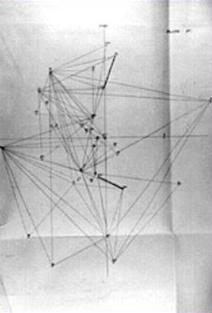
Fieldwork established the Cranetown Triangulation Site as an essential part of the first precise geodetic survey in the United States.
"In human progress within the present century there has been no greater marvel than the operations of the Coastal Survey..."
- Harper's Monthly, March, 1879
The precise system of measurements provided today by the U.S. Coast and Geodetic Survey originated with an act of Congress under the administration of Thomas Jefferson in 1807 that funded work on "an accurate chart" of America's coastal waters. Intended to aid sea-going commerce, the first work on this project, carried out in 1816 and 1817, helped establish a complex grid of geodetic reference points on which much of our land- and sea-based navigation now depends.
Directed by Swiss-born mathematician and astronomer Ferdinand Hassler, the measurements taken by the Coastal Survey, as it was then known, followed a plan of organization that continues to serve as the foundation for the activities of the U.S. Coast and Geodetic Survey today. A key reference point located in the New Jersey township of Cranetown, used to map the harbor waters of New York City, was designated an Historic Civil Engineering Landmark in 1986 to honor the pioneering work of Ferdinand Hassler and the subsequent achievements of early American surveyors.
Facts
- The U.S. Coast and Geodetic Survey -- an agency of the National Oceanographic and Atmospheric Administration -- currently maintains a grid of more than 500,000 benchmarks across America identified by small bronze markers imbedded in stone or concrete.
- Ferdinand Hassler first learned the system he applied to American surveying as a student at the University of Bern, where he worked in 1790s with his mentor, mathematician Johann Georg Talles, on a geodetic survey of the Canton of Bern.
- Although the system of U.S. Coast and Geodetic Survey reference points is considered invaluable by most civil engineers, not all builders rely on them. Surveyors laying out various stretches of the New Jersey Turnpike, for example, used inferior reference points outside the system. The result is a series of S-curves required to correct the highway's path.
Resources
- Aaron L. Shalowitz, The United States Coast and Geodetic Survey ; U.S. Department of Commerce, 1974
- Albert A. Stanley, "Hassler's legacy"; NOAA Magazine , January, 1976
- John Noble Wilford, The Mapmakers ; Alfred A. Knopf, 2000
- National Oceanic and Atmospheric Administration (NOAA)