
The Dalles Lock and Dam
 Oregon Historical Society
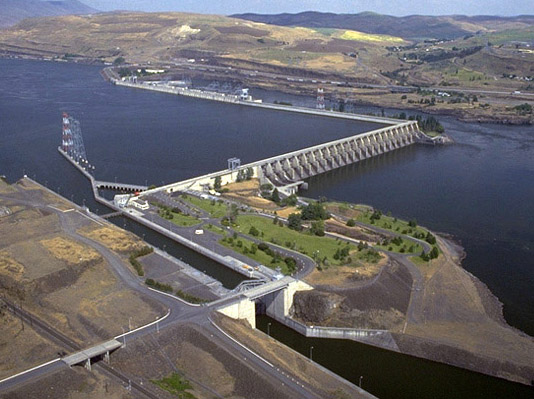
The Dalles Lock and Dam was one of the largest, most complete, and complex multipurpose projects of its kind in the United States at the time of its construction. It provided an example for future projects benefitting navigation, recreation, water for irrigation and hydropower, fish migration, and flood mitigation. The unusual "L" configuration of the project enabled reduced construction dewatering and created a permanent shallow stilling basin that aids fish passage.
The Dalles Lock and Dam is a run-of-river dam on the Columbia River approximately 192 miles upstream of the mouth of the Columbia River. Located 90 miles east of Portland, Oregon, it straddles the Oregon-Washington boundary between the Bonneville Dam and John Day Dam. The project was constructed with the primary purpose of providing hydropower and navigation to the Pacific Northwest; other benefits of constructing a new dam on the Columbia River at The Dalles also included irrigation, flood mitigation, and recreation.
At over 1.5 miles in length, The Dalles Dam is the longest dam on the Columbia River and is the sixth largest hydropower project in the United States. Designed and built by the U.S. Army Corps of Engineers, it was the third dam in a series of eight navigation dams built on the 555-mile-long Columbia-Snake River Inland Waterway. It is a composite structure composed of a series of concrete gravity structures and an earth and rockfill embankment. The dam has an average height of 130 feet with an overall length of 8,700 feet. Construction began in February 1952 and was completed in 1959.
The dam’s unique “L-shape” was borne out of a creative engineering design process that took advantage of the local geological conditions, complex topography, and the natural rock platform of the river. The distinctive shape allowed for a natural river bypass during construction which reduced river diversion costs considerably. The Columbia River at The Dalles possesses a bed carved into basalt with a labyrinth of angular chutes and drops—one of the reasons for the original Celilo Canal, and ultimately The Dalles Lock & Dam. In fact, the city of The Dalles was named after the long stretch of rapids in and around the dam site, called the “dalles”, which is a French word meaning sluice or flagstone.
Closing the natural river bypass, which was about 500 feet wide with its deepest part about 180 feet below the water surface, was a considerable achievement in itself. The closure dam is a 2,000-foot-long, 285-foot-high rock fill layered on the upstream side with a gravel filter and sand blanket. Final closure of the remaining 60 foot river channel was accomplished on October 17, 1956 by concentrating all available dump truck equipment and end-dumping loads of 200-to-500-pound rocks over a span of 90 minutes. Over the next five months, construction of the remainder of the closure dam proceeded, which included a low-permeable upstream face, composed of smaller rock, gravel, and a sand blanket. The closure dam became a model case study for cofferdam and closure dam design around the world.
The powerhouse was constructed parallel to the original Washington shore as a non-overflow concrete gravity structure. It is 200 feet high, 239 feet wide, and 2,089 feet long, housing 22 main turbine generators, 2 station service generators and 2 fishwater generators. Initially, 14 main generators produced 3.4 billion kWh by the end of fiscal year 1959. The final eight main generators added in 1973 increased power production to 9.3 billion kWh of electrical power annually for the Bonneville Power Administration, which feeds a rated capacity of 3,100 MW for the Pacific DC Intertie; a high voltage direct current (HVDC) transmission line running from Celilo, Oregon to Sylmar, California—a distance of 846 miles.
At the east end of the powerhouse a fish ladder facilitates spawning and fishing up and down stream of the dam. Fish passage was an important consideration during design and construction of the project. The unique layout of the dam resulted in significant advantages to passing migratory fish. Positioning the powerhouse upstream of the spillway and parallel to the main axis of the river created a fish passage success rate that makes it a model for other fish passage projects.
The spillway is a quarter-mile long concrete gravity overflow structure perpendicular to the river that is controlled by 23 tainter gates, each 42.5 feet high by 50 feet wide. A concrete lined silting basin extends 170 feet downstream from the spillway, which has a flood passing design capacity of 2,290,000 cfs.
The navigation lock, on the north shore of the Columbia River, was built to replace the outmoded Celilo Canal, providing safe passage for barge traffic past the dam and the natural river obstructions. The single lift lock, 86-feet-wide and 675-feet-long, provides an 88 foot lift from Lake Bonneville to Lake Celilo – 12% of the total 730 feet in elevation change along the length of the waterway.