By Jay Landers
In January, the U.S. Army Corps of Engineers began testing a process to determine which reservoirs within its South Pacific Division are possible candidates for the use of forecast-informed reservoir operations. Relying on advancements in weather and hydrologic forecasting to improve reservoir management, FIRO offers a method for optimizing operations. Ultimately, the Corps intends to assess all its reservoirs nationwide to see whether they might make good candidates for FIRO.
Sorely missed water
Typically, reservoirs designed for purposes of flood control and water supply are operated in accordance with guide curves that are designed to ensure adequate storage capacity in advance of flood events and maximize storage for later uses.
In areas with defined wet and dry seasons, these guide curves can call for lower levels of storage before the wet season. By contrast, storage is increased in advance of the dry season.
Unfortunately, this process does not always result in optimal outcomes, as shown by the case of Lake Mendocino nearly a decade ago.
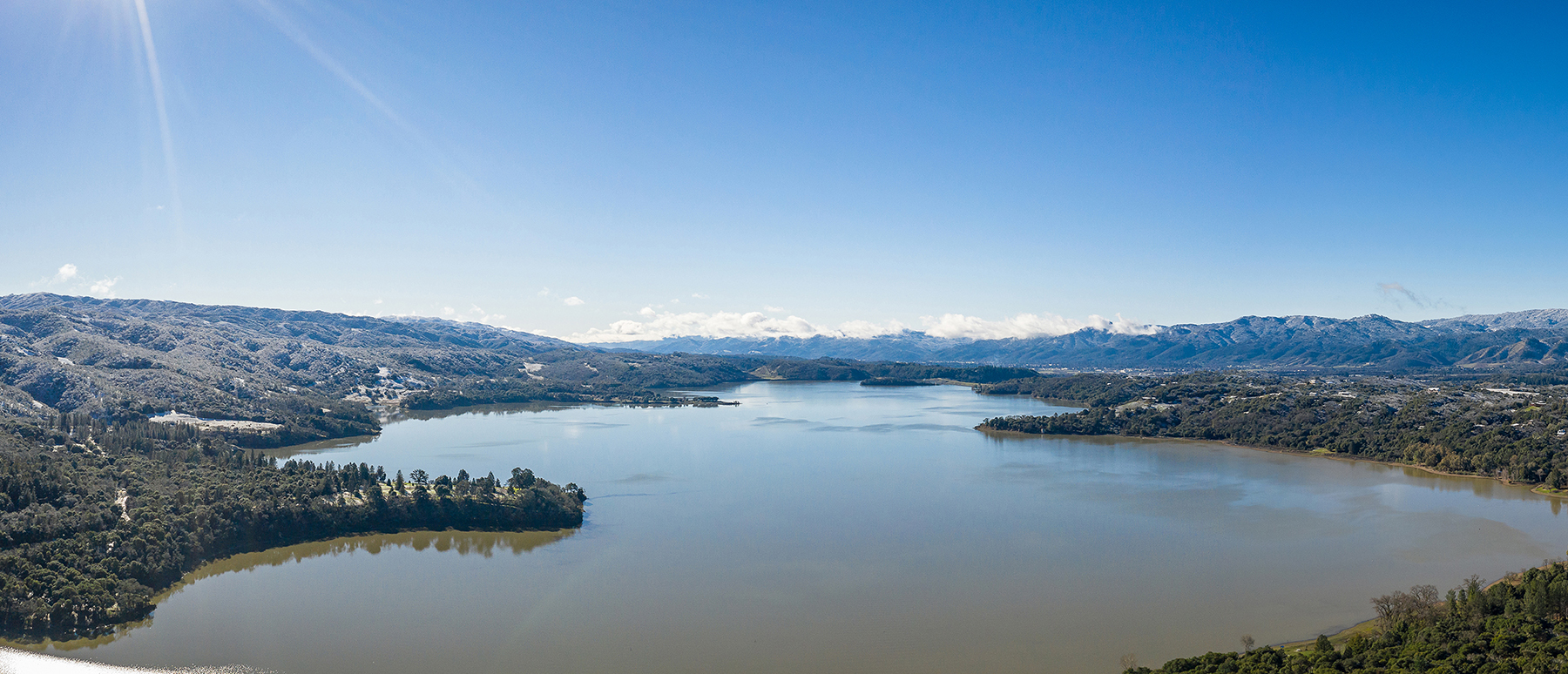
Located approximately 100 mi north of San Francisco on the East Fork of the Russian River in California’s Mendocino County, Lake Mendocino is owned and operated by the Corps, which oversees the flood-risk management aspects of the reservoir. Releases from the reservoir for the purposes of water supply or maintaining minimum flows to support fisheries and wildlife are managed by Sonoma Water, the local sponsor for the reservoir.
From October through December 2012, California received record levels of precipitation, says Michael Anderson, Ph.D., P.E., M.ASCE, the state climatologist for the California Department of Water Resources. But when the precipitation stopped, it did so for much longer than expected.
“New Year’s came around and the storms shut off,” Anderson says. “Then we launched into the driest 14-month period in our observed record.”
As the drought persisted, water that had been released from Lake Mendocino in December 2012 was sorely missed, Anderson says. “The question was asked, ‘Can’t we take advantage of (weather) forecasts to try and use that information in our reservoir operations to be more aware of what’s going on?’”
Atmospheric rivers and reservoirs
Before May 2016, water managers at reservoirs overseen by the Corps were not instructed to use weather forecasts as part of efforts to plan future reservoir operations. Instead, water managers were instructed to “operate to the principle of water on the ground,” meaning only measured levels of precipitation and snowpack could be used to guide management actions, says Cary Talbot, Ph.D., P.E., M.ASCE, the chief of the Flood and Storm Protection Division within the Coastal and Hydraulics Laboratory in the U.S. Army Engineer Research and Development Center.
However, the Corps modified its Water Control Management Engineer Regulation in May 2016 to explicitly allow the use of forecasted weather conditions for planning future operations at reservoirs.
Even before taking this action, the Corps had begun working with various partners to examine the viability of using forecasts of the meteorological phenomenon known as atmospheric rivers to guide reservoir management decisions. To date, these efforts have involved reservoirs in the western United States, where the presence or absence of atmospheric rivers tends to drive cycles of floods or droughts.
An atmospheric river is a “river in the sky, but it’s a river of water vapor instead of liquid,” says Marty Ralph, Ph.D., the director of the Center for Western Weather and Water Extremes at the Scripps Institution of Oceanography at the University of California, San Diego. The CW3E is a leader in the study and forecasting of atmospheric rivers.
In terms of their size, atmospheric rivers “tend to be about 10,000 ft deep, 500 mi. wide, and 1,000 or 2,000 mi. long on average,” Ralph says. “They are literally the largest freshwater rivers on earth, but rather than consisting of liquid like terrestrial rivers, they consist of atmospheric water vapor moved by wind.”
Upon making landfall, atmospheric rivers can drop massive quantities of precipitation. On average, atmospheric rivers produce about 30%-50% of precipitation in much of the western United States, Ralph says. “Here in the West, a few atmospheric rivers each year can make or break the water year in terms of water supply,” Ralph says. “If we don’t get enough of them, we can slide into drought. If we get too many, it can create floods. It really hinges on just a few storms each year.”
Although atmospheric rivers also affect the eastern United States, they are just one of a few different types of storms common to that region, so their overall influence on weather patterns and water cycles there is not as strong.
Forecasts of atmospheric rivers continue to improve, offering a key tool to those operating reservoirs. Compared with standard precipitation forecasts, “we have more accuracy in predicting an atmospheric river,” Ralph says. As a result, water managers relying on atmospheric river forecasts “can get more lead time” in terms of future weather conditions as compared with traditional precipitation forecasts, he says.
Assessing FIRO
Following a major drought in California from 2012 to 2015, Congress directed the Corps “to conduct research into whether or not forecasts specifically of atmospheric rivers could be improved to find a better balance between flood-risk management and water supply and ecosystem benefits,” Talbot says.
In response, the Corps partnered with such entities as the CW3E and the National Weather Service to assess the feasibility of employing the FIRO strategy at various reservoirs located in watersheds that are prone to experiencing the effects of atmospheric rivers. The findings have been extremely positive, Talbot says.
“On paper, it may seem like (the goals of) flood-risk management and water supply are in direct opposition to each other,” Talbot says. “But what we have found in this process is that’s not necessarily true.”
By relying on extremely accurate, reliable forecasts, water managers are better able to increase water availability in reservoirs during periods of good weather and release water in advance of storms that are likely to bring significant amounts of precipitation.
“You can actually improve not just water supply, but you can also improve the flood-risk management aspect of the reservoir as well by using the forecast to inform operators about what they might need to know going forward,” Talbot says.
‘Huge win’
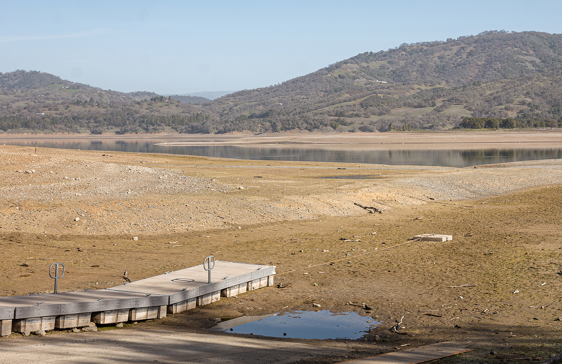
Once again, Lake Mendocino offers a case in point. The reservoir was the subject of the first pilot study of the FIRO process. Conducted by a multiagency steering committee, the study entailed a six-year process that culminated in the release in February 2021 of a final viability assessment of the use of FIRO at Lake Mendocino.
In California, the water year starts on Oct. 1. At Lake Mendocino, the water years 2019 and 2020 differed radically in terms of precipitation. “In 2019, we had a very wet year,” says Jay Jasperse, P.E., the chief engineer and director of groundwater management for Sonoma Water. By contrast, 2020 saw nearly 40% less than average rainfall. “We call it whiplash weather,” Jasperse says.
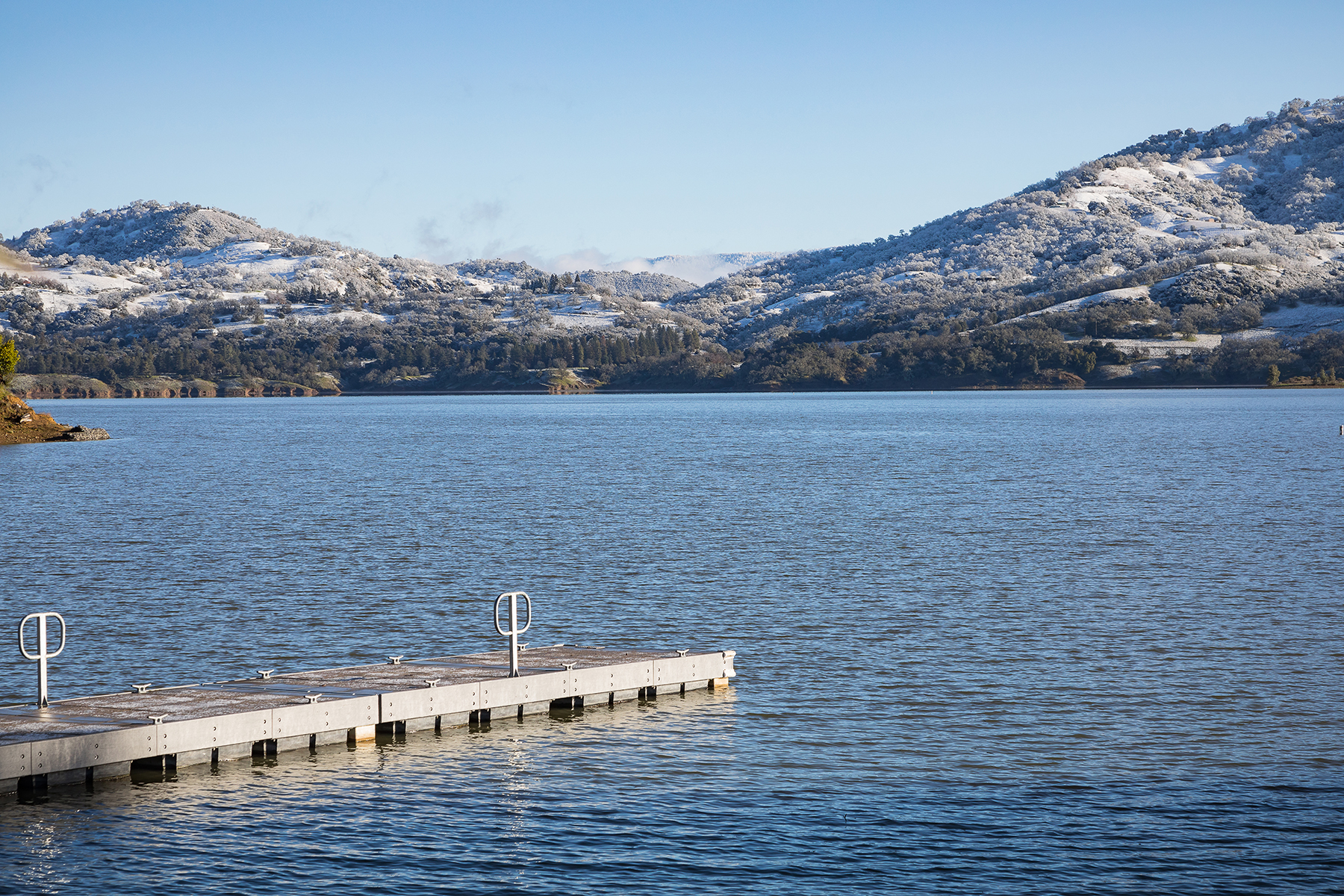
As it happened, the contrasting weather years afforded ideal circumstances for testing FIRO. During the 2019 water year, FIRO was used successfully to manage Lake Mendocino during periods of flooding, Jasperse says. However, the advantages of using FIRO became even more apparent the following year. In water year 2020, reservoir operators using FIRO were able to retain 19% more water in the reservoir than otherwise would have been allowed under the water control manual for Lake Mendocino.
“That’s a huge win right there,” Jasperse says. “I think it pretty much demonstrates the water supply benefits for FIRO.” At the same time, he notes, such water supply benefits also help improve conditions for fisheries and the environment along the Russian River.
Ongoing assessments
Besides Lake Mendocino, FIRO is being assessed at four other reservoirs. Currently, the Corps, the CW3E, and the Orange County Water District are studying its use at Prado Dam in Southern California as a means of improving the management of stormwater captured by the dam.
In Northern California, FIRO is undergoing an evaluation at two reservoirs located above flood-prone areas — the New Bullards Bar Reservoir on the Yuba River and Lake Oroville on the Feather River. Co-led by the CW3E, the Yuba Water Agency, and the California DWR, this assessment is examining FIRO jointly at the two reservoirs because their operations are coordinated to reduce flooding downstream on the Yuba River.
Most recently, the CW3E, the Corps, and Tacoma Public Utilities began planning the evaluation of the viability of using FIRO at the Howard A. Hanson Dam, a flood control structure on the Green River in King County, Washington.
These studies and the completed assessment of FIRO at Lake Mendocino represent “some really exciting developments in the combination of meteorology and hydrology,” Anderson says. Such developments are “fantastic examples of collaborative engagement” that enable civil engineers and others “to move forward as we increase our understanding of the world,” he notes.
Screening Corps reservoirs
The South Pacific Division of the Corps comprises the Sacramento, California; San Francisco; Los Angeles; and Albuquerque, New Mexico districts. Among the four districts, 74 dams are part of the initial screening test to determine if their reservoirs might make good candidates for FIRO, Talbot says.
Known as Stage A, the initial step of the assessment process entails a “high-level screening stage meant to identify and eliminate reservoirs at which FIRO would not currently be possible for a few basic reasons,” says Elissa Yeates, EIT, the acting chief of the Coastal Engineering Branch at the ERDC’s Coastal and Hydraulics Laboratory.
Such reasons, Yeates notes, could include a reservoir not having a controlled outlet or not having an existing water control plan, which is the section of a reservoir’s water control manual indicating the operational plan for meeting the congressionally designated purposes of a given reservoir.
“Contacts at those districts are evaluating their full portfolios of reservoirs by the shortlist of screening criteria,” Yeates says. In addition to reservoirs owned and operated by the Corps, the initial screening process includes reservoirs associated with so-called Section 7 dams. Although not owned or operated by the Corps, such dams received federal funds for flood control or navigation purposes. As a result, the Corps oversees the development of water control manuals for reservoirs formed by Section 7 dams.
Reservoirs that make it past the stage A screening will undergo further assessment to determine their suitability for the FIRO process. Known as stage B, this second step in the screening process will involve a “more detailed, intensive set of criteria and metrics,” including atmospheric forecast skill, hydraulic and hydrologic parameters, and stakeholder collaboration, Yeates says. Reservoirs then will be assigned a FIRO suitability ranking of high, medium, or low.
“Our plan is for each (South Pacific district) to select a subset of reservoirs that make it through (stage A of the screening process) for deeper consideration with the stage B tool this summer,” Yeates says. The exact criteria and metrics to be used as part of stage B are being developed now, she notes.
Reservoir sites receiving suitability rankings of high or medium then will enter stage C of the screening process. During this stage, which is to be completed sometime this fall, FIRO experts and site stakeholders will discuss the screening process outcomes and decide on next steps.
After testing the three-stage screening process in its South Pacific Division, the Corps intends to broaden its scope considerably, Talbot says. “The idea is that we would eventually take (the process) nationwide and use that on the entire Corps portfolio of dams,” he says.
However, more research remains to be done regarding atmospheric rivers and their effects on reservoirs, Ralph says. “To ensure the greatest potential for FIRO to be found viable at the most reservoirs, it is vital that focused research continue to improve forecasts of the extreme precipitation, the storms that produce them, the runoff they create, and the water resources management tools needed and that these advances make their ways into operations,” Ralph says.