By Assefa M. Melesse, Ph.D., P.E., BC.EE, BC.WRE, M.ASCE, and Alemayehu Gebriel, Ph.D., P.E., CFM, M.ASCE
The Grand Ethiopian Renaissance Dam represents the largest hydropower project in Africa and promises greater flood control and improved water management. But the project is not without controversy.
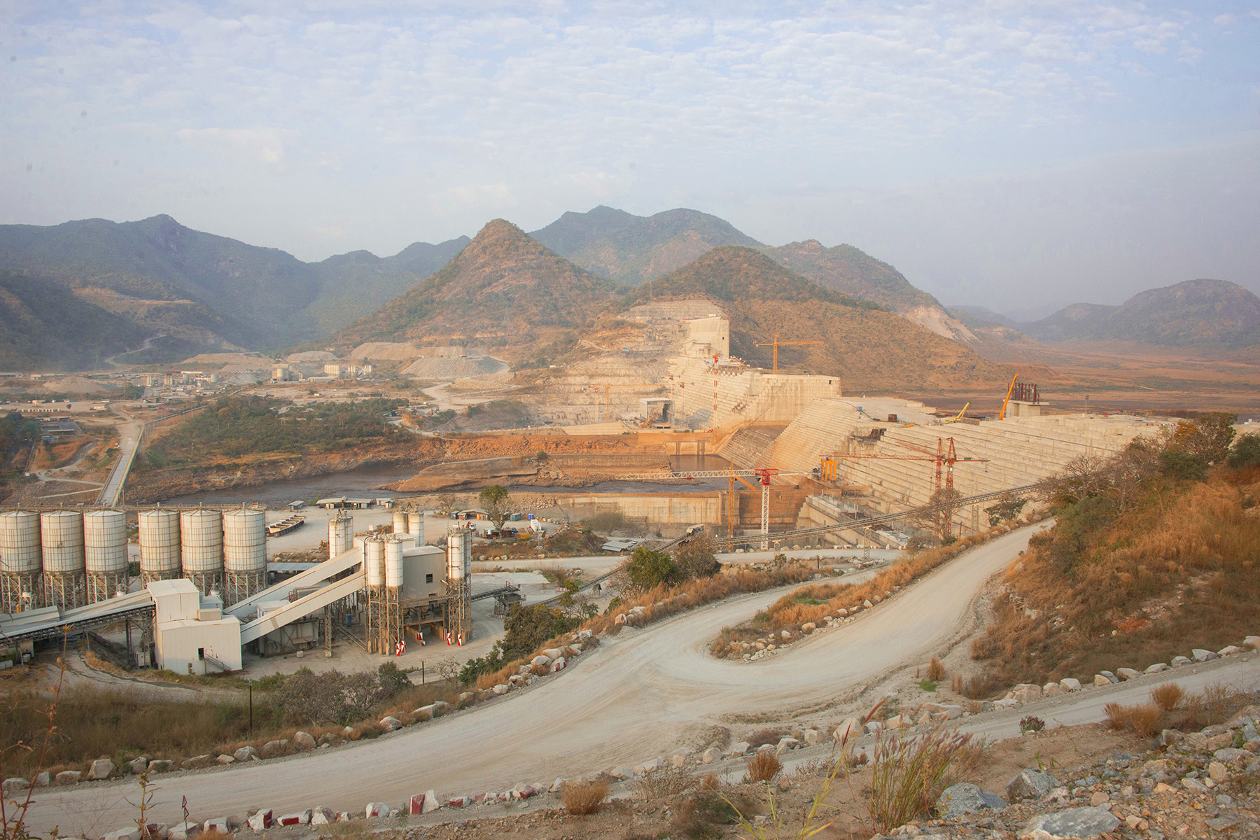
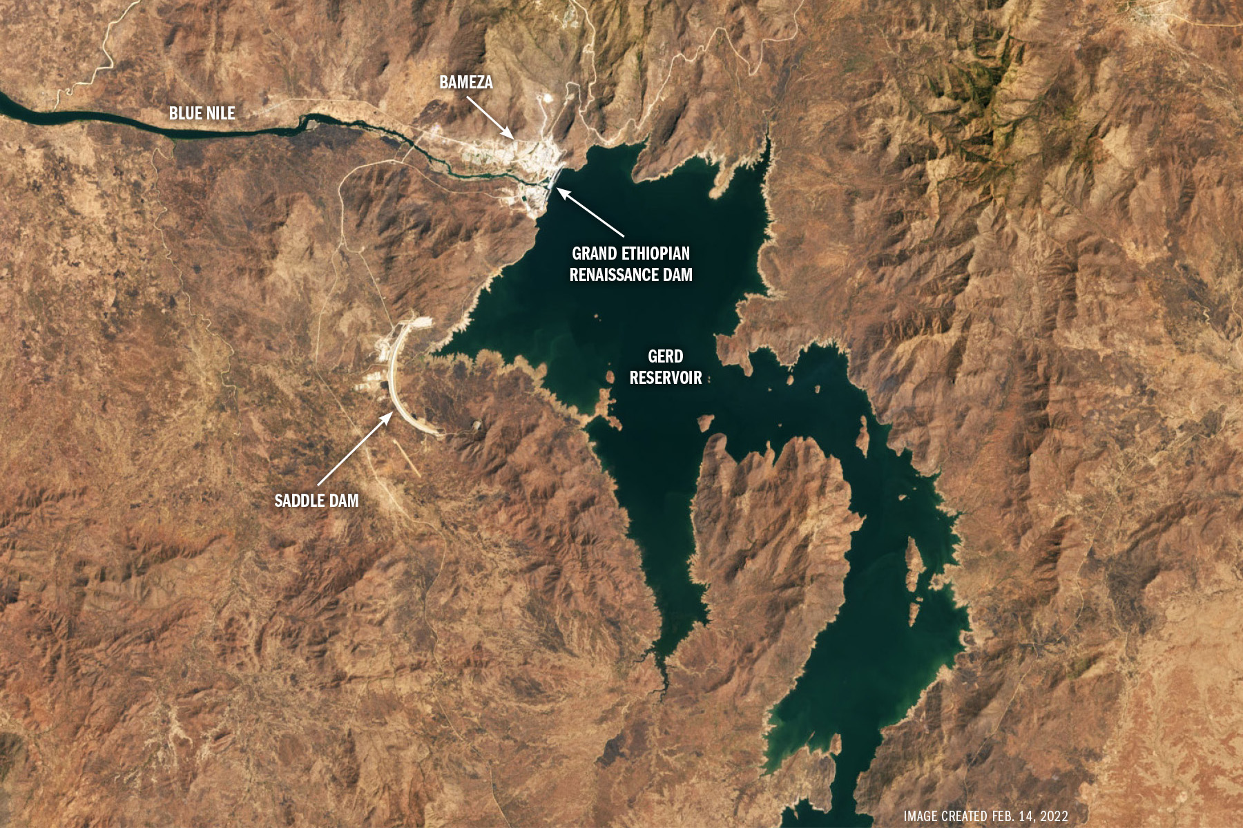
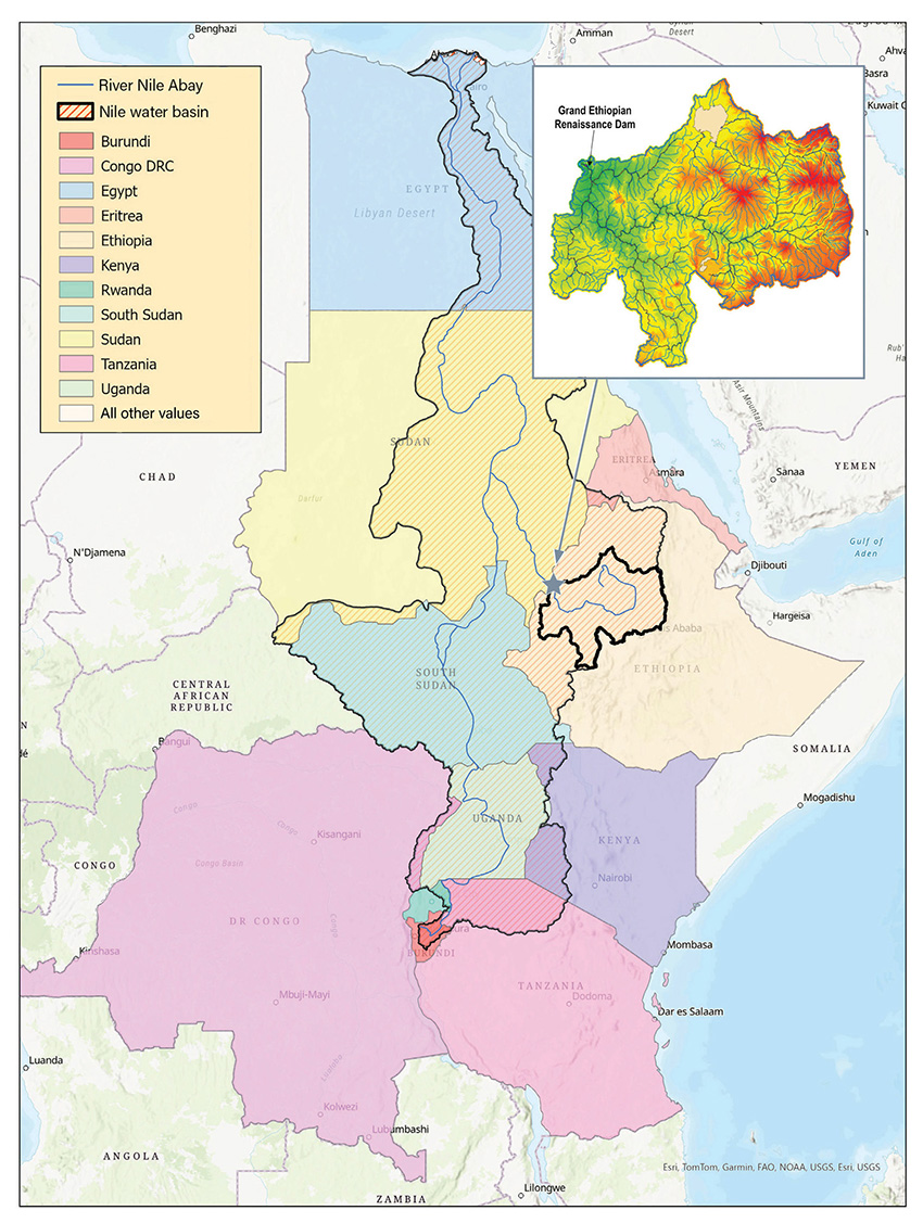
The Grand Ethiopian Renaissance Dam is located on the Blue Nile River, the larger of the two main tributaries of the Nile in East Africa. Known as the GERD, the dam was constructed in the Benishangul-Gumuz region of Ethiopia, approximately 20 km east of the Sudanese border. The main purpose of the GERD project is to meet the pressing need for reliable electricity for the growing population of Ethiopia as well as the region.
When the project broke ground in 2011, fewer than a third of Ethiopians had access to electricity, which severely hampered economic growth and quality of life (the authors of this article are originally from Ethiopia, where they were raised in homes without electricity). The dam promises to more than double the country’s electricity generation capacity, potentially transforming Ethiopia from an energy-deficient nation to a major power exporter in East Africa.
The Ethiopian government owns the project, with the state-owned Ethiopian Electric Power, an electricity producer, managing the dam. The $5 billion project was funded by the Ethiopian government, with the Ethiopian people contributing through the purchases of bonds and direct donations.
The GERD project had to overcome multiple challenges from design through construction, including geopolitical disputes. Despite these obstacles, the project is expected to be inaugurated by the end of this year, becoming the largest hydropower dam in Africa.
Power potential
The idea of harnessing the Blue Nile’s potential for hydropower generation has a long history in Ethiopia, but neither the technology nor the financial resources existed back then to realize such an ambitious project. The modern conception of the GERD can be traced back to a series of studies and negotiations spanning several decades. In the late 1950s and early 1960s, for instance, the United States Bureau of Reclamation conducted a comprehensive study of the region and recommended several cascading dams along the Blue Nile for hydropower production. But the lack of financing stopped the implementation of such projects. Still, one of the proposed locations, called the border dam, corresponds to the current site of the GERD.
Unfortunately, controversy over the GERD project has overshadowed historical aspirations for collaborative water management among Ethiopia, Egypt, and Sudan in the Eastern Nile Basin. One attempt at collaboration that did come to fruition is the Cooperative Framework Agreement, which establishes principles for equitable and sustainable water use among some of the other Nile Basin countries.
The framework agreement, which officially went into effect in October 2024, after years of negotiations, was developed by the Nile Basin Initiative, an intergovernmental partnership of Nile Basin countries. This historic development establishes a permanent Nile River Basin Commission to coordinate transboundary water management, but Egypt and Sudan did not sign the agreement.
While the GERD will function as a non-water-consumptive hydroelectric dam that temporarily stores and releases water during power generation, Egypt and Sudan are concerned that this megaproject may jeopardize their water security. Consequently, although Ethiopia, Egypt, and Sudan have considered various joint projects for the use of Nile water, these efforts all failed, leading the Ethiopian government to build the GERD on its own.
Multifunctional improvements
In addition to its primary function of power generation, the GERD serves multiple crucial purposes. As a flood control measure, it will help regulate the Blue Nile’s flow, mitigating devastating floods in downstream countries, particularly Sudan. (For more information on the river, see sidebar at the end of the article).
The dam’s improved water management capabilities are expected to increase agricultural productivity through irrigation, benefiting the region as well. Economically, the GERD presents a significant opportunity for Ethiopia to increase its foreign currency earnings by exporting excess power, thus driving overall economic growth.
Perhaps most importantly, from a national perspective, the GERD stands as a symbol of Ethiopian pride and self-reliance, demonstrating the country’s ability to undertake and finance large-scale infrastructure projects independently. This marked a significant shift from reliance on foreign aid to self-driven development.
The design and construction of the GERD was a collaborative effort among several international firms, each bringing its specialized expertise to this monumental project. Leading the way was a trio of Italian firms. Salini Impregilo (now known as Webuild S.p.A.) was the main contractor, overseeing the overall construction process. Studio Pietrangeli designed the dam and served as the owner’s representative. Geodata Engineering S.p.A. provided essential geological and geotechnical services, ensuring the dam’s foundation and structural integrity.
The electromechanical equipment was supplied and installed by Chongqing Iron and Steel Co. Ltd. GE Renewable Energy, now part of GE Vernova, supplied the turbines and generators.
Stats and specs
The GERD is a roller-compacted concrete dam, 145 m high and 1,780 m long. The main dam is complemented by an arch-shaped saddle dam 5 km long and 50 m high. When full, the GERD reservoir covers an area of approximately 1,874 sq km at an elevation of 640 m above mean sea level. It has a total storage volume of 74 billion cu m at full capacity.
The electrical generation system features two powerhouses on each side of the river channel. The powerhouses are equipped with a total of 13 turbines that have a combined installed capacity of 5,150 MW. The main dam is equipped with a gated main spillway and an additional ungated spillway, while the saddle dam provides an emergency spillway. Combined, these spillways safeguard the project against the probable maximum flood of 30,200 cu m/second.
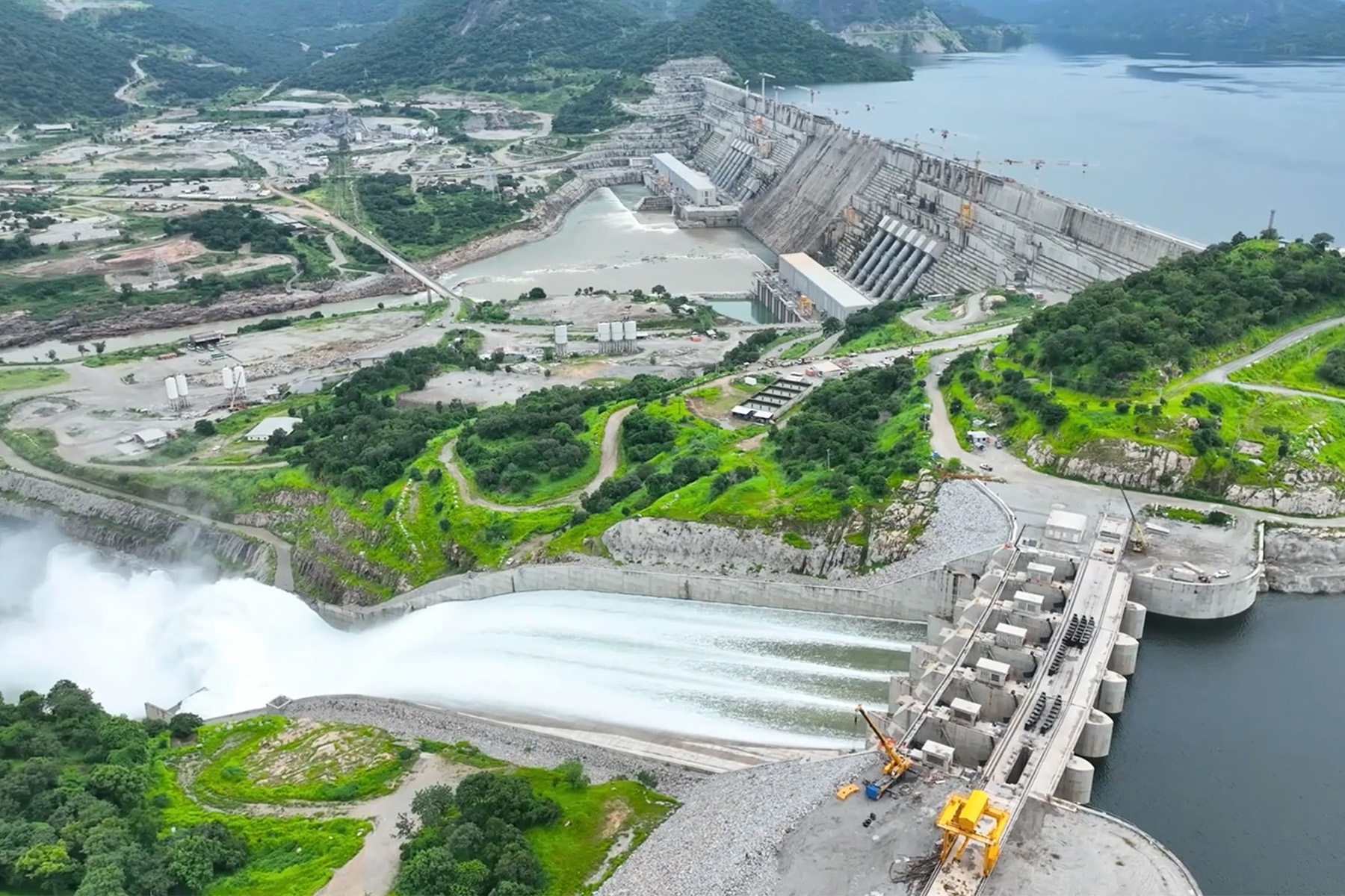
The gated spillway operates with six gates that can accommodate a design capacity of 14,500 cu m/second, while the ungated spillway can discharge 2,800 cu m/second. On the northeast side of the saddle dam, the emergency spillway is designed to accommodate a 1,000-year flood event. Energy dissipation for the emergency spillway is provided through a stepped chute on the downstream face of the gated spillway and the stilling basin at the bottom.
There are also two low-level-controlled outlets on the main dam with a potential release capacity of 830 cu m/second for the average annual flow of the Blue Nile. Four concrete diversion culverts were used to construct the dam’s foundation. These culverts were plugged after the river diversion was completed.
To control the uplift pressure at the dam foundation and to collect the water eventually seeping through the foundation and the dam body, an extensive drainage system has been installed, consisting of drainage galleries and foundation drains. The drainage system, composed of four longitudinal galleries at the upstream face of the main dam, is located at different elevations, including a bottom gallery at the downstream toe and several transversal galleries connecting the longitudinal gallery. The bottom gallery collects the water from the foundation drains and from the lower part of the upstream face drains.
The project was designed so that the filling of the reservoir would be an integral part of the overall construction endeavor.
The dam’s northeast and southwest sides were constructed first to an elevation of 645 m because they did not feature any steel components. During construction, the central block section of the dam, approximately 250 m wide, was initially lower than other parts of the dam. This was done to control the level of impoundment in the reservoir.
Milestones met
Work on the foundations began in 2011, and the river was diverted beginning in 2016. When construction of the central block reached 560 m in 2020, filling of the reservoir began and impounded slightly less than 4.9 billion cu m. The second filling, to approximately 10 billion cu m, was completed in July 2021 when the central block elevation reached 575 m. The third filling, of approximately 25 billion cu m, was completed in August 2022, with the central block reaching an elevation of 600 m. This enabled the first turbine to start generating power in 2022.
In 2023, the construction of the central block reached a height of 620 m, impounding approximately 42 billion cu m, which enabled a second turbine to become operational.
The three fillings from 2020 through 2023 occurred during very wet and above-average wet years in the river basin, so downstream flow reductions were nonexistent.
By July 2024, the concrete work neared completion, and two additional turbines were installed. At this stage, the water in the reservoir reached 636 m above mean sea level, while the river flow was high enough to require opening the gated spillway, discharging 2,800 cu m/second. In December 2024, the concrete work was finished, and the water level behind the dam reached its maximum height of 640 m. In April, seven turbines were operational, and the remaining six are in various stages of development.
Overcoming obstacles
Throughout its design and construction, the GERD faced a series of formidable challenges that could have halted the project. For example, the engineering design challenges required innovative solutions at every turn. The remote location of the dam site was the first major hurdle, necessitating the construction of extensive infrastructure, including access roads and a town for workers. This essentially involved building a small city in a remote area, complete with all the necessary amenities to support a large workforce over an extended period.
The enormous structure required careful engineering to ensure its stability, including the potential for seismic activity in the region (even though the GERD site is far from any major seismic zone). This necessitated advanced structural designs and materials capable of withstanding both the enormous water pressure and possible earthquakes.
Furthermore, initial geological studies revealed challenging foundation conditions, necessitating extensive excavation and foundation treatment to ensure long-term dam stability.
The region’s hot climate added another layer of complexity, particularly for concrete curing. To address this, the engineers employed innovative cooling systems and carefully planned construction schedules to ensure the integrity of the concrete structures.
Each of these challenges demanded cutting-edge engineering solutions, pushing the boundaries of dam construction technology and highlighting the project’s technical sophistication.
The dam was scheduled to be completed seven years after the cornerstone was placed in 2011. However, delays occurred due to design modifications and contractual issues with a local supplier.
A change of government in 2018 led to a restructured contractual arrangement and the replacement of a key supplier, which expedited construction.
The characteristics of the river presented additional obstacles, including a high sediment load that required accelerated implementation of basin-wide soil and water conservation practices. The significant variability in the Blue Nile’s flow between wet and dry seasons posed a major challenge, requiring a design that could effectively manage these fluctuations while maintaining consistent power generation year-round.
Security was also a concern at the construction site and on the roads that led to the GERD, which required armed guards to secure the supply route and the dam site. And finance remained a challenge even after several fundraising campaigns.
Promising future
As the GERD begins full operation, the development of a comprehensive reservoir operational plan is crucial. This plan must balance Ethiopia’s power generation needs and development with downstream environmental flows and water needs, along with future upstream water resource developments. Ongoing assessments of river ecosystems, locally and downstream, are essential for the sustainable management of water and environmental resources.
At the same time, the project offers an opportunity to shape the future of water resource management in the region. Despite the geopolitical disputes mentioned earlier, the success of the GERD could serve as a catalyst for greater cooperation in the Nile Basin, particularly in areas of power trading and water resource management. It might also promote greater economic integration in East Africa, potentially transforming regional dynamics.
The GERD represents a monumental engineering achievement and a transformative project for Ethiopia and the East Africa region, embodying the complex interplay between national development aspirations and regional resource management in the 21st century. While the GERD offers significant potential benefits in terms of power generation, flood control, and economic development, it also highlights the challenges of managing transboundary water resources in an era of climate change and increasing water scarcity.
Ultimately, the story of the GERD is not just about a dam; it is about the future of regional cooperation, sustainable development, and the delicate balance between human needs and environmental stewardship in one of the world’s most historic river basins.
Sidebar: The Blue Nile Hydrology and Significance
The Blue Nile Hydrology and Significance The Blue Nile begins at Ethiopia’s Lake Tana, where it is locally called the Abay River. It travels northwest approximately 1,450 km through Ethiopia and Sudan, cutting through deep gorges and shaping landscapes before joining the White Nile at Khartoum, Sudan. This meeting point marks where the combined waters begin their final journey to the Mediterranean Sea. The Blue Nile’s hydrology features distinctive seasonal flow patterns and delivers substantial contributions to the entire Nile system.
During the July-October monsoon season, the Blue Nile contributes roughly 53% (49 billion cu m) of the Nile’s total flow (91 billion cu m), demonstrating its hydrological importance. The river discharges approximately 1,548 cu m/second at its mouth, though this varies substantially between seasons. A key characteristic is its substantial sediment load, consisting primarily of fertile silt eroded from the Ethiopian Highlands. This nutrient-rich material has traditionally been essential for agriculture in Sudan and Egypt, depositing fertile soil along riverbanks and throughout the Nile Delta.
The Blue Nile’s hydrology encounters various challenges amid regional water management disputes. Climate change threatens to disrupt rainfall patterns and alter river flows. Meanwhile, dam construction has triggered extensive negotiations and water allocation concerns among Ethiopia, Sudan, and Egypt. These issues illustrate the complex balance between using the river’s hydropower and irrigation potential, preserving essential ecological functions, and ensuring fair water distribution among riparian nations.
As these challenges unfold, the Blue Nile’s hydrological future remains vitally important to millions who rely on its waters for their survival and livelihood.
Assefa M. Melesse, Ph.D., P.E., BC.EE, BC.WRE, M.ASCE, is a professor of water resources engineering in the Department of Earth and Environment at Florida International University. Alemayehu Gebriel, Ph.D., P.E., CFM, M.ASCE, is a water resources practice lead at Entech Civil Engineers in Houston.
Project credits
Owner
Government of Ethiopia
Main contractor
Webuild S.p.A., Rome
Dam design and engineering
Studio Pietrangeli, Rome
Geotechnical engineering
Geodata Engineering S.p.A., Turin, Italy
Electromechanical equipment
Chongqing Iron and Steel Co. Ltd, Chongqing, China
Turbines and generators
GE Renewable Energy (now part of GE Vernova), Cambridge, Massachusetts
This article first appeared in the July/August 2025 issue of Civil Engineering as “Powering East Africa.”

