By Jay Landers
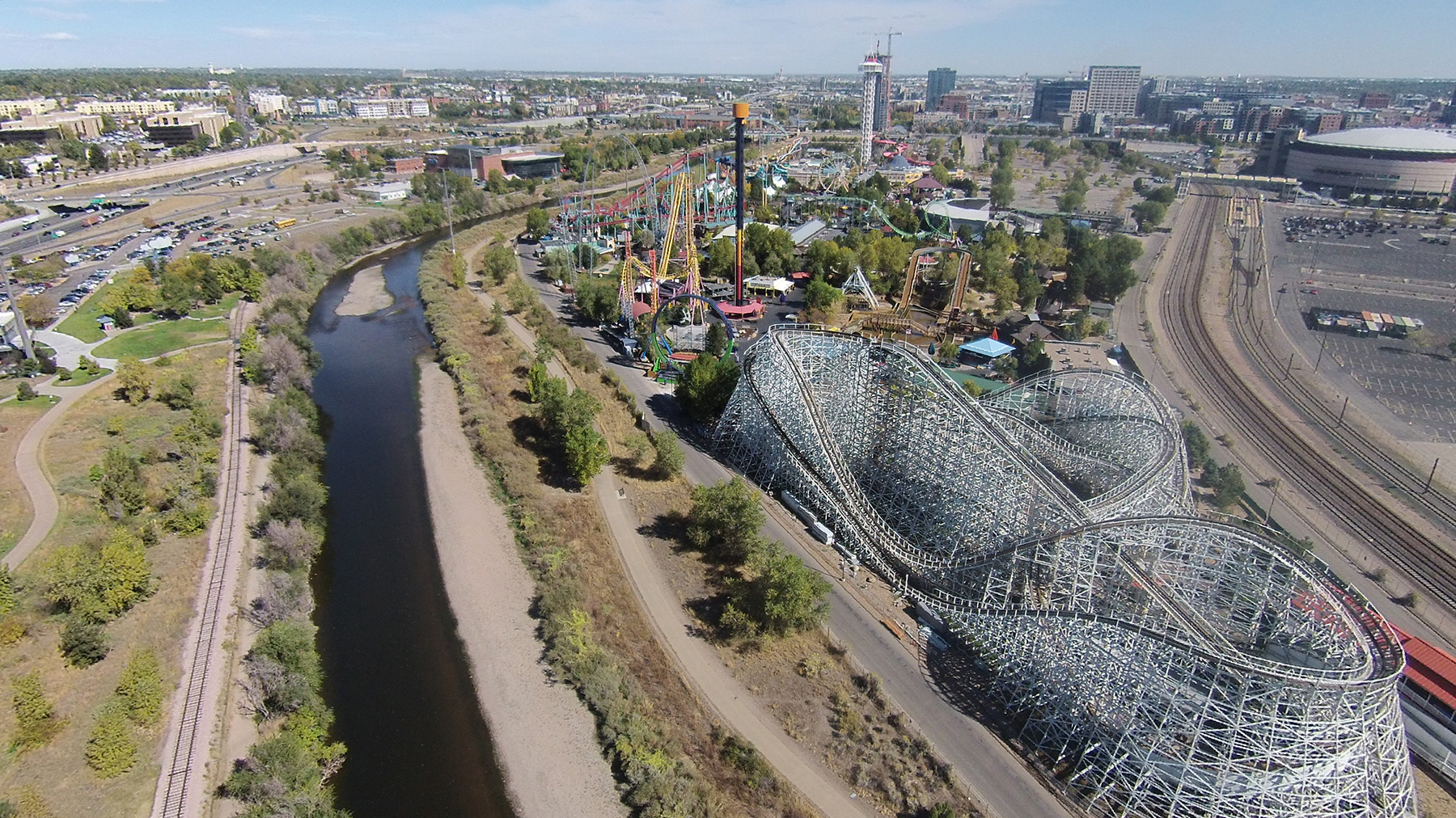
As it flows through the semiarid Denver metropolitan region, the South Platte River offers a range of critically important but increasingly rare — for the area — aquatic, wetlands, and riparian habitats. To improve and expand these habitats, the U.S. Army Corps of Engineers’ Omaha District and the city and county of Denver have ambitious plans to restore ecological conditions along a 6.5 mi long stretch of the river in Denver and Adams counties and reduce flood risks along two of its tributaries.
Known as the South Platte River & Tributaries Project, the estimated $550 million effort recently received a major boost, with the federal government allocating its entire share of the project costs at once, rather than going through the customary annual appropriations process.
Funding from the IIJA
The Corps released the Final Integrated Feasibility Report and Environmental Impact Statement, commonly known as the FEIS, for the South Platte River & Tributaries Project in April 2019. Congress authorized its construction in the Water Resources Development Act of 2020, which was included as part of the Consolidated Appropriations Act for fiscal year 2021 that became law (P.L. 116-260) in December 2020. All told, the South Platte project was authorized for a total cost of $550.3 million, of which the federal share is $344.1 million and the nonfederal share is $206.2 million.
On March 29, the White House released a fact sheet highlighting $2.7 billion of funding for some 300 Corps projects across the country, including the South Platte River & Tributaries Project. The funding was part of the $17 billion in supplemental appropriations provided to the Corps as part of the $1.2 trillion Infrastructure Investment and Jobs Act signed into law in November and now referred to as the bipartisan infrastructure law. The South Platte project received $350 million in upfront funding, according to the fact sheet.
The South Platte project “presents a unique opportunity for the Omaha District Corps of Engineers to partner with an extremely dedicated sponsor to restore a highly degraded river that would provide a significant boost in nationally significant habitat and habitat connectivity while also providing flood-risk reduction to hundreds of structures within both the Harvard and Weir gulch communities,” said Col. Mark Himes, the commander of the Omaha District, referencing the areas around the two South Platte tributaries that are key components of the project, in an April 1news release issued by the district.
‘Nationally significant ecosystems’
Given their location between the Rocky Mountains and the Great Plains, the South Platte River and its tributaries are “nationally significant ecosystems providing critical habitat linkages between” the river systems of the two regions, according to the FEIS. Meanwhile, the habitats also support migratory birds, particularly those traveling along the Central Flyway, the large swath of land encompassing much of the western United States that many bird species use while migrating north and south across the country.
Project components to be conducted along the South Platte River are intended to address, in part, the deleterious environmental effects resulting from three upstream dam and reservoir projects owned and operated by the Corps: the Chatfield Dam and Lake on the South Platte River; Cherry Creek Dam and Lake on Cherry Creek, a tributary of the South Platte; and Bear Creek Dam and Lake on Bear Creek, another tributary of the river. All three dams were constructed to reduce flood risks along the South Platte River.
Construction of the three upstream dams greatly altered the historical flow patterns of the South Platte River, according to Ashlee Grace, the director of the South Platte River & Tributaries Project for the city and county of Denver. “While providing important flood safety benefits, the dams have resulted in degraded habitats downstream along the South Platte River,” Grace says. “Additionally, urbanization and encroachment of the South Platte River have also led to degraded, low-quality habitat.” For example, banks along the river “suffer from a surfeit of invasive species,” Grace says.
Urbanization has destroyed or degraded much of the aquatic, riparian, and wetlands habitats in the Denver region. In fact, wetlands constitute only about 0.7% of the land area within the Denver metropolitan area today, according to the FEIS. Remaining aquatic habitats in the Denver area have been “severely degraded by altered flow and sediment regimes, channelization, additions of grade control drop structures, and other modifications,” the feasibility report notes.
Restoring, connecting habitats
The plan will restore approximately 160 acres of riparian corridor and wetland habitat and nearly 100 acres of aquatic habitat along the South Platte River, says Jennifer Williams, P.E., Denver’s FEIS lead. All told, vegetated wetlands will increase by 6.5% of the land mass within Denver’s boundaries. Another 190 acres of isolated habitat will be reconnected to the river corridor. These efforts will “strengthen the habitat connectivity through the corridor, directly benefiting the Central Flyway and migratory birds,” she says.
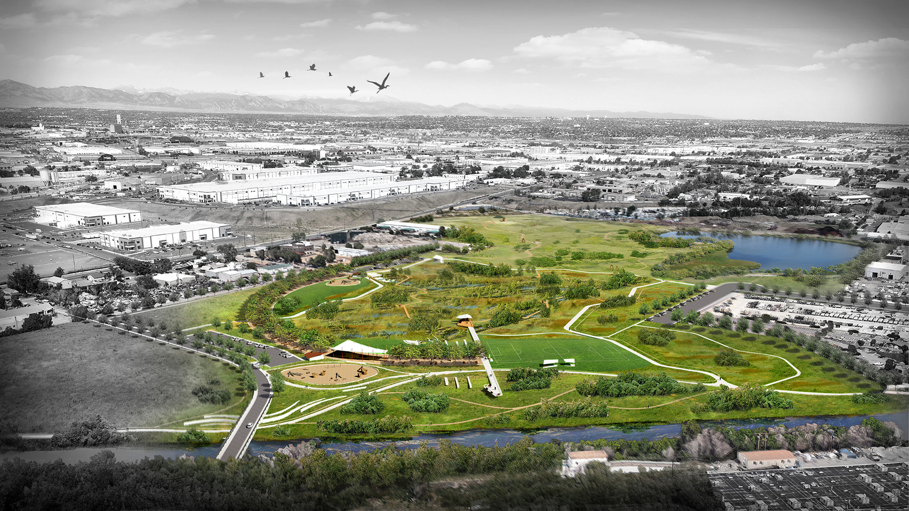
To attain goals pertaining to ecosystem restoration along the South Platte River, the project aims to “widen and flatten banks, where possible, to increase the riparian and wetland habitat,” Williams says. Where possible, banks will be regraded to improve their stability. To improve aquatic habitat, jetties and in-stream benching will be installed. Throughout the project, invasive species will be removed and replaced with native plantings, Williams says.
In certain locations, existing sewer lines and trolley tracks will be relocated to facilitate project improvements. At the same time, the project will provide flood-risk management benefits that will remove approximately 100 structures from the regulatory floodplain along the river.
Equity considerations also have informed the development of the project, Williams says. The project “provides ecosystem restoration and flood-risk reduction for diverse, culturally vibrant neighborhoods,” she notes. At the same time, the project “promotes environmental sustainability, including climate resiliency and potential stream temperature reductions, along an urban river corridor that has suffered from environmental injustices.”
Reducing flood risks
Weir Gulch and Harvard Gulch flow through significantly developed watersheds. The 3.5 mi long Weir Gulch drains a watershed of approximately 7.7 sq mi, while the roughly 3 mi long Harvard Gulch accepts flows from a highly urbanized watershed of nearly 8 sq mi.
In their existing conditions, the two tributaries are “currently undersized and (are) incapable of handling the 1% annual chance flood,” Williams says. “Urbanization, including construction of concrete-lined channels and subsurface conduits, have significantly reduced the amount, connectivity, and quality of riparian, wetland, and in-channel habitat along” the waterways, she says.
Meanwhile, flood risks are especially high along Harvard Gulch. “Under existing conditions, residences and businesses may be subject to flooding and potential structure damage during moderate to major events,” Williams says.
The project calls for the use of channel and culvert widening along Weir Gulch to reduce flood risks to life, safety, and property. Ultimately, the measures are expected to remove 360 structures from the 1% annual chance exceedance floodplain. All told, more than 850 people, approximately 60% of the population at risk, will be removed from the 0.2% annual chance exceedance floodplain along Weir Gulch, according to the FEIS.
On Harvard Gulch, voluntary, nonstructural measures will protect about 176 structures from flooding. Non-structural improvements may include elevating structures, filling basements, or dry floodproofing structures.
‘Alternative delivery options’
In its feasibility report, the Corps had estimated that the project might receive its first congressional appropriation in 2023. Construction was estimated to begin in 2024 and last 20 years.
However, receiving full federal funding upfront is expected to expedite the project schedule, says Bert Matya, P.E., the project manager in the Corps’ Omaha District. “The goal is to complete (the project) much earlier than what was laid out in the (final feasibility report),” Matya says. “Having full federal funding allows us to work with our client to look at alternative delivery options.”
For example, Denver has applied for the project to be accepted into the Corps’ public-private partnership pilot program, Matya says. “The application is being reviewed and analyzed for acceptance, but formal acceptance into the program has not been determined as of yet,” he says.
Begun in 2019, the P3 pilot program is intended to “streamline delivery, share risk, and provide significant life-cycle cost savings” on certain projects conducted by the Corps and local sponsors, according to the Corps’ website for the program. In 2021, the Fargo-Moorhead flood diversion project on the Red River at the border of North Dakota and Minnesota became the first civil works project involving the Corps to involve a P3 (see “P3 improves US Army Corps' Midwest flood-diversion project,” Civil Engineering, Aug. 26, 2021).
Denver is “in the early stages of planning for implementation with our project partners, both local and federal,” Grace says. “This includes working through various partnership and funding agreements between the city and county of Denver and the U.S. Army Corps of Engineers.”
Besides Denver, local support for the project is coming from such entities as the Mile High Flood District, the Greenway Foundation, and the state of Colorado, including the Colorado Water Conservation Board.