By Jay Landers
In the winter of 1861-62, California and other Western states experienced a series of strong storms that resulted in what came to be known as the Great Flood of 1862. In California, the Central Valley temporarily turned into an inland sea some 300 mi long, while in the southern reaches of the state the areas that today constitute Los Angeles and Orange County also saw significant flooding. In other words, regions that were inundated then have become critical components of the nation’s agricultural sector or highly urbanized areas inhabited by millions.
In the intervening 160 years, California has not had to endure flooding on a magnitude anywhere near that of the Great Flood. Were such an event to happen again, the consequences to life and property would be extraordinarily severe. Meanwhile, it is possible that an even larger flood event could occur. This possibility was explored recently by researchers looking to characterize what they call the “plausible worst-case scenario” versions of the extreme storm sequences that could befall California.
In a recent journal article, “Climate change is increasing the risk of a California megaflood,” the researchers conclude that climate change has increased the likelihood and intensity of such a megastorm occurring in the coming decades.
Flooding from such an event would be expected to significantly strain California’s existing flood-control systems, raising questions about what infrastructure owners can do to better prepare for future megafloods.
Doubled risk
Authored by Xingying Huang, Ph.D., an atmospheric scientist at the Climate and Global Dynamics Laboratory within the National Center for Atmospheric Research, and Daniel Swain, Ph.D., a climate scientist at the UCLA, who is also affiliated with the National Center for Atmospheric Research and The Nature Conservancy, the article appeared in the Aug. 12 issue of the journal Science Advances.
Based on climate model data and high-resolution weather modeling, the researchers determined that climate change has doubled the risk that conditions similar to those that caused the Great Flood of 1862 could occur again in California. Of even greater concern, they warn that future warming from climate change will increase the risk of such an event further.
Such events, the researchers say, will result from increases in the intensity of the meteorological phenomenon known as atmospheric rivers. These are the gigantic volumes of water vapor in the atmosphere that can produce massive amounts of rainfall when they encounter land.
For California and much of the American West, atmospheric rivers generate between one-third to one-half of the annual precipitation. Although often the source of major flooding, such events play a beneficial role by restoring water supplies in otherwise arid environments. However, atmospheric rivers are expected to confer increasingly negative effects as they grow in intensity and frequency.
Double whammy
Huang and Swain studied two hypothetical scenarios, both of which were drawn from a large ensemble of climate-model simulations for different periods: a scenario based on data collected from 1996 to 2005 in the first case and a much warmer future period projected for 2071-80 in the second. For both scenarios, they looked at the meteorological conditions and runoff that would be associated with recurring, extreme 30-day storm sequences.
In both cases, the “30-day cumulative precipitation is extremely high,” according to the article. In the historical scenario, “we find broad regions exceeding 500 mm of cumulative precipitation, with widespread areas exceeding” 1,000 mm or more in different mountain ranges, the article notes. In the future scenario, “spatial patterns of event total precipitation are similar but are uniformly characterized by heavier accumulations, with broad areas in both Northern and Southern California exceeding 700 mm and widespread areas” within mountain ranges receiving more than 1,400 mm, according to the article.
The problem is not simply the increased volume of precipitation that the extreme storms are expected to produce, Swain says. “You’re not just getting more water more quickly,” he says. “You’re also getting much warmer storms that are bringing this water.” Swain calls this result the “double-whammy effect.”
“You end up seeing runoff that increases by an even larger fraction than you’d expect from the precipitation increase, because especially in mountain areas, we’re seeing much more of this precipitation falling as liquid rain rather than snow,” Swain explains. “It runs off immediately into rivers and streams, generating and contributing to flood flows rather than accumulating slowly and melting gradually or gently weeks or months after the storm has passed as snowpack would typically do.”
Compounding matters further, hourly rainfall rates during individual storm events are expected to increase significantly. Such a change would have “high potential to increase the severity of geophysical hazards such as flash flooding and debris flows,” particularly when occurring near newly barren wildfire burn areas, the article notes.
Increasing the odds
The researchers conclude that the chances of a California megastorm not only have increased over time but will continue to increase in the future as warming continues. “We find that climate change has already doubled the likelihood of an event capable of producing catastrophic flooding, but larger future increases are likely due to continued warming,” according to the article.
For example, the researchers found that, by approximately 2060, the annual likelihood of a megastorm similar in nature to the historical scenario increases by roughly 374%. For an event formerly having a 200-year return interval, the annual likelihood increases by approximately 683%. “These statistics represent notably large increases in risk of California megastorm events due to climate change, as they transform an event that previously would have occurred once every two centuries into one that may occur approximately three times per century,” the article states.
With stronger megastorms more likely to occur in the future, existing infrastructure must be reevaluated to ensure that it can continue to perform as intended, Swain says. “A lot of the infrastructure that’s already in place may not be up to the task of the extreme events that are now increasingly plausible in the 21st-century climate.”
Implications for infrastructure
The study’s findings provide a “chance to do a lot of exploration” in terms of what might be needed to improve capabilities both in terms of infrastructure as well as emergency response, says Michael Anderson, Ph.D., P.E., M.ASCE, the state climatologist for the California Department of Water Resources, which helped fund the research by Huang and Swain.
The findings can be used as a measure to ensure that infrastructure funding is prioritized “to advance that resilience that moves that bar a little higher, so that we can accommodate the bigger storm and have the resilience to rebound more quickly after such a storm,” Anderson says.
Although concerning, the study’s results should be viewed in the proper perspective, says Marty Ralph, Ph.D., the director of the Center for Western Weather and Water Extremes at the Scripps Institution of Oceanography at the University of California, San Diego. The CW3E is a leader in the study and forecasting of atmospheric rivers.
The findings highlight the “most extreme of the most extreme possibility,” Ralph says. “There’s a rationale to do that. It's important for people to be aware, in my opinion, that such extremes are possible.” However, “the chances that things will be that severe, because of the nature of it being extreme, is a little uncertain,” he notes.
That said, the study’s results do require careful consideration, Ralph says. “One of the implications of this work, and of related earlier studies on atmospheric rivers, is that it would be useful to further evaluate the readiness of our flood control and water supply system for extremes, both flood and drought, in California’s future.”
As one of the major developers and owners of water-related infrastructure in California, the U.S. Army Corps of Engineers will evaluate the study’s results as part of the “larger body” of research regarding the potential effects of climate change on precipitation and runoff in the state, says Tim Fairbank, P.E., the chief of the Hydrology and Hydraulics Branch at the Corps’ Los Angeles District.
“We’re not super reactive to individual research studies or articles for making long-term decisions for life safety, property, and resources that are at risk,” Fairbank says. The recent study’s results “will definitely be considered and taken into account,” he says, “but we’re looking at a wide range of all of the studies that are involved in the topic when we make our future decisions.”
Along with doing its part to understand the low-probability, high-risk events that could affect its infrastructure, the Corps seeks to ensure that local emergency response personnel also are aware of the potential risks, says Aaron Smith, a senior project adviser at the Corps’ Dam Safety Modification Mandatory Center of Expertise. The Corps aims to “make sure (emergency responders) have the information necessary to prepare to keep their citizens safe in the event one of these large, more catastrophic, although infrequent, events could happen,” Smith says.
Upgrades underway
Some California water agencies have begun the process of upgrading their infrastructure to increase their resilience and improve safety in the face of future atmospheric rivers. For example, the Yuba Water Agency, which provides flood-risk reduction and water supply reliability for California’s Yuba County, plans to add a second spillway to its New Bullards Bar Dam.
Known as the Atmospheric River Control Spillway, the new $240 million feature will be located 31.5 ft lower than the dam’s existing spillway. Once in place, the new spillway will “help us manage an additional 117,000 acre-feet for flood-risk reduction,” says John James, the director of natural resource planning for Yuba Water, which also helped fund the research by Huang and Swain. The agency is working with GEI Consultants to develop the project’s design, which is scheduled for completion early next year.
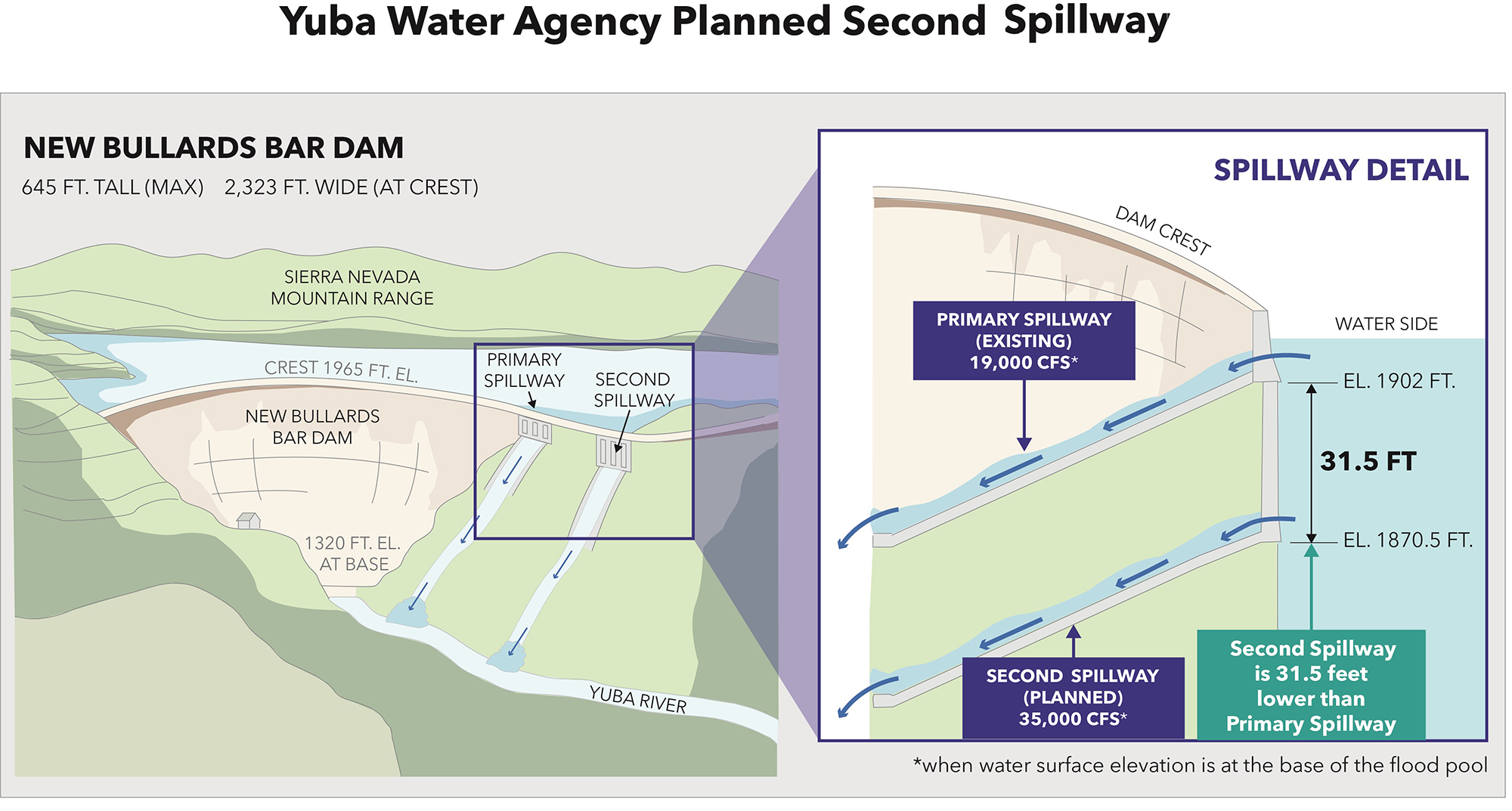
Although it will improve the ability of Yuba Water to reduce flood risk and increase climate resilience, the second spillway is not designed to accommodate the extreme flooding associated with the megastorms envisioned in the research of Huang and Swain. “The project that we’re designing anticipates that there’s going to be more frequent and larger storms,” James says. “But it’s not being designed to fully mitigate for the worst scenario in a future climate.”
Another approach that Yuba Water is evaluating as a means of attempting to manage the large runoff volumes from atmospheric rivers is a process known as forecast-informed reservoir operations. Relying on advancements in weather and hydrologic forecasting to improve reservoir management, FIRO enables operators to manage reservoirs more flexibly than is normally possible to optimize reservoir operations.
Yuba Water is working with the Corps to update the New Bullards Bar Reservoir water control manual, which outlines the operational rules for flood control for the reservoir formed by the New Bullards Bar Dam. To this end, Yuba Water aims to answer two key questions, James says. “How do we improve atmospheric river forecasting and how do we take those new forecasts and apply new rules that would be contained within the water control manual update to be more operationally flexible?”
Proactive, not reactive
As for the research project by Huang and Swain, their findings presented in the Science Advances article represents the “first phase of a three-tier project that’s intended to be deeply integrated with public policy and planning at the state and broader levels,” Swain says. The second phase of the effort will entail working with the DWR to conduct flood inundation modeling for the entire state of California, he says.
To achieve this goal, the DWR is in the process of developing a partnership with the Oak Ridge National Laboratory, the developer of the advanced hydrodynamic modeling tool known as the Two-dimensional Runoff Inundation Toolkit for Operational Needs, Anderson says. “We would further develop and tailor (TRITON) for the state of California, so that California has a statewide inundation modeling capability, which would be a really cool advancement.” Subsequent modeling efforts then might look at individual cities or larger regions, Anderson says.
The final phase of the three-tier effort, Swain says, will involve integrating the atmospheric data and inundation data with agencies responsible for planning efforts at the community level. In this way, communities would be able to adopt policies and implement infrastructure that will better prepare them for the more intense storms of the future. “Our hope is that doing this now, we have enough of a head start to move the needle on some of these issues while we can still be proactive rather than reactive,” he says.