By T.R. Witcher
The mighty Colorado River supplies potable water to approximately 40 million people in seven U.S. states plus parts of Mexico. The growth of cities such as Los Angeles and Las Vegas would be impossible without it. The same is true for the Phoenix and Tucson metro areas, which are home to roughly 85% of the population of Arizona.
Sunny skies and good weather (in non-summer months, at least) may have drawn millions to Arizona’s Sun Corridor, but it is water that has fueled the region’s stunning growth. That water comes from one of the most ambitious public works projects along the Colorado River, the massive $4 billion Central Arizona Project, described on the system’s website as “the most expensive Bureau of Reclamation project ever constructed, and perhaps the most controversial.”
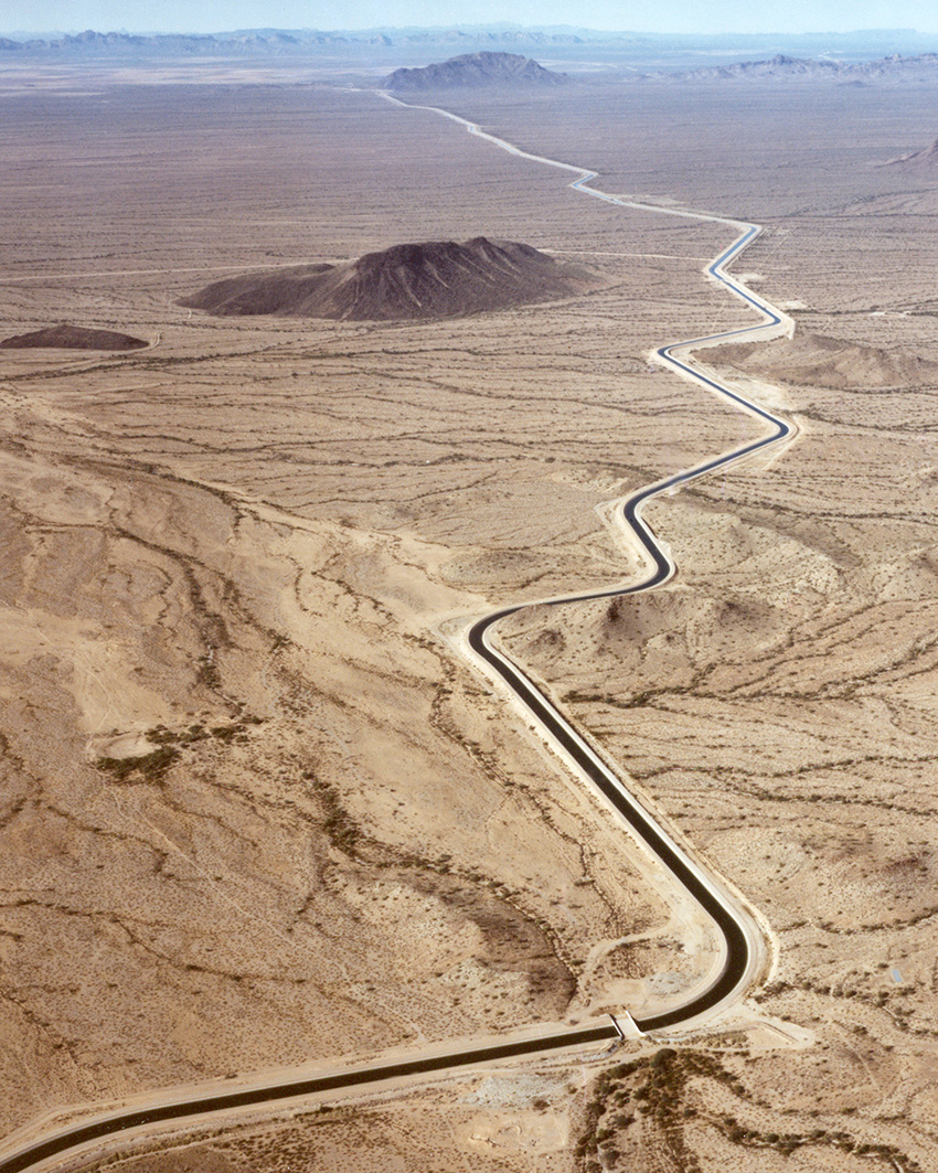
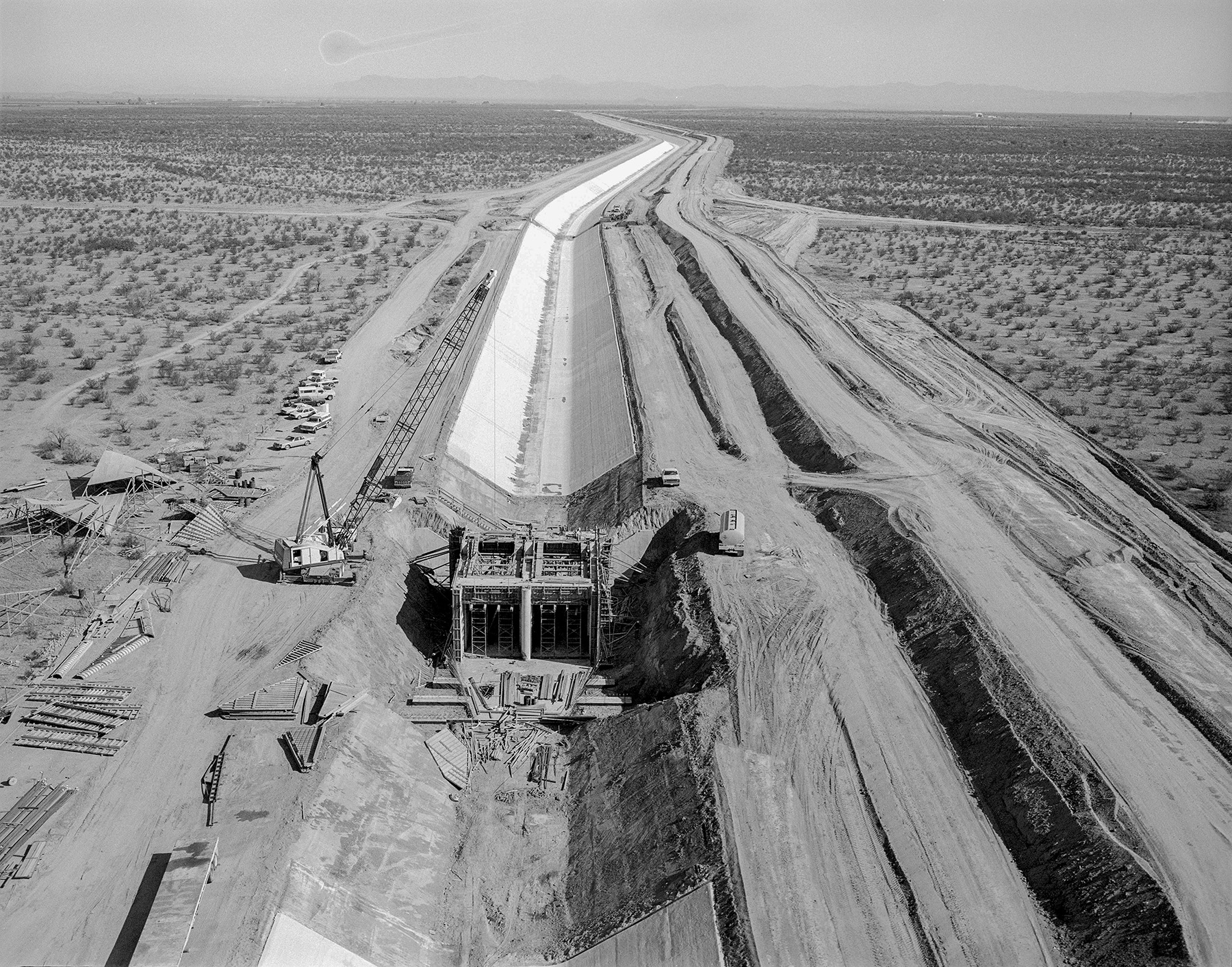
The CAP is a complex system of aqueducts, tunnels, pumping stations, underground siphons, and reservoirs that collectively move more than 1.4 million acre-ft each year roughly 336 mi across the Sonoran Desert. The CAP transports water from Lake Havasu to the west to points south and east, ending just south of Tucson.
The system brings water to approximately 1 million acres of land in the heart of Arizona and helped the state nearly double its population in the roughly 30 years since it was completed in 1993. The project has generated more than $2 trillion in economic value, providing “power generation, flood control, outdoor recreation, sediment control, and fish and wildlife conservation,” according to Jennifer E. Zuniga’s 2000 Bureau of Reclamation paper, The Central Arizona Project.
Americans did not invent the idea of irrigating the Sonoran Desert, which stretches across southern Arizona and into Mexico and where summer temperatures can approach 120 F. As far as back as A.D. 200, the ancient Hohokam people began developing irrigation systems on the Salt River — which would one day flow through the center of early Phoenix. Zuniga wrote that this early project comprised “complex systems of ditches dug with wooden sticks and stone axes. Simple bush dikes and diversion dams controlled water flows enough for the Hohokam to develop an irrigation empire.”
Ultimately these works would extend roughly 150 mi. But the Hohokam vanished around A.D. 1400 — no one knows for certain why, but scholars speculate drought and overcultivation of land.
Other Native peoples later lived in the region, including the Pima, Maricopa, and Tohono O’odham. American settlers entered the region in larger numbers after New Mexico Territory — which included most of modern Arizona — became part of the United States in 1848, drawing farmers, ranchers, and miners (copper mining in particular became a mainstay of the area’s economy). By the 1860s, according to Zuniga, “these settlers began redeveloping the land along the Salt River that the Hohokam once farmed. Sometimes farmers used the prehistoric canals, but usually they built their own following the paths of the ancient ones.”
Yet, despite advances in technology, 19th-century farmers encountered problems similar to those the Hohokam experienced. “Without large dams on the rivers to provide flood control and store water for later use during drought years, agricultural success still depended upon the whims of nature,” Zuniga wrote. “When the rivers swelled with runoff, meager diversion works failed, fields flooded and crops washed away.” By the time farmers rebuilt their waterworks, she wrote, “river flows usually dropped to a trickle and remaining crops withered and died in the desert heat.”
The river was anything but predictable. In 1891, a devastating flood tore through Phoenix, washing away homes, destroying a railroad bridge in Tempe, and wiping out irrigation canals, according to a history of the event (“‘A Terrible Calamity Has Fallen Upon Phoenix’: The 1891 Flood and Salt River Valley Reclamation,” Andrew M. Honker, The Journal of Arizona History, Vol. 43, No. 2, Summer 2002, pages 109-132).
In 1902, President Theodore Roosevelt signed a law that provided federal loans and technical expertise for reclamation projects in the Western U.S. Settlers banded together the following year to form the Salt River Valley Water Users Association and “pledged their land as collateral for a federal government loan to build a massive water storage and delivery system,” according to documentation on the website of the Salt River Project, an Arizona water and power utility.
The centerpiece of efforts to tame the Salt River was the Theodore Roosevelt Dam, begun in 1905 and completed in 1911 (and named an ASCE National Historic Civil Engineering Landmark in 1970). The dam, Zuniga wrote, “marked the beginning of the development of ... central Arizona from an inhospitable desert into an agricultural oasis.” Agricultural production in the valley “bloomed as the new water works provided a steady water supply and protection against all but the worst natural disasters.”
According to the Bureau of Reclamation, the Salt River system would become “almost totally controlled” by more dam construction from 1911 through the mid-1940s. Still, farmers depended on groundwater, and during the same time period, as the population grew and better pumps allowed more water to be extracted from the ground, groundwater levels began to decline.
In 1922, water officials representing the seven Colorado River Basin states signed the Colorado River Compact to govern the use of the Colorado River among them. The compact divided the resources of the river into Upper and Lower basins with 7.5 million acre-ft allocated to the Upper Basin states (Colorado, New Mexico, Utah, and Wyoming) and the same amount allocated to the Lower Basin states (Arizona, California, and Nevada).
Among the Lower Basin states, California received the lion’s share of water — 4.4 million acre-ft — while Arizona’s portion was 2.8 million. Though Arizona’s representatives initially agreed to the compact, the state’s legislature balked, and when the compact was ratified by the U.S. Congress in 1928, it was over the objections of Arizona. The state argued that the apportionments favored growth in California at the expense of Arizona. It was the beginning of a long-running feud over water resources between the states.

In 1934, when California began building Parker Dam on the Colorado River — more than 150 mi downstream from the then-under-construction Hoover Dam in Nevada and part of a plan to build an aqueduct to feed Southern California — Arizona Gov. Benjamin Moeur declared martial law and dispatched an infantry regiment to monitor construction. According to a National Park Service website, Arizona’s 158th Infantry Regiment commandeered a ferryboat to inspect the dam site. According to the website, “punsters made light of the Arizona Army that had become the ‘Arizona Navy.’”
Arizona eventually signed the river compact in 1944, but long before then promoters in the state had been developing their own ideas about how to leverage the Colorado River. One concept, put forth by George Maxwell, a longtime lobbyist for Arizona and California and water reclamation advocate, was dubbed the Arizona High Line Canal. It would, Zuniga wrote, irrigate about 2.5 million acres of farmland by diverting water from the “storage reservoir in the Boulder Canyon-Black Canyon area” (the site of Hoover Dam and Lake Mead) via a network of tunnels and aqueducts. But a preliminary geological survey deemed the project unfeasible. Another plan, suggested by Arizona state Rep. Fred T. Colter, “called for the construction of a reservoir above Lee’s Ferry with a storage capacity of sixteen million acre feet,” Zuniga wrote.
While the ancient Hohokam canal system and the early 20th-century Salt River Project were local efforts within the Salt River Basin, Maxwell’s plan was the conceptual foundation of the CAP — a project that would import water to the Salt River Basin from the Colorado River. By 1947, the Bureau of Reclamation had submitted a report on the feasibility of the project to the secretary of the interior. Ironically, a route emanating from Parker Dam that Arizona officials had objected to was deemed the most practical. According to Zuniga, the 1947 plan called for 1.2 million acre-ft to be “imported into central Arizona and used on existing agricultural lands.”
But legal disputes between Arizona and California held up the project for another two decades. A key issue was whether Arizona’s appropriation of 2.8 million acre-ft of water included the flow of the Gila River. Arizona maintained that the Gila flowed entirely within the state and therefore did not count as part of its allotment of the Colorado River Compact. California, on the other hand, argued that since the Gila was a tributary of the Colorado River, its flow should be considered part of Arizona’s entitlement.
In a 1963 opinion (Arizona v. California), the U.S. Supreme Court sided with Arizona, and in 1964 it issued a decree that Arizona and the other “lower basin states have a right to appropriate and use tributary flows before the tributary co-mingles with the Colorado River,” according to a Bureau of Reclamation website.
That decision paved the way for the CAP to finally get underway. After decades of wrangling, President Lyndon B. Johnson signed the Colorado River Basin Project Act in 1968, which authorized the Bureau of Reclamation to build the CAP. In 1971, Arizona established the Central Arizona Water Conservation District to manage the infrastructure (and oversee repayment to the federal government), and in 1973 construction finally began.
The spine of the CAP consists of three aqueducts. The first and longest is the 190 mi Hayden-Rhodes Aqueduct, which carries water from Lake Havasu, formed by Parker Dam, through metropolitan Phoenix. According to a Bureau of Reclamation website, Hayden-Rhodes consists of nearly 174 mi of concrete-lined open channel, seven major inverted siphons, three tunnels totaling 8.2 mi, and three pumping plants.
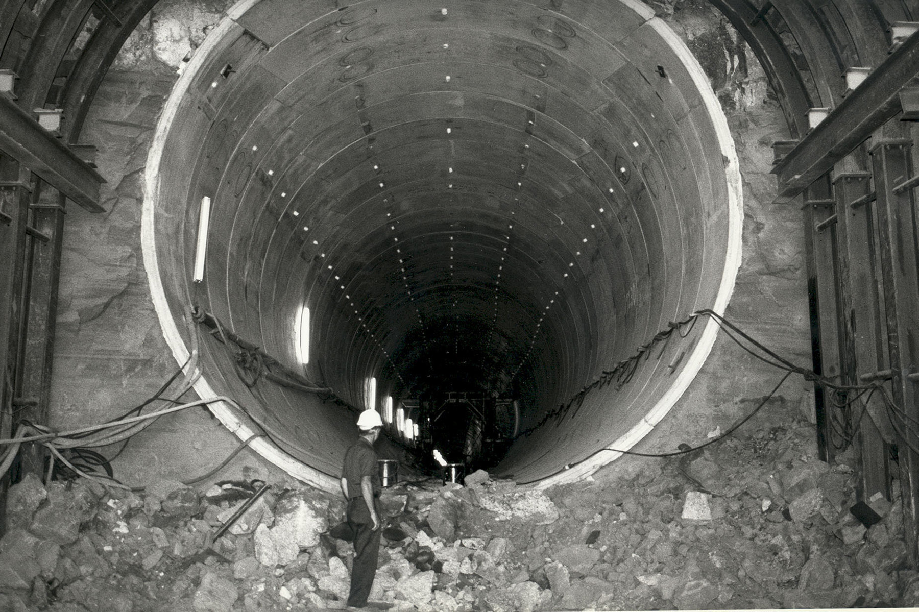
Hayden-Rhodes also features the largest elevation increase in the system. According to the Bureau of Reclamation, the system’s greatest lift is right out of Lake Havasu, where the Mark Wilmer Pumping Plant (the first in the system) lifts water 824 ft, thanks to six 66,000 hp pumps. The water is conveyed into the 7 mi long Buckskin Mountain Tunnel before flowing into an open canal. Hayden-Rhodes was completed in 1985.
According to a video produced by the CAP, it took engineers three years to bore through the Buckskin Mountain, just east of the Colorado River, to create a 22 ft diameter tunnel lined with precast concrete segments each weighing 3.5 tons. The tunnel is capable of conveying 3,000 cu ft of water per second.
The second main waterway in the system, the 57.5 mi Fannin-McFarland Aqueduct, which carries water southeast of Phoenix, was begun in 1981 and completed in 1987.The final waterway, the 87 mi Tucson Aqueduct, continues south from the end of the Fannin-McFarland Aqueduct and terminates south of Tucson. Construction of this final leg began in 1984 and was completed in 1993.
But, Zuniga wrote, “Within weeks of transition from groundwater to CAP water, residents in older parts of the city complained that the water was foul colored, had a poor taste and smell, and was corrosive to household appliances.” Tucson soon passed a regulation prohibiting the direct use of CAP water by residents; instead, Colorado River water was delivered to a series of recharge basins that stored the water underground and combined it with existing groundwater for the city’s drinking supply.
About 46% of the CAP’s total water supply is allocated to Native American tribes in Arizona.
Other key projects have contributed to the success of the water system. In 1985, construction began on the New Waddell Dam just outside Phoenix. The 5,000 ft long dam provides flood protection and irrigation water for the Maricopa Water District. A project to expand the original Roosevelt Dam was completed in 1996, increasing its storage capacity by 20%. The new structure, Zuniga wrote, was a “single-curvature, uniform thickness mass concrete arch dam covering the original stone masonry of the dam.”
The CAP aqueducts were designed with wildlife in mind. Ramps in the distribution canals allow animals to escape if they fall into them. According to Zuniga, fences were designed so that smaller animals like rodents and reptiles could slip underneath to drink water from the aqueducts.
In all, according to the CAP website, the system relies on 14 pumps, 39 radial gate structures to control water flow, and 50 turnouts to deliver water. As planned, the CAP delivers more than 1.4 million acre-ft of water per year and is the biggest power user in Arizona, at roughly 2.5 million MWh per year.
For the last 20 years, the Colorado River has been in a state of drought. In August 2021, as the water level at Lake Mead dropped below 1,075 ft, the federal government declared the first-ever Tier 1 shortage on the river. For Arizona, this means a reduction of 512,000 acre-ft, about 18% of the state’s annual apportionment, according to the Bureau of Reclamation. The bulk of the shortage will be borne by agricultural users, though water officials say that federal drought mitigation plans in place since 2019 have kept additional water in Lake Mead and Lake Powell, the Colorado River’s two main reservoirs.
As far back as the mid-1990s, the CAP began work on a series of water recharge sites at which water is stored in underground aquifers. According to the CAP, there are six recharge projects that collectively have stored about 300,000 acre-ft of water per year — essentially equal to the allotment for the state of Nevada. Still, continuing to conserve water will test a new generation of policymakers and engineers, just as bringing water across the vast and barren Sonoran Desert challenged their predecessors.
T.R. Witcher is a contributing editor to Civil Engineering.
This article first appeared in the March/April 2022 issue of Civil Engineering as “A Canal Runs through It: The Central Arizona Project.”