By Kristin Carlson, AICP, Kimberly Jaskot, and Vladimir Kanevskiy, P.E.
The $2 billion Mid-Coast Trolley light rail extension of the UC San Diego Blue Line is the culmination of meticulous design and planning, collaborative stakeholder participation, and extensive community outreach. The extension improves commuter options, reduces vehicular traffic, and gives commuters and residents alike better access to an area of San Diego that has a plethora of educational, employment, and housing opportunities.
San Diego has experienced rapid population growth in the last several years, and nowhere in the city has that been more apparent than in the popular neighborhoods around the University of California San Diego.
One of the main concerns to emerge from this population explosion — not to mention the anticipation of continued growth in the next 10 years — is the effect it will have on traffic and congestion, particularly along the city’s Interstate 5 corridor. For the last 40 years, San Diego has supported a successful light rail system that alleviates some vehicular traffic concerns, but its service did not reach this region.
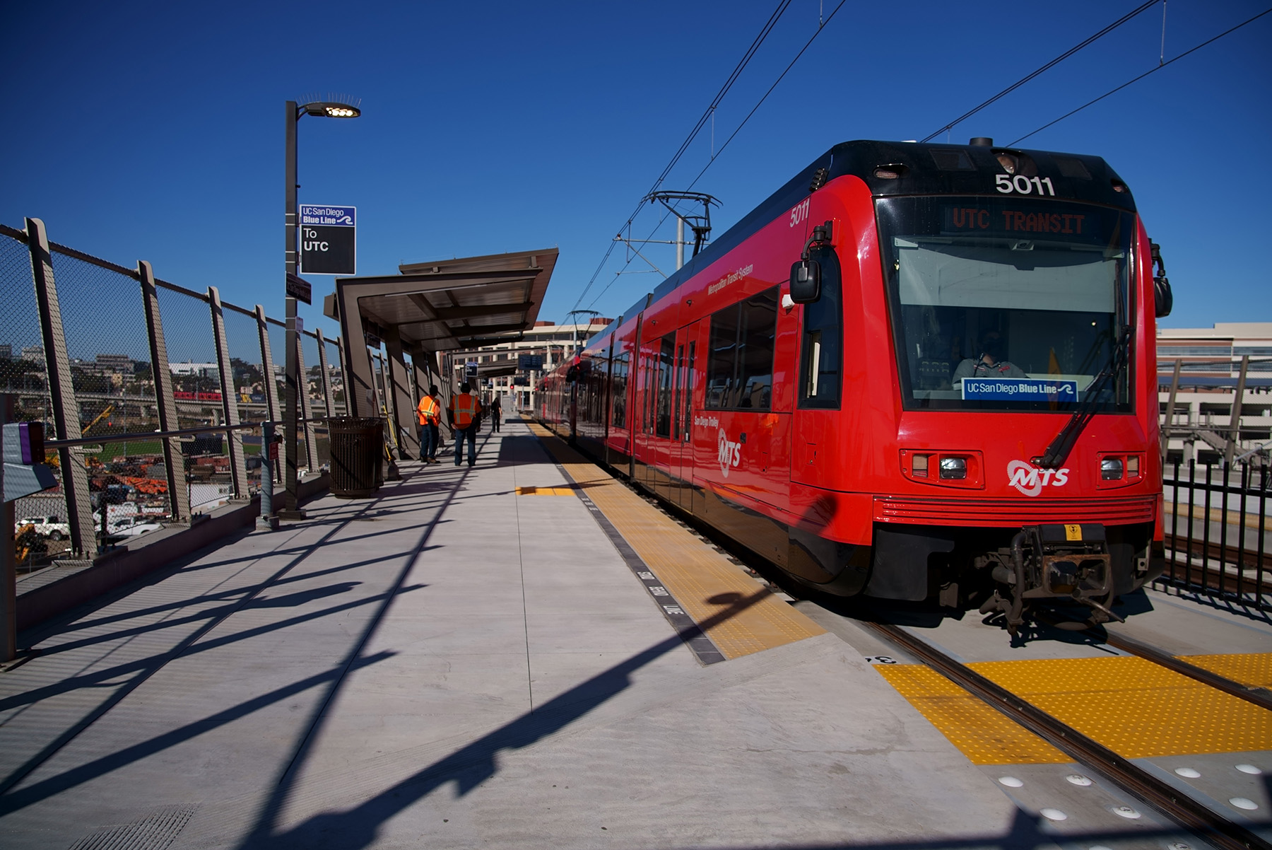
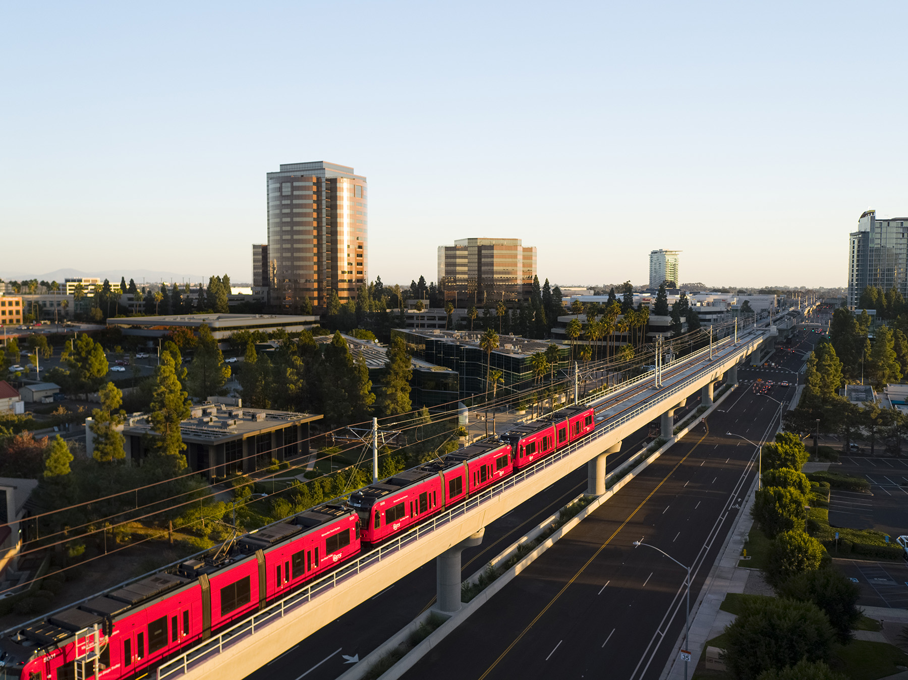
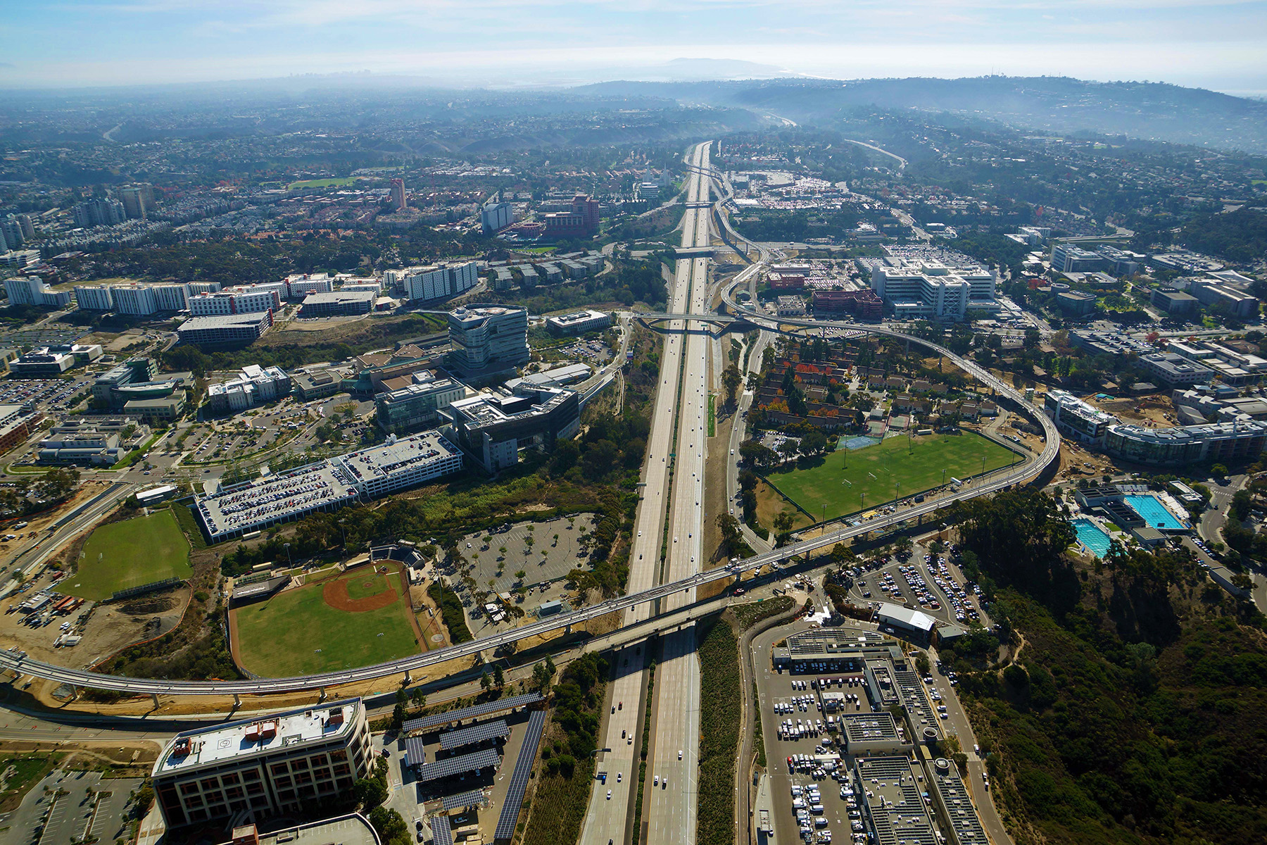
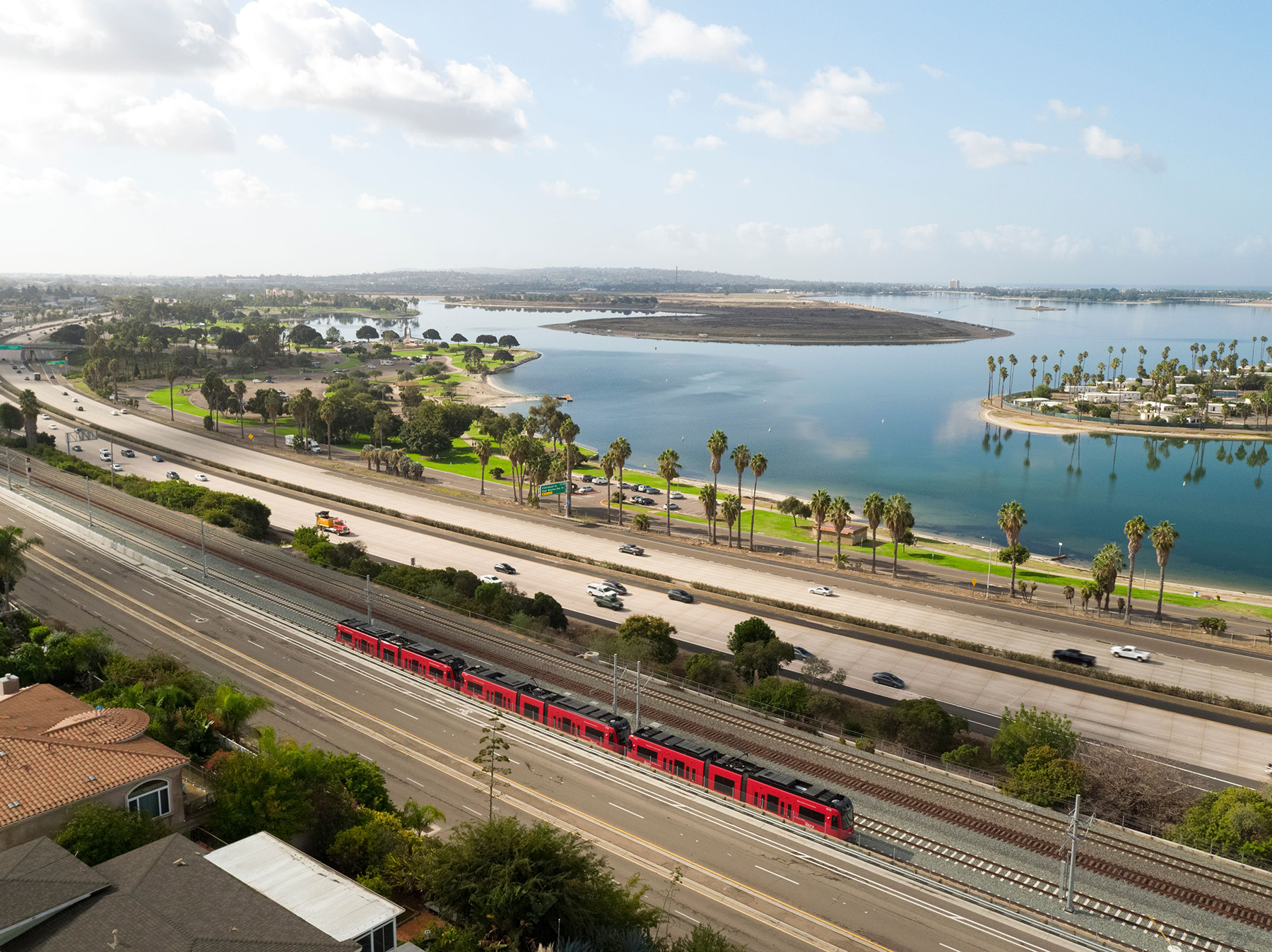
That all changed in November, when the 10.9 mi, $2.1 billion Mid-Coast Trolley double-track light rail transit extension of the UC San Diego Blue Line opened for public operations. The extension not only provides an effective alternative to congested roadways, but it also improves access to an area that is experiencing growth in employment opportunities, educational and medical facilities, and residential neighborhoods in addition to serving major activity centers, including UC San Diego, Mission Bay, and Westfield University Towne Centre.
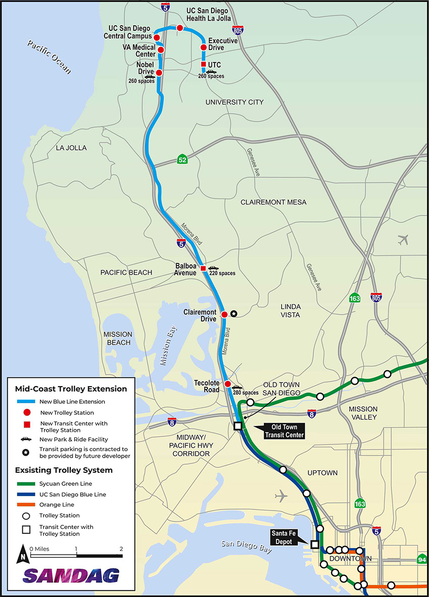
The LRT extension connects to other Trolley lines serving Old Town San Diego, Mission Valley, East County, downtown San Diego, and South County. The extension offers a transfer-free ride from the United States-Mexico border (at the southernmost station on the existing Blue Line) and communities south of downtown San Diego all the way to the University Community area. The new double tracks begin just north of the Old Town Transit Center and travel north along the railroad right of way that is adjacent to I-5 up to Gilman Drive. The tracks then head east, terminating at the UTC Transit Center, offering nine new stations along the route.
The San Diego Association of Governments was the client for planning, environmental clearance, design, and construction, while the San Diego Metropolitan Transit System is the operator. Other notable stakeholders were UC San Diego (two stations), the California Department of Transportation, the U.S. Department of Veterans Affairs (one station), and the city of San Diego. Coordination of project design and construction was also required with the North County Transit District to accommodate its future double track along a segment of the corridor and to minimize construction impacts to services using its tracks.
WSP has been involved in the project since the first contract was executed in 2008, serving as SANDAG’s lead environmental and engineering consultant and the designer of record. WSP handled multiple responsibilities for the project: planning, preliminary, and final engineering; New Starts (a federal grant program) funding advisory services; and design and environmental services during construction of the LRT extension.
Easing the burden
The UC San Diego Blue Line was the first in the city’s Trolley system, opening in July 1981. Prior to the extension, the Blue Line was 15.8 mi long with 18 stations, connecting the border with Mexico to downtown San Diego.
Of the nearly 11 mi of new track added to the Blue Line, nearly 7 mi is in a shared railroad right of way that is part of the 351 mi long Los Angeles-San Diego-San Luis Obispo Rail Corridor, which is the second-busiest passenger rail corridor in the nation. The LOSSAN Corridor is used by Amtrak’s Pacific Surfliner intercity service, COASTER commuter rail service, and BNSF Railway. The alignment is also within existing public rights of way owned by Caltrans, UC San Diego, and the city of San Diego.
As a result of being situated in public rights of way, property acquisitions mandated for the extension project were largely limited to only a portion of a property along the alignment, referred to as a partial acquisition. Larger acquisitions were related to station footprints, resulting in a total of six full property acquisitions. Only one business — a nursery — needed to be relocated to accommodate the project.
Some reconstruction and widening of Genesee Avenue were required to accommodate the aerial alignment, but overall impacts to the existing infrastructure were minimal. Multiple major utility relocations were also warranted, including high-voltage electric and natural gas transmission lines as well as a U.S. Navy aviation fuel line. Advanced construction methods, such as horizontal directional drilling, were necessary to accomplish these relocations.
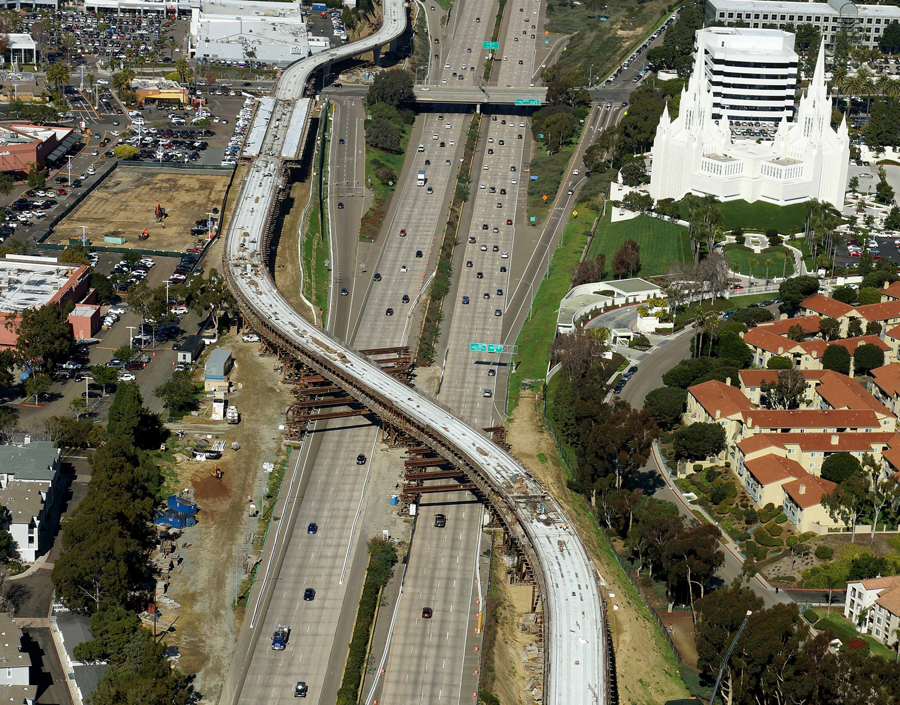
The project encompassed the design and construction of 11 bridge crossings and 4 mi of aerial viaduct structures, including a 1 mi long, two-track viaduct along Genesee Avenue. Four at-grade stations and five aerial stations were built, with five of those stations providing a total of 1,170 new parking spaces.
The LRT extension crosses the San Diego River, so to prepare the site for construction, ground improvements, such as jet grouting and rigid inclusions, were made to accommodate the deep foundations of the columns. Also, lightweight cellular concrete fills were implemented north of the river to mitigate the presence of highly compressible soils. This was done to prevent settlement of the existing structures and utilities adjacent to the LRT alignment.
Portions of the alignment are within or adjacent to Caltrans’ right of way. As a result, soil remediation and special considerations for exporting soil contaminated by hazardous materials were essential.
Limitation drives innovation
As an arterial street, Genesee Avenue is critical for providing vehicle access to the UC San Diego campus, residential neighborhoods, hospitals, a shopping mall, schools, and businesses. As such, one of the design requirements was to keep major intersections along this street operational throughout construction.
Full closure of the intersections was permitted only for short periods, and even then, only one intersection at a time. This requirement applied to six locations where precast girder spans crossed over live traffic.
The original design called for cast-in-place construction, but the design team opted to employ an alternative approach: splicing the precast girders on-site. The spliced girders, which varied in length from 140 ft to 192 ft, were erected and placed on temporary shoring towers during evening closures, lessening impacts on the traveling public, the surrounding community, and adjacent land uses.
The resulting viaduct constructed within the median of Genesee Avenue is the first curved spliced precast U-girder LRT bridge in Southern California. The techniques used to construct this viaduct will influence future designs in similar circumstances. The use of precast post-tensioned spliced girders is being considered on other WSP projects in which potentially significant traffic disruptions during construction need to be minimized.
Crossing a fault line
The design team developed detailed staging plans that involved temporary track shooflies, major gas transmission line relocation, multiple relocations of the Rose Canyon Bicycle Path, reconstruction of the Rose Creek flood-control channel, and construction of specialized retaining walls and a Rose Canyon LRT flyover structure adjacent to and over the LOSSAN mainline track. All this activity had to be done while maintaining 48 trains per day along this narrow rail corridor.
The project also had to account for design modifications to railroads, freeways, streets, and bike lanes at several locations to accommodate the LRT guideway.
This work necessitated a complicated progression of construction phases to accommodate numerous utility relocations, major street arterial widening, active railroad track realignments, and an ever-expanding UC San Diego campus. These factors caused many challenges that were thoroughly analyzed during the design development process, coordinated with affected stakeholders, and refined in tandem with SANDAG and the Mid-Coast Transit Constructors construction manager/general contractor team — a joint venture of Stacy and Witbeck, Herzog, and Skanska — during the preconstruction phase. This synchronization continued throughout construction.
In addition to a portion of the extension crossing the San Diego River, it also crosses the Rose Canyon Fault.
To ensure the long-term safety of the extension, the design team performed large-scale subsurface and geotechnical investigations, including: physical borings, cone penetration tests, and ground-penetrating radar scanning to accurately locate and assess multiple active tributary fault lines. Additionally, a special abutment design allows movement in the guideway superstructure to prevent the girders from unseating during seismic events.
Geotechnical observations conducted during the construction phase positively confirmed fault line locations, which helped the team avoid design changes later in the process caused by differing site conditions. As a result, the project team was able to maintain construction progress without interruptions.
Focus on environmental justice
An environmental justice analysis was conducted as part of the environmental clearance process to ensure fair treatment of those potentially affected by the extension. The analysis identified nine environmental justice communities within the Mid-Coast Corridor, five of which are within a half-mile of the alignment. What’s more, six of the nine new stations are in these communities.
The analysis concluded that there would not be any disproportionately high or adverse consequences to these communities and that more than 60% of user benefits would accrue to low-income groups both inside and outside the corridor.
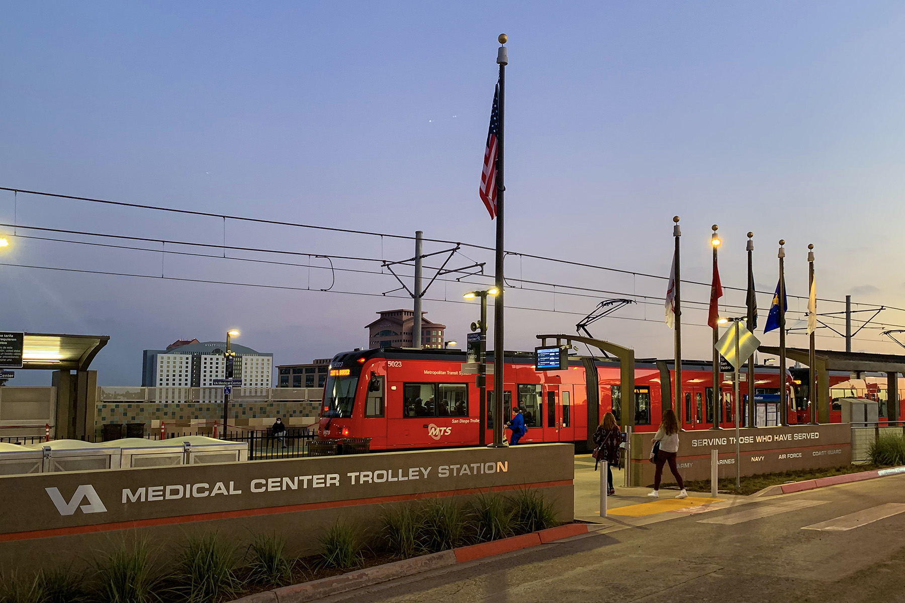
Furthermore, the Veterans Administration Medical Center Trolley Station provides convenient access for veterans — disabled and otherwise — seeking medical treatment.
Several disadvantaged business enterprises lent their support throughout multiple stages of the project. Their input proved to be invaluable in keeping the project on the right course.
Protecting a habitat
During the permitting process, the environmental team coordinated with the U.S. Fish and Wildlife Service, California Regional Water Quality Control Board, California Department of Fish and Wildlife, U.S. Army Corps of Engineers, and California Coastal Commission to modify the design of project elements to lessen environmental impacts on wetlands, sensitive vegetation types, and protected species. The sequencing of construction for the channel, bike path, and LOSSAN and LRT tracks was also an important consideration in the environmental analysis.
One of WSP’s responsibilities was to prepare the project’s National Environmental Policy Act and California Environmental Quality Act documents, plus the supplemental environmental impact statement and subsequent environmental impact report. WSP also oversaw and prepared the technical reports that supported the SEIS/SEIR.
Even though the project is situated almost entirely in public and existing railroad rights of way, the project team still faced environmental obstacles, such as the unexpected discovery of the federally endangered San Diego fairy shrimp within the railroad right of way.
As a result of the discovery, the team needed an alternative. A focused environmental document between the draft and final SEIS/SEIR was circulated to notify the public of the environmental impacts to the species and mitigation steps. Dudek, an environmental planning firm, developed the documentation with oversight from WSP.
The project team determined that attempting to avoid the fairy shrimp habitat by shifting the proposed LRT alignments would not only be costly and involve extensive realignment of the existing heavy rail tracks, but it would still indirectly affect the habitat. In the end, the USFWS agreed to develop a suitable off-site habitat for the species.
However, this species was later found to live in other areas along the railroad right of way within or adjacent to project features, which called for additional coordination with the USFWS and California Coastal Commission to address the situation during permit amendments and compliance.
Also of environmental concern was noise level — during construction and the subsequent running of the trains — due to the alignment’s proximity to residences and the UC San Diego campus. Mid-Coast Transit Constructors developed a plan to minimize noise created by construction activities that included limitations on nighttime construction. To reduce the reverberations of train operations, the project team installed sound walls at two locations of the alignment.
WSP also devised an electromagnetic interference plan to protect sensitive equipment at the UC San Diego campus and medical facility. The design team chose a split-power configuration system. Parallel feeder cables below the tracks are connected to the overhead catenary system wires intermittently with cable risers at the OCS poles. By positioning the feeder cables and return current as close together as possible, magnetic fields were reduced.
The firm also continues to provide support for compliance with the mitigation monitoring and reporting program.
Decades in the making
Funding for the project was part of Proposition A, which incorporated a local half-cent transportation sales tax known as TransNet that is administered by SANDAG. Proposition A was approved by voters in 1987 to support transportation projects in the San Diego region. Three years later, the environmental review process for the extension project began.
There have been variations in the alignment since that time; however, it was always the plan to have a connection between downtown San Diego and the University Community.
WSP provided grant procurement services, which were vital for SANDAG securing a $1 billion Federal Transit Administration Full Funding Grant Agreement. The federal funding matched approximately $1 billion provided by TransNet. Construction began in 2016 once the project was fully funded.
The project was completed via a CM/GC delivery method. Significant work began with an advanced utility relocation contract supplement about a year in advance of proceeding with construction of the rest of the project. The Mid-Coast Transit Constructors CM/GC team was brought on board at the 60% design phase to provide preconstruction services, along with constructability reviews and coordination with stakeholders.
TYLin International, in partnership with HDR, provided program management services, and Jacobs and PGH Wong provided construction management services.
This project presented many technical challenges, including difficult geological conditions, utility conflicts, adjacency to an active railroad, and construction in an urbanized environment in which the impact to businesses, schools, and medical facilities had to be carefully studied and controlled.
SANDAG conducted extensive community outreach, which contributed to positive public perceptions about the project. That support was essential to achieving major milestones throughout the environmental clearance process and, ultimately, the delivery of one of the largest and most important infrastructure projects ever undertaken in the region — on time and on budget.
The project has been substantially completed and is in the closeout phase with only minor work remaining, such as revegetation along the new alignment.
Kristin Carlson, AICP, is a project manager for environmental support. She can be reached at [email protected] and on her LinkedIn profile at linkedin.com/in/kristin-carlson-86160017a. Kimberly Jaskot is a principal technical specialist, senior lead consultant-civil engineer. She can be reached at [email protected] and on her LinkedIn profile at linkedin.com/in/kimberly-jaskot-8a32571b. Vladimir Kanevskiy, P.E., is an engineering manager. He can be reached at [email protected] or on his LinkedIn profile at linkedin.com/in/vladimir-kanevskiy-b22741227. All three are based in WSP’s San Diego office.
Project credits
Owner/Client: San Diego Association of Governments
Operator: San Diego Metropolitan Transit System
Designer of record/Lead environmental and engineering consultant: WSP, San Diego
Construction manager/general contractor: Mid-Coast Transit Constructors, a joint venture of Stacy and Witbeck Inc.,
Alameda, California; Herzog Contracting Corp., St. Joseph, Missouri; and Skanska, San Diego office
Program management: TYLin International, San Diego office; HDR, San Diego office
Construction management: Jacobs, San Diego office; PGH Wong, San Diego office
This article first appeared in the July/August 2022 issue of Civil Engineering as “Extending Access.”