By Jay Landers
California’s Central Valley could not have become one of the world’s most productive areas of farmland without its significant groundwater supplies. Until the development of the major state and federal water projects that began delivering surface water to the area in the second half of the 20th century, the Central Valley relied almost exclusively on groundwater.
Heavy pumping of groundwater has led to significant land subsidence throughout the valley, causing major damage in some areas to canals, aqueducts, and other infrastructure.
This subsidence was particularly pronounced in the valley’s southern half, which is known as the San Joaquin Valley. By 1970, approximately half the San Joaquin Valley, or roughly 5,200 sq mi, had subsided by at least 1 ft, according to the website of the U.S. Geological Survey. Some locations had subsided by as much as 28 ft.
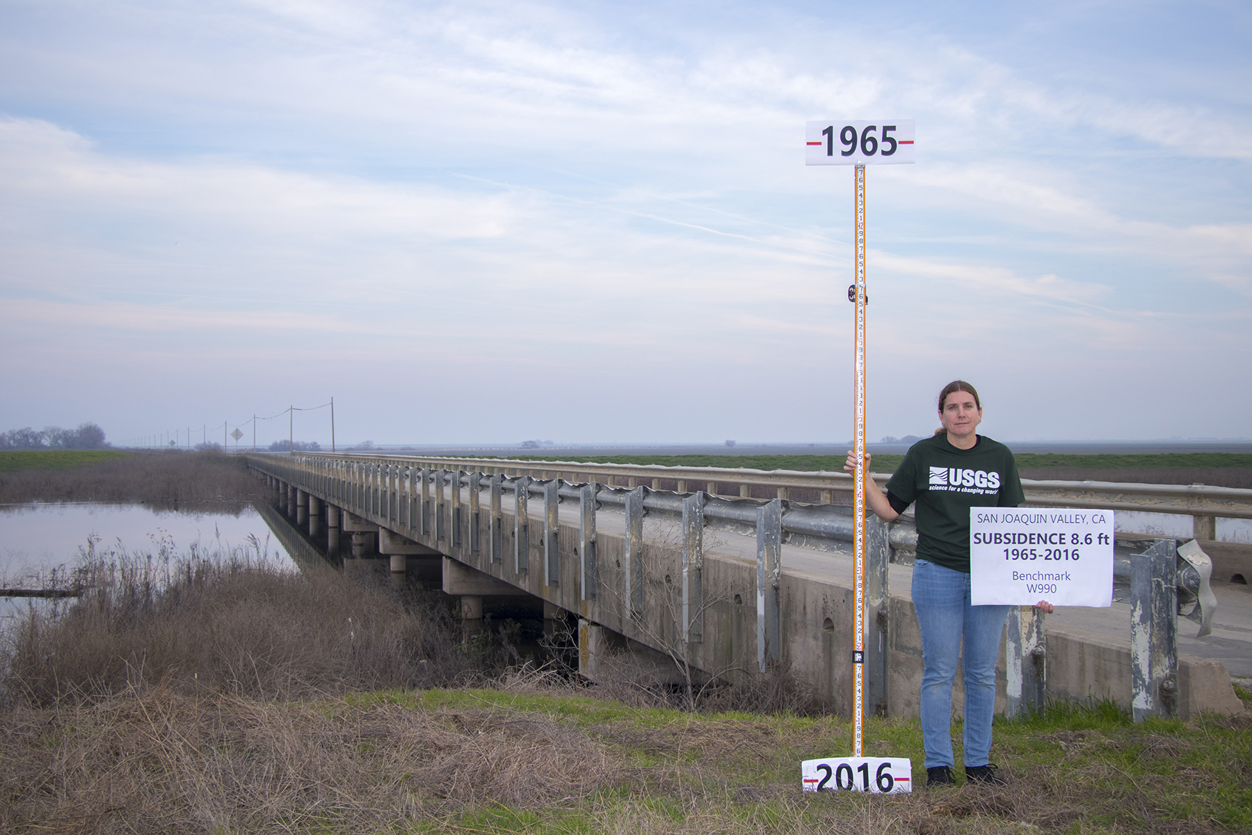
In recent decades, subsidence in the San Joaquin Valley has been most pronounced during periods of drought, when availability of surface water supplies declines and groundwater pumping increases.
Efforts to limit subsidence in the San Joaquin Valley have sought mainly to stabilize existing groundwater levels, on the assumption that preventing further declines in area aquifers would keep subsidence in check. However, recently published research has found that past groundwater withdrawals are likely to continue to cause continued subsidence well into the future, unless hydraulic head is allowed to recover in the affected aquifers.
Subsidence questions
During the 1980s, research on subsidence in the San Joaquin Valley indicated that the phenomenon could continue for decades after the groundwater was withdrawn that precipitated the subsidence, says Matthew Lees, a geophysics Ph.D. candidate at Stanford University and the lead author of the article — titled “Development and Application of a 1D Compaction Model to Understand 65 Years of Subsidence in the San Joaquin Valley” — that was published June 2 on the website of the journal Water Resources Research.
However, studies conducted during the past several years suggested that subsidence would stop relatively quickly (after the precipitating groundwater withdrawal occurs), Lees says — on the order of years, rather than decades. In the face of this discrepancy, the research team of which Lees was a part wanted to “get some certainty on the issue,” he says. At the same time, the researchers also aimed to determine at which depths within the aquifer system the subsidence itself was occurring.
To this end, the researchers combined “satellite-based subsidence data, private well logs, and water level measurements dating back to the 1950s to make a physical model” of the subsurface within an area near Hanford, California, a town in the San Joaquin Valley, according to a June 2 article in Stanford Earth Matters magazine describing the research. The resulting 1D compaction model then was used to simulate subsidence in the area from 1952 to 2017.
Specifically, the model was used to examine the local historical subsidence within the three layers of the alluvial aquifer system that extends throughout the San Joaquin Valley: an upper aquifer, a regional confining unit known as the Corcoran Clay, and a lower aquifer. “Within the upper and lower aquifers is a mix of sediments, which are commonly described as a coarser-grained background containing many clay interbeds,” according to the Water Resources Research article. “Sediments throughout the aquifer system will compact, leading to land subsidence, if there is a drop in hydraulic head within those sediments.”
‘Surprising’ findings
The results of the compaction model largely comported with the scientific understanding of past hydrologic events and how the withdrawal of groundwater directly impacts an area’s hydraulic head, which is essentially the elevation of groundwater above a particular datum level.
Once subsidence has occurred, it cannot be reversed. It can only be slowed or halted.
“We see how known high levels of groundwater extraction in the 1940s, 1950s, and 1960s caused head to decline and subsidence to occur,” according to the Water Resources Research article. “Then, the high availability of surface water in the 1970s caused head to stabilize and, by the 1980s, recover, resulting in a reduction of subsidence rates.”
At the same time, the results for the three decades from 1987 to 2017 were “clearly correlated with declining heads and spiking subsidence rates, with subsidence rates generally low between these events,” the article notes. “Our simulated subsidence therefore fits within the wider hydrologic framework of events in the area.”
That said, the time scales associated with the compaction depicted in the model differed significantly from those of the recent studies that indicated subsidence can be expected to end soon after groundwater withdrawals stop.
“The results from our model suggest that previous studies have significantly underestimated the time constants governing the slow, residual compaction of subsurface clays,” the researchers state in their article. “We suggest that residual compaction of clays is a process that continues for decades-to-centuries, indicating that to significantly reduce subsidence requires some recovery of head, not just a stabilization.”
These findings were “surprising,” Lees says. “We had a sense that we might find the subsidence could be very long-lasting.” Yet the researchers were not expecting that their model would predict that subsidence could continue for “tens, even hundreds of years,” he notes. “We didn’t know we were going to find that. It’s a dramatic finding in terms of groundwater management.”
“Currently, the best practice and the received knowledge is that stabilizing the water levels will stop the subsidence,” Lees says. “Our study really challenges that.”
Groundwater recovery needed
Ultimately, the modeling results appear to indicate that groundwater levels need to recover, and not simply stabilize, if subsidence is to be halted. At first, this finding could seem problematic from the point of view of groundwater users, as it would indicate that groundwater withdrawals have to be curtailed more than originally expected in order to contain subsidence.
Still, the model provided some “good news” on this front, Lees says. “We saw that over the whole study period, the head dropped in the lower aquifer by 40 meters,” he notes. However, during the relatively wet years of 2016 and 2017, the hydraulic head “came back up 10 meters,” he says, or roughly one-quarter of the original decline that caused the subsidence. “Despite the recovery (in hydraulic head) being only about 25%, we actually saw more than a 50% drop in the subsidence rate.”
Of course, the “more recovery you have, the better the drop in subsidence will be,” Lees says. That said, the study results indicate “there is strong evidence that says even a small recovery (of hydraulic head) has a disproportionate gain (in terms of offsetting subsidence),” he explains. “It’s not a one-to-one ratio.”
Informing sustainable management
According to the model, by far most of the subsidence occurred in the lowest of the three layers that constitute the alluvial aquifer system. “Overall, the majority (84%) of subsidence occurred due to compaction within the lower aquifer, with 12% occurring due to compaction in the upper aquifer and about 4% originating from the Corcoran Clay,” according to the Water Resources Research article.
This finding raises the possibility that a shift in pumping from deep aquifers to shallow aquifers could help reduce subsidence by enabling water levels to recover in the deeper layers. Such an option “should at least be a part of the decision-making” as to the depth at which groundwater pumping should occur, Lees says. In particular, such a shift might make the most sense “in places where the subsidence is causing the most costly damage,” Lees says, “particularly near some of the major aqueducts and canals.”
For agencies responsible for groundwater management in the San Joaquin Valley, the findings of the researchers highlight the difficulties associated with trying to address subsidence resulting from activities that occurred in the past, sometimes decades ago, says Eric Osterling, the general manager of the Greater Kaweah Groundwater Sustainability Agency, which has jurisdiction over a 220,000-acre area near Hanford in Kings County and Tulare County.
“We’ve long suspected that there is a residual subsidence phenomenon,” Osterling says. “This report just validates that.” However, the residual nature of the subsidence makes the issue a “hard one to deal with,” he says. “I call subsidence our biggest black box.” To the extent possible, the Greater Kaweah GSA seeks to balance its current groundwater management activities to account for past activities. “There’s a lot of near-term thinking, but there’s a lot of long-term thinking going on too,” Osterling adds.
California and beyond
The compaction model developed for the study could be used to improve groundwater practices elsewhere in California. “The modeling carried out in this study, if done in areas throughout the state, would provide the scientific basis needed to inform sustainable management,” said Rosemary Knight, Ph.D., the George L. Harrington Professor in Stanford’s School of Earth, Energy, and Environmental Sciences and a senior fellow at the Stanford Woods Institute for the Environment, in the Stanford Earth Matters article. “A range of possible actions to mitigate subsidence could be rigorously assessed,” said Knight, who is a co-author of the research paper along with Ryan Smith, Ph.D., an assistant professor at the Missouri University of Science and Technology.
The model also has potential applicability beyond California, Lees says. “Our methodology can be applied to unconsolidated aquifer systems exhibiting subsidence worldwide,” he notes.