By T.R. Witcher
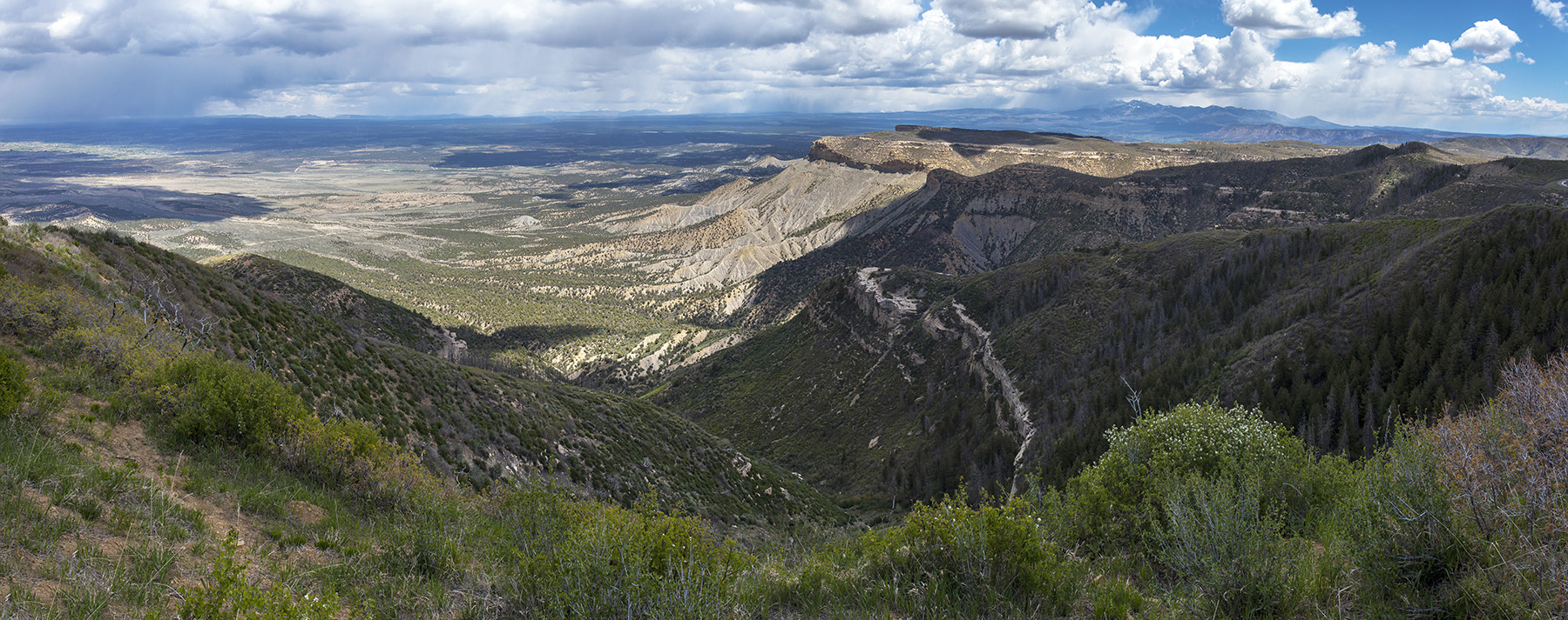
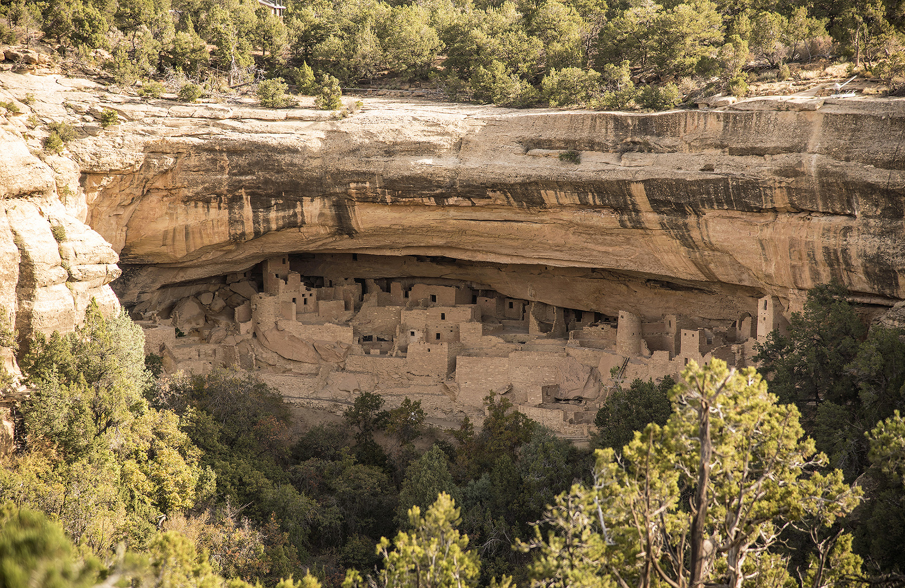
In 1906, Congress established Mesa Verde National Park in southwestern Colorado, one of the oldest national parks in the U.S. and the first to, in the words of then-President Theodore Roosevelt, “preserve the works of man.” The park, situated among an undulating series of canyons and mesas, hosts many wonders of the building arts, pre-serving some 5,000 archaeological sites. These include the massive Cliff Palace, a 150-room structure made of wood beams, sandstone, and mortar that was built during the 12th and 13th centuries.
Mesa Verde is one of the largest remaining sites of the Ancestral Pueblo people, a Native American culture that thrived in the Four Corners region of the American Southwest — where New Mexico, Arizona, Utah, and Colorado meet — from roughly A.D. 500 to 1300, according to water engineer and paleohydrologist Kenneth R. Wright, P.E., L.S., D.WRE. (Water for the Anasazi: How the Ancients of Mesa Verde Engineered Public Works, Essays in Public Works History, No. 22, June 2003.)
But the cliff dwellings were not all the Ancestral Pueblo people crafted. Over the course of several hundred years and commencing centuries before they built the famed cliff dwellings that so astound contemporary visitors, they built and maintained a series of water reservoirs, from roughly 750 to 1180, that helped support a once-thriving civilization. They found ways to create a “sustainable domestic water supply” in a dry land with little surface water, according to an ASCE webpage about the Mesa Verde reservoirs.
Because the Ancestral Pueblo people did not have a written language or use the wheel, Wright argued that historians tended to underestimate their technical acumen. But these ancient Native people possessed “rudimentary knowledge of hydrological phenomena, water transport and storage,” explained Wright.
To Wright, the reservoirs at Mesa Verde are occasions to respect the achievements of these Native Americans in work that required building skill, organization, and the ability across centuries to pass along knowledge and technology. “These capabilities and accomplishments were later manifested in their beautiful and complex cliff-houses,” he wrote.
Archaeologists chart four distinct cultural phases of the Native people who settled at Mesa Verde: Basketmaker III, Pueblo I, Pueblo II, and Pueblo III. Of the four reservoirs at Mesa Verde, the first two, Morefield and Box Elder, were created by the Pueblo I people and built at the bottom of two canyons; they lasted from 750 to 1100 and from 800 to 950, respectively.
By the 10th century, a new group, the Pueblo II people, had migrated to the tops of the mesas and built two more reservoirs: Far View (formerly known as Mummy Lake) and Sagebrush. These were both built around 950 and persisted until 1180 and 1100, respectively.
Wright noted that the builders of the mesa-top reservoirs likely understood the “hydrological acumen” demonstrated by their neighbors or kinsmen in building the canyon-floor reservoirs. They realized that water runoff could be channeled and stored.
Scientists and researchers had been speculating about the presence of water storage at Mesa Verde for decades. In 1892, scientist Frederick H. Chapin described a site (Far View) in Chapin Mesa as a water storage facility. Research and excavation work continued throughout the 20th century, as researchers pondered how the Ancestral Pueblo people could have made use of water storage systems.
Scientists had also long observed the presence of small walls throughout Mesa Verde called check dams, which could control the flow of water and silt and support terraced farming, according to anthropologist Arthur H. Rohn (“Prehistoric Soil and Water Conservation on Chapin Mesa, Southwestern Colorado,” American Antiquity, Volume 28, No. 4, April 1963, pages 441-455).
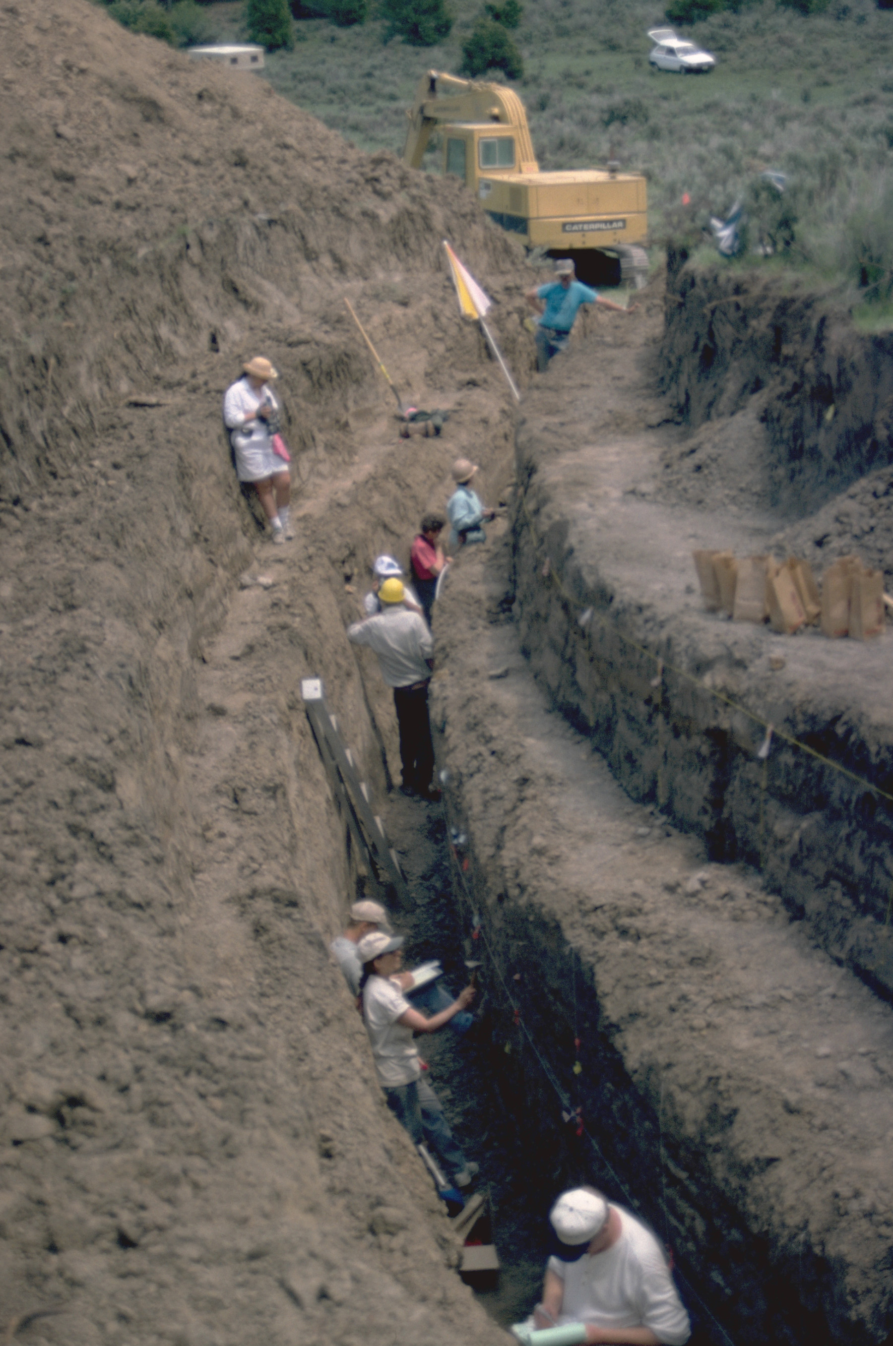
It wasn’t until 1995, however, that Wright led a team of researchers to begin to piece together the mystery of water use at Mesa Verde.
That year, Wright — who had made a name for himself studying the ancient water systems of the Inca at Machu Picchu in Peru — was invited by Mesa Verde park ranger Cynthia Williams to examine the park’s water history. Between 1995 and 2003, the Wright Paleohydrological Institute brought together a wide array of experts to study the site using a variety of techniques, including field topographic surveys, soil augering, surface infiltration tests, geological descriptions, geomorphological analyses, ceramic analyses, paleo climate evaluations, rainfall-runoff determinations, and pollen analyses.
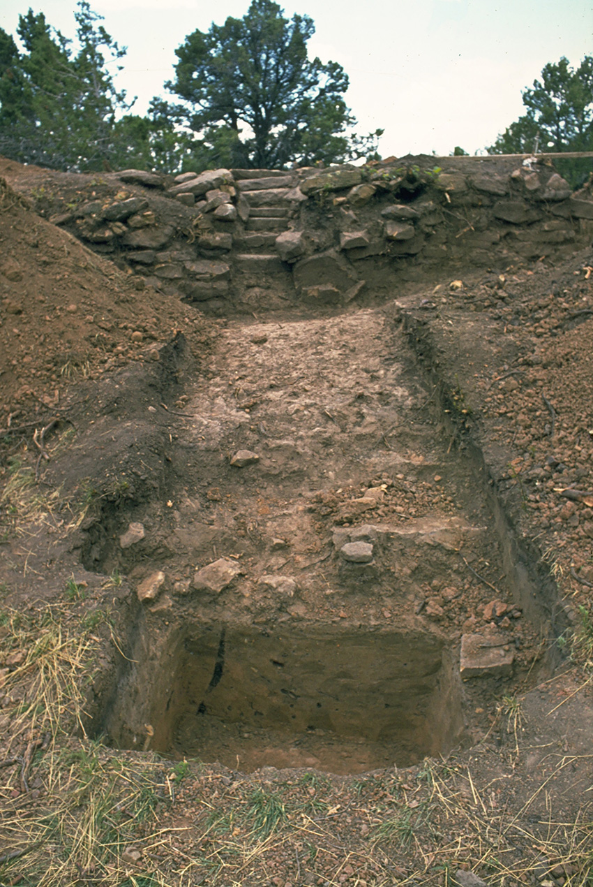
Morefield Reservoir was the first to be examined by Wright and his team. The remains of Morefield are a 16 ft tall, 200 ft diameter mound connected to a taillike structure that Wright likened to the handle of a frying pan.
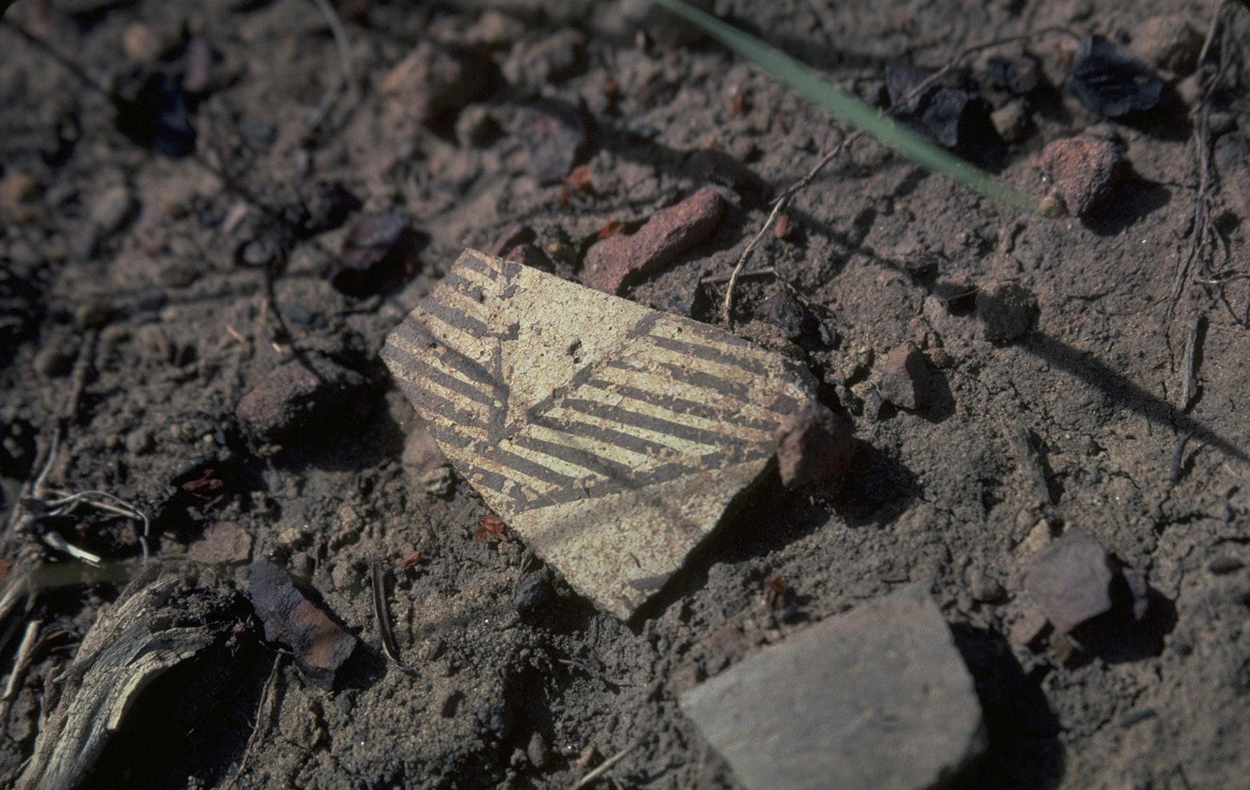
While some scientists thought the site was a ceremonial structure, according to engineer T. Andrew Earles, Ph.D., P.E., D.WRE, in a journal article published by the American Water Resources Association, archaeologists as early as 1929 theorized that the Morefield mound could have been a dam site. One clue that it had been a reservoir: pottery sherds they found in the surrounding area that were used to carry water (“Mesa Verde Reservoirs: Ten Years of Paleohydrology,” Water Resources IMPACT, Volume 7, No. 3, May 2005, pages 9-15).
Wright and his team determined that the reservoir the Ancestral Pueblo people built at Morefield began as an excavated pond, with some of the water in the reservoir coming from high groundwater. Runoff water produced a lot of sediment, and they dredged out what they could. “It was not long until the pond bottom began to rise in elevation and take the form of a mound into which water would no longer flow by gravity,” Wright wrote. “The (Ancestral Pueblo people) determined that water could be diverted from the canyon bottom into a delivery canal leading to the rising pond. But sediment deposits still had to be regularly cleaned out and cast to the side, forming berms.”
By 1100, this slow and steady process of sediment accumulation had raised the reservoir by about 21 ft above its original incarnation as a pond, according to Wright. At the same time, Ancestral Pueblo engineers had to raise the elevation of the delivery canal to match that of the reservoir. Wright cites research by Jack Smith, the former chief archaeologist at the park, who confirmed in 1967 that canal sections were also built over more than 300 years. He adds that “the canal banks were lined with shaped stones to help guard against erosion.”
What is remarkable, however, is that the Morefield Reservoir persisted across centuries. Detailed soil analysis revealed that its ancient engineers contended for 350 years with 14 forest fires and 21 periods of high water flow. But the reservoir, Wright wrote, was watertight because of the dense clays being deposited into it. It was the kind of clay that “modern engineers might use for solid waste site designs to preclude leachate movement.”
Further, “nearby areas that were subjected to busy foot traffic, such as well-traveled paths, the environs of pueblos and upslope agricultural fields, would create runoff from even small rainfalls,” Wright noted. Even a small amount of rainfall, if intense enough, allowed them to harvest water, and ditches they had built channeled runoff to the reservoirs they had dug.
The other three reservoirs are very similar to Morefield. Far View, atop Chapin Mesa, was the second reservoir researchers studied at Mesa Verde. Scientists were vexed by a problem they had considered at Morefield as well: Had there been water at all? According to Earles, soil boring tests between the reservoir walls revealed the presence of maize pollen, which indicated that the watershed had been used for agriculture in the days of the Ancestral Pueblo people. Wright noted that maize pollen could only be “transported by flowing water.”
Sagebrush Reservoir, meanwhile, was constructed in multiple phases starting around 950 and ending around 1100. Its mesa-top location and design were similar to those of Far View. As Wright explained, the ancient engineers dug an initial pond of about 60 cu yd, which was sufficient to store 12,000 gal. However, “over the next 100 or so years … storage would increase to about 40,000 gallons. Sediment and artifacts would be deposited and, over time, the reservoir would become mostly silted,” he wrote.
The fourth major reservoir, Box Elder, was located in Prater Canyon, less than a mile west of Morefield. It was discovered after a fire in 2000 (known as the 2000 Bircher Fire), which, according to Earles, “destroyed much of the vegetation in the canyon bottoms and walls, exposing many archaeological treasures that had previously been hidden.”
Per Wright, the Prater Canyon site was likely created by relatives of the Morefield Reservoir builders who had migrated to the mesa top and needed “to supplement the groundwater supply derived from shallow excavation in the canyon bottom.” Ancient engineers would have excavated a hole to capture groundwater using antlers, digging sticks, flat stones, and baskets. As with the other sites, the reservoir would rise in elevation, and corresponding diversion canals would rise with it.
According to Earles, the discovery of Box Elder Reservoir allowed researchers to conduct a geomorphic analysis of the canyon’s watershed, revealing that wildfires during the times of the Ancestral Pueblo people caused “hydrophobicity of the soil (that) led to greater surface water yield from the watershed” but diminished water quality thanks to “ash, soil and channel erosion,” he wrote. For Earles, this was a reminder that long before modern engineers were thinking about the hydrological impact of wildfires, ancient engineers at Mesa Verde were living those impacts.
Around 1100, the era of reservoir building had largely come to a close. A new era, the Pueblo III era, kicked off as the Ancestral Pueblo people gradually began to leave their homes on the canyon floors and mesa tops for the iconic cliff dwellings. Wright argues that building and maintaining reservoirs was a time- and labor-intensive process (the Ancestral Pueblo people used groundwater sources or natural springs of water in addition to the reservoirs).
Still, according to the National Park Service’s site for Mesa Verde, the Ancestral Pueblo people lived in their spectacular cliff abodes for less than 100 years. A major drought struck the region between 1275 and 1300; after that the population abandoned Mesa Verde and migrated south into what are now Arizona and New Mexico. Theories abound as to why these communities were abandoned: drought and crop failures, the depletion of resources due to intensive use of the land over centuries, or maybe social issues.
“Whatever may have happened, some of today’s Pueblo people, and maybe other tribes, are descendants of the Ancestral Pueblo people of Mesa Verde,” the NPS site notes.
Interestingly, water continued to be an important theme for Mesa Verde in the early 20th century when it took shape as a national park. The 1994 Historic American Engineering Record report (HAER No. CO-79) on the construction of the park’s main entrance road, written by landscape architect Tonia Woods Horton, cites a 1908 annual report in which the park’s first superintendent, Hans Randolph, stressed the importance of building a road to, among other goals, develop a water supply for Mesa Verde. And interestingly enough, many of the laborers employed to build the park’s scenic entry road were Navajo (Reports of the Superintendent of Mesa Verde National Park and J. Walter Fewkes, in Charge of Excavation and Repair of Ruins to the Secretary of the Interior, Washington, D.C.: Government Printing Office, 1908).
These four prehistoric reservoirs were honored as a Historic Civil Engineering Landmark by ASCE in 2004. In his 2003 work, Wright noted that the study of the Ancestral Pueblo people and their water systems was not merely an academic exercise. “I also found that our engineers and scientists who joined the research team would benefit by working with archaeologists, from seeing first-hand the fruits of the work of ancient engineers, and by understanding that the study of ancient civilizations can contribute to making proper choices now, so as to avoid repeating the mistakes of the past,” he wrote.
Writing as far back as the 1960s, Rohn’s perspective on the Ancestral Pueblo people may be useful to us now. “Considered as a whole, the check dams, reservoirs, and ditches represent a major segment of the total material culture still in evidence on the Mesa Verde,” he wrote. “They indicate that water was treated by the prehistoric Pueblos as one of their more valuable resources, and that much (of their) physical and possibly religious energy was expended in assuring an adequate supply.”
In this era of extreme drought in the American Southwest, it is a mindset worth heeding.
T.R. Witcher was a contributing editor to Civil Engineering.
This is my final piece for the History Lesson department. Since taking over in 2016, we have gone on many adventures together across the world: from the Victoria Falls Bridge connecting Zimbabwe to Zambia to the Hagia Sophia mosque in Istanbul. We have also traveled though time, from the construction of World War II airstrips to the sinking of the USS Maine in Cuba to surveying the borders between the U.S. and Mexico.
I appreciate the generous feedback and support from readers over the years. It has been a pleasure writing these stories for you, and I cannot wait to see where History Lesson goes from here.
This article first appeared in the November/December 2022 issue of Civil Engineering as “Harnessing Water: The Ancestral Pueblo People of Mesa Verde.”