By Leslie Nemo
Sprawling over 1,700 acres outside Chicago in Lisle, Illinois, the Morton Arboretum considers itself, first and foremost, a museum — no matter what some of its earliest visitors might have thought. “The general misunderstanding which still exists in the minds of many people in regard to the aim and purpose of the Morton Arboretum leads us to strive to clarify this miscomprehension,” wrote botanist E.L. Kammerer in a 1932 bulletin from the arboretum (Bulletin of Popular Information, Nov. 21, 1932, Vol. 7, Nos. 11-12).
But O.C. Simonds, a landscape architect and civil engineer, believed an arboretum should be more than just a museum. “It should be a work of art, showing to advantage the hills and valleys, with the former emphasized by the growth of tall trees, retaining large open areas so that the
foliage, the sky lines, and the reflections in water can be seen to advantage,” he wrote in a May 22, 1925, article that appeared in an edition of Bulletin of Popular Information.
Simonds, and others of his time, referred to this as the Prairie Style, popular in the Midwest, which sought to emphasize the region’s lush indigenous plantings and wide-open spaces.
Simonds, who designed the arboretum’s grounds, and his successors turned to engineering solutions to coax these valleys, hills, and lakes out of the flat farmland of rural Illinois. While the technology has improved over the past century, the intended vision of the arboretum has stayed the same.
A portion of today’s Morton Arboretum sits on the former estate — Thornhill — of Joy Morton, founder of Morton Salt. Rich off his salt empire, in 1909 Morton bought 1,900 acres of farmland 25 mi west of Chicago. Though it originally functioned as a family home, Morton started planning for roughly 400 acres to become an arboretum within about a decade.
Charles Sprague Sargent, a botanist and the director of the Arnold Arboretum, encouraged Morton in this endeavor. Sargent had been running the Boston facility, which was the first arboretum of its kind in the U.S., when Morton visited as a teenager with his father, Julius Sterling Morton. Sargent, acting as a mentor to Morton, reviewed initial plans for the landscape, came to see the proposed site in Lisle several times, and provided enough advice that Morton claimed that he did not want to become a nuisance in a letter to Sargent.
Sargent also suggested that Morton hire Simonds to guide the layout of the grounds. Simonds was super-intendent of Graceland Cemetery in Chicago, and he had completed projects like the Nichols Arboretum in Ann Arbor, Michigan, when he came to visit Thornhill in the spring of 1921. Within a few months of meeting Morton, Simonds had agreed to take on the project, drawn up a topographical map, and started shaping the new landscape with his design philosophies in mind.
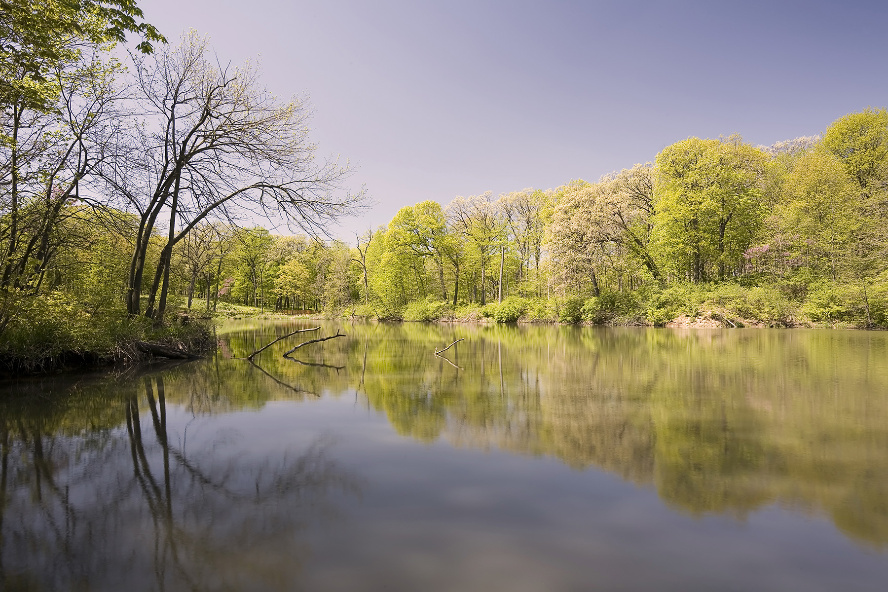
First on Simonds’ agenda was Lake Marmo in the fall of 1921. Named for Morton’s second wife, Margaret Gray Morton, the artificial lake, the first one created on the property, was designed to be an aesthetic feature. The site Simonds chose is located in the former streambed of Willoway Brook, which was a tributary of the DuPage River that ran through the property, according to material from the arboretum.
Teams of mules — driven by Teamsters, an organization that was only about 20 years old at the time — pulled slip scrapers (a kind of supersized shovel with raised sides and back, two handles, and a sharp edge at the front for digging) from the mud and up out of the riverbed after workers had lodged the bladed ends of the devices into the ground.
Workers also carved and filled the land surrounding the artificial lake into small hills, following the gut instinct of Clarence Godshalk, the future superintendent of the arboretum whom Simonds had hired late in 1921 as foreman.
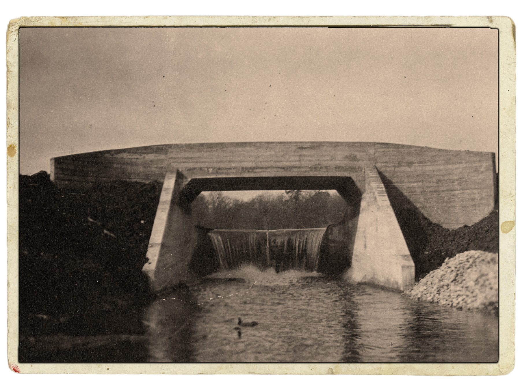
Godshalk finessed the final topography of the hills with a Mormon grader, a device similar to the slip scraper but that moved thinner layers of dirt and felt “like working with a putty knife on sand,” Godshalk said in a lecture detailing the day-to-day operations during construction. To fill the lake, construction crews built a concrete dam and bridge Simonds designed. A nearly identical dredging process played out for another body of water on the site named Lake Jopamaca, which derived its name from the first two letters of the names of the four Morton brothers: Joy, Paul, Mark, and Carl.
Though Godshalk and other employees were technically working from a master plan Simonds had drafted, the finer details of how the team carved up the farming landscape were more freehand. The goal in some of the arboretum’s earliest years, according to Godshalk in a lecture on the arboretum’s evolution, was speed — in part because Morton was 66 by the time Godshalk arrived.
The speedier approach also extended to the project’s internal roadways. Godshalk and Simonds staked out and constructed paths before plotting them on a map to make sure the course would follow the topography and showcase the best foliage the property had to offer. With a roughly marked outline, Godshalk and his crew cleared any greenery from the roadway, sometimes lodging sticks of dynamite into tree crevices to blast the trunks and their roots out of the ground.
A crew member drove a tractor cast off by Morton’s farming operations over the final roadway to smooth it, turning right or left when Godshalk pulled a cord tied to the driver’s arms — a guiding system he adopted since the tractor was too loud to shout over.
Roughly 400 acres of arboretum land opened to visitors in 1923, a few months after Morton settled the existence of the living museum with a trust fund in December 1922. Signed by him and members of his family, the document set up a board of trustees that would invest the returns, which were earmarked to further the work of the arboretum. Though the trustees did not have the power to dispose of any original land, they could accept future financial and land donations.
And accept more land they did. Morton added new acreage to the arboretum once it opened, according to Godshalk, either by handing over some of Thornhill or buying neighboring properties. After Morton’s death in 1934, his family members who inherited stewardship of the property kept up the tradition. By 1937, the arboretum held over 700 acres. Within 15 years, it would be 835 acres, comprising 15 mi of roadway and 25 mi of trails.

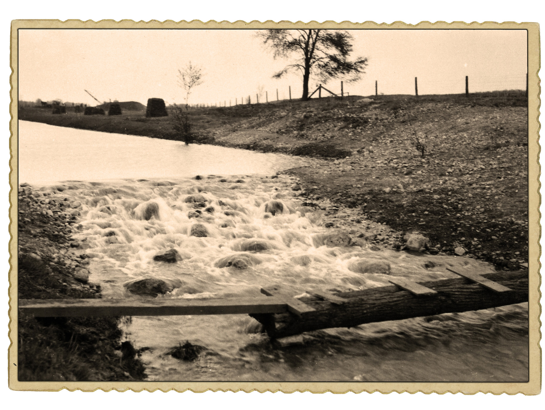
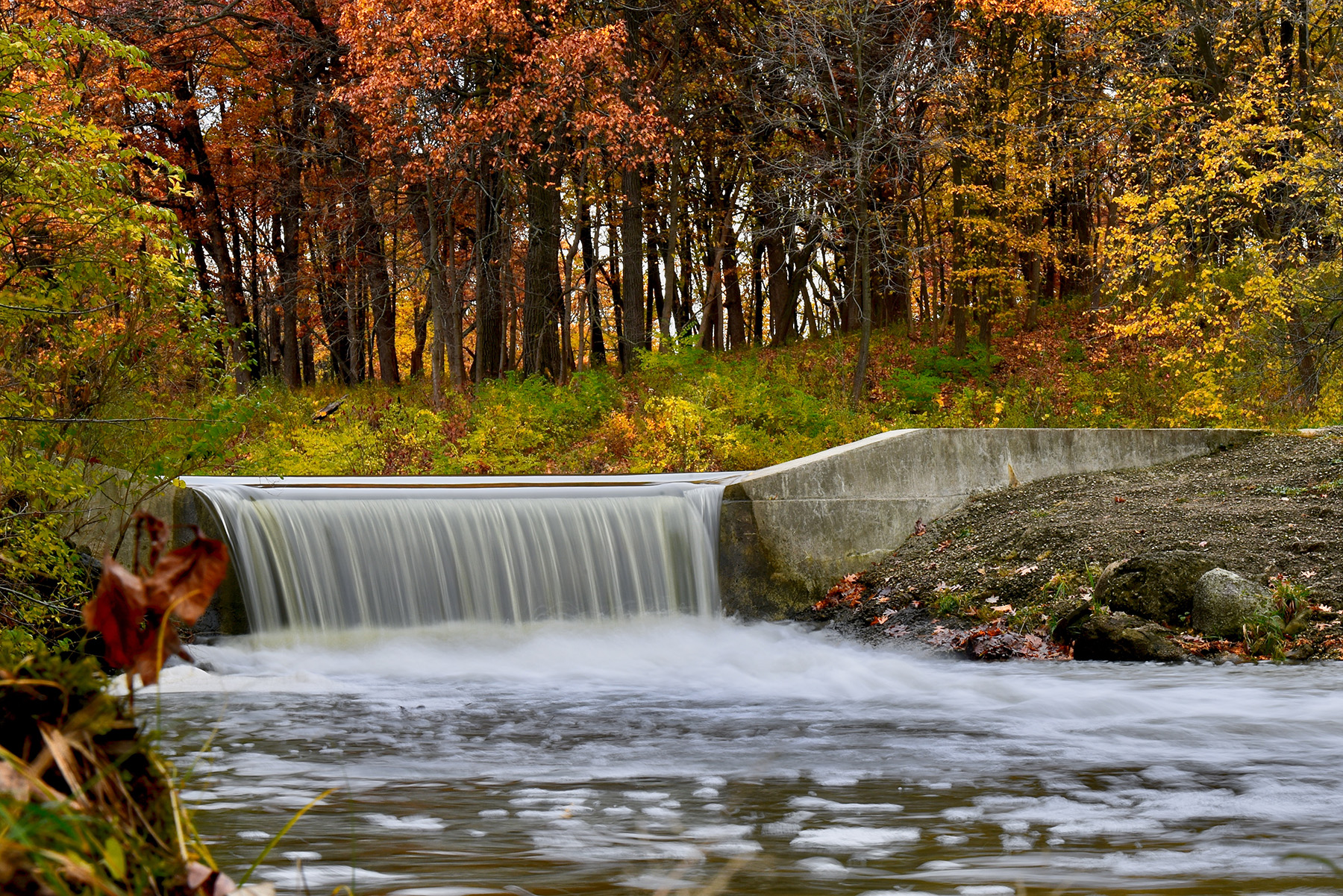
Existing landscape features saw relatively quick changes too. Originally, to fill Lake Jopamaca, workers placed earthen rapids constructed of sod and fence wire in the DuPage River. However, the rapids quickly disintegrated. A decade or so later, workers devised new rapids comprising rocks sunk into soft concrete, though that solution — which lacked a way to control how much water flooded into the lake — was eventually replaced by a gated structure in the 1940s.
In 1940, workers opened the Lake Marmo dam to dredge the sediment collecting at its bottom. Using a dragline excavator, crews hauled more than 18,600 cu yd of black dirt from the lake that they used for future plantings. And in 1960, workers began construction on Sterling Pond, a settling basin to handle the sedimentation from Lake Marmo.
During the planning stages, Morton, an early adopter of the automobile, acknowledged that cars were crucial to viewing the property. He reasoned that, car or not, people eager to see the site would make the trek. The site’s location and sheer size resulted in the arboretum becoming one of the first public gardens with roads that could accommodate cars, according to Cathy Jean Maloney in her book Chicago Gardens: The Early History (University of Chicago Press, Sept. 1, 2008).
But the cars and roadways that Morton embraced also forced his legacy project to transform. Originally, a dirt stretch of public street known as Joliet Road sliced through the property in a north-south direction. Increasingly congested Chicago suburbs pushed Joliet Road into becoming a two-lane highway in 1932. In the 1950s, state and federal authorities expanded the highway, now called Route 53, even further. The two lanes became four, dipping under a new tollway that would run along part of the arboretum’s boundary.
Engineers on the highway expansion project also rerouted the DuPage River where it ran through the arboretum and built a temporary 7 ft wide concrete detour road on the property.
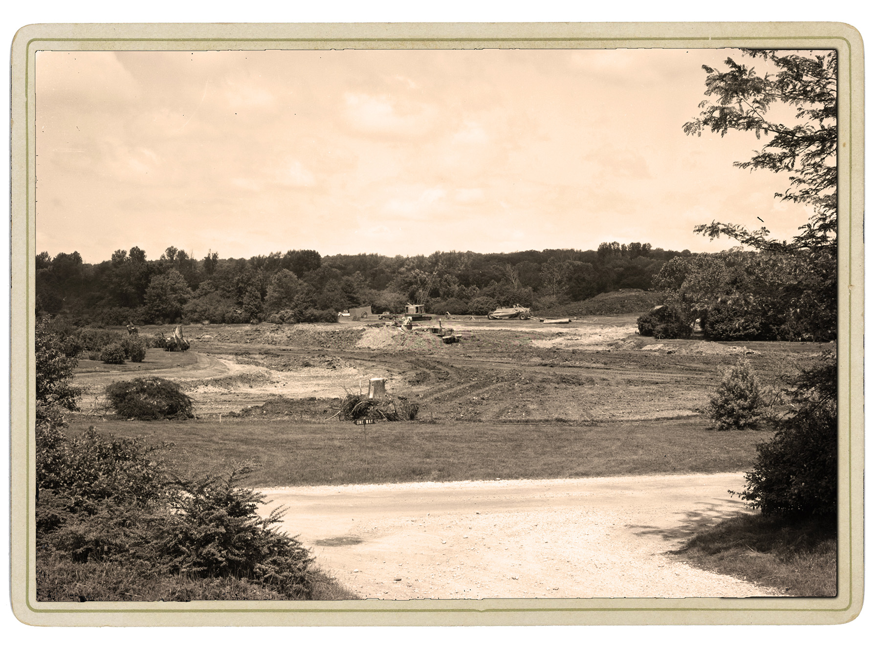
Arboretum staff accommodated the roadway construction first by uprooting and replanting trees — and later by carving new aesthetic features. The site had multiple gravel deposits that construction teams offered to excavate and help transform into new lakes for the arboretum. The extractions were lucrative for the property too.
With the result of several test borings in hand, excavations began in an abandoned cornfield in 1957. As water filled in the excavated site, Arbor Lake was born, the deepest and largest of the site’s lakes, per materials about the arboretum’s construction. According to a letter Godshalk wrote in September 1957, crews removed and stockpiled 1,800 yd of gravel, which was later sold, making a tidy profit for the arboretum.
The second body of water in this phase was Meadow Lake. With its water table at 7 ft underground, the crew installed ditches and used a 24-hour pump to access the gravel for removal. Teams dug out the gravel within the free-form contours that Godshalk had staked out by hand.
Its unique form was due to Godshalk’s vision and desire to keep the site and the lake’s borders as natural looking as possible. He wanted the shape of Meadow Lake to bend in a way that created an illusion. “If you look out the window today over that lake, you’d feel that that lake went way around behind the hills,” he said in a 1978 lecture on the arboretum’s evolution. “That was the idea behind the whole thing — create some mystery.”
More highway frustrations and engineered solutions appeared in the 1980s. The arboretum and its supporters protested — and eventually avoided — the construction of another tollway that would have bisected the property. Instead, the tollway’s proposed location was moved so that it cut through a small portion of the site’s eastern end. While the new tollway went into place, the arboretum added berms to buffer against noise and winter salt spray coming from the tollway built a few decades earlier.
All these features have required further maintenance interventions over the years, says Susan Jacobson, FASLA, PLA, the head of site planning and design at the arboretum. The goal of all the changes, Jacobson says, is subtlety. “With both the landscape design and the engineering design, any project needs to be (unrecognizable) by the average visitor.”
This seamlessness is accomplished by employing “ecologically sound and responsible” methods that prolong the arboretum’s existence and improve its chances of survival, she says. Today, the trust and other forms of income, like admission fees and grants, fund the nearly $43 million operating, research, maintenance, and collections budgets at the arboretum.
As for other improvements, Meadow Lake underwent a draining and re-excavation overhaul in the early 2000s that included the addition of a level spreader, slurry wall, and settling pond to manage lake runoff. New native plantings were added around the perimeter as well. And a nearby parking lot that drained into Meadow Lake was repaved using permeable pavement, says Jacobson. The berms helped shield the arboretum from tollway noise and spray and have seen a number of different plantings over the years as the arboretum searched for salt-tolerant options.
A feature that might depart from arboretum traditions in the coming years would be how people get there, notes Jacobson. Most visitors still access the grounds by car, but “we’re looking at something that’s going to serve us and audiences into the next 100 years. (We are) looking at access for a more diverse audience,” Jacobson says. Possible changes include dedicating a new entryway for bike access, rideshare drop-off, and connections to trains coming from Chicago.
Unlikely to change, however, are some of the initial design principles Simonds crafted. Every decade, the organization checks in with a master plan to assess where the landscape is headed and set new goals. “We want to protect particular sightlines,” Jacobson says. “We want the experience, whether you’re walking on a pathway or driving in a car, to embrace the horizon.”
Leslie Nemo is a journalist based in Brooklyn, New York, who writes about science, culture, and the environment.
References
ACORN and the Collections of the Sterling Morton Library. Various pages.
Ballowe, James. 2016. A Man of Salt and Trees: The Life of Joy Morton. Northern Illinois University Press, DeKalb, Illinois.
Frederick Law Olmsted National Historic Site and the National Park Service. Arboreta and Gardens.
Grese, Robert E. Nearby Nature: O.C. Simonds and the Nichols Arboretum. Library of American Landscape History.
Grese, Robert E. 1999. Simonds, Ossian Cole. American National Biography.
International Brotherhood of Teamsters. The Early Years.
Lohmann, Karl B. 1926. “Landscape Architecture in the Middle West.” Landscape Architecture Magazine, Vol. 16, No. 3, pages 156-168.
Maloney, Cathy Jean. 2008. Chicago Gardens: The Early History. University of Chicago Press, Chicago.
The Cultural Landscape Foundation. 1841-1927 Charles Sargent.
The Cultural Landscape Foundation. 1855-1931 O. Simonds.
This article first appeared in the May/June 2023 print issue of Civil Engineering as “A Living Museum.”