By Matthew J. Jones, P.E., LEED AP BD+C, F.ASCE
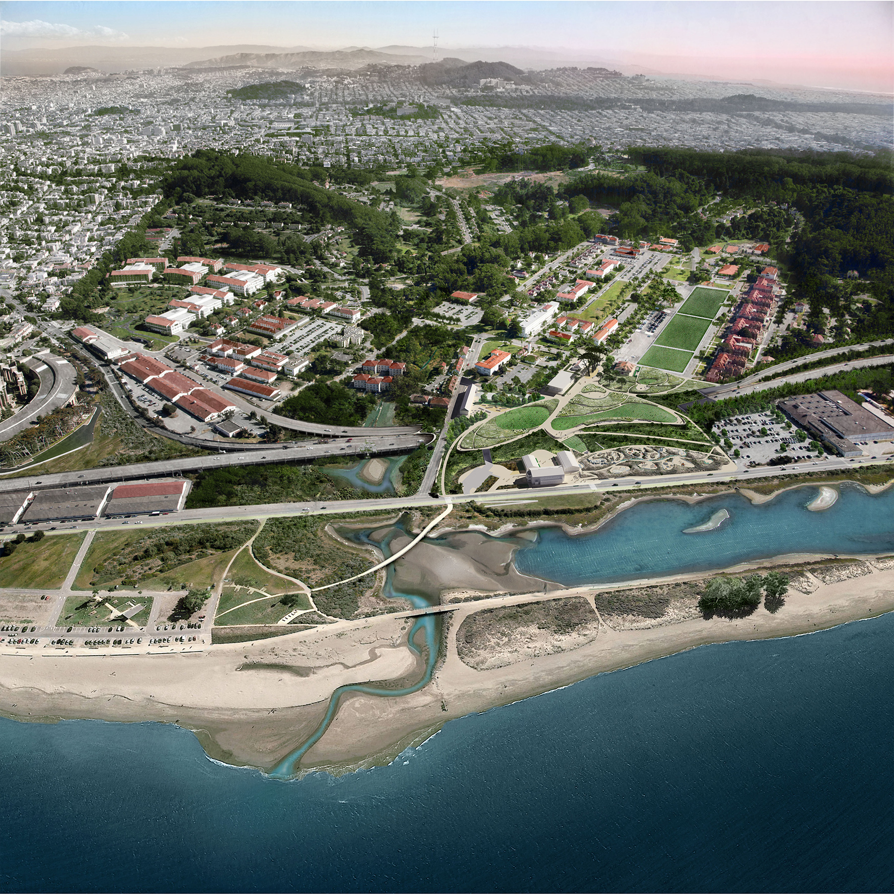
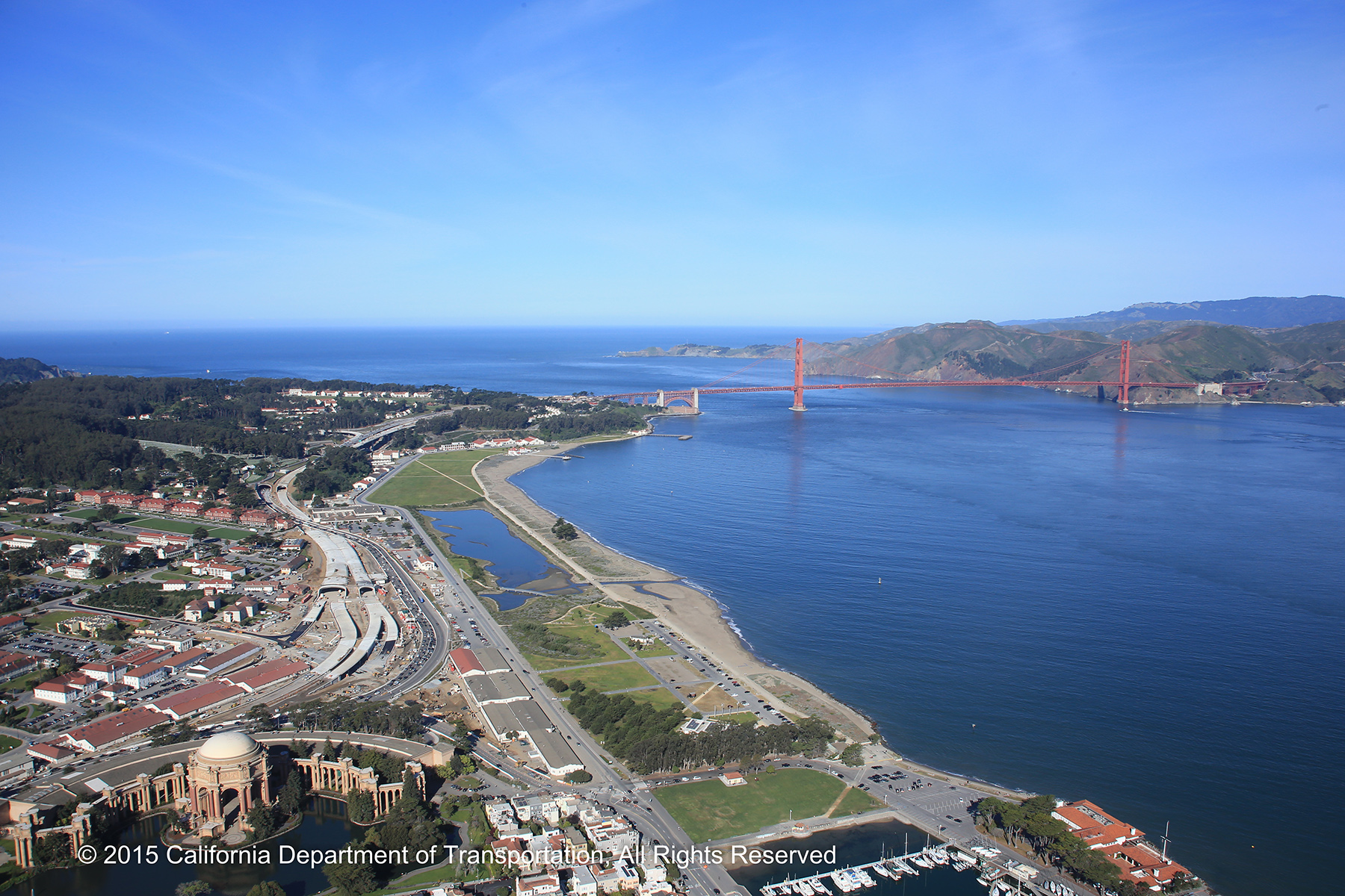
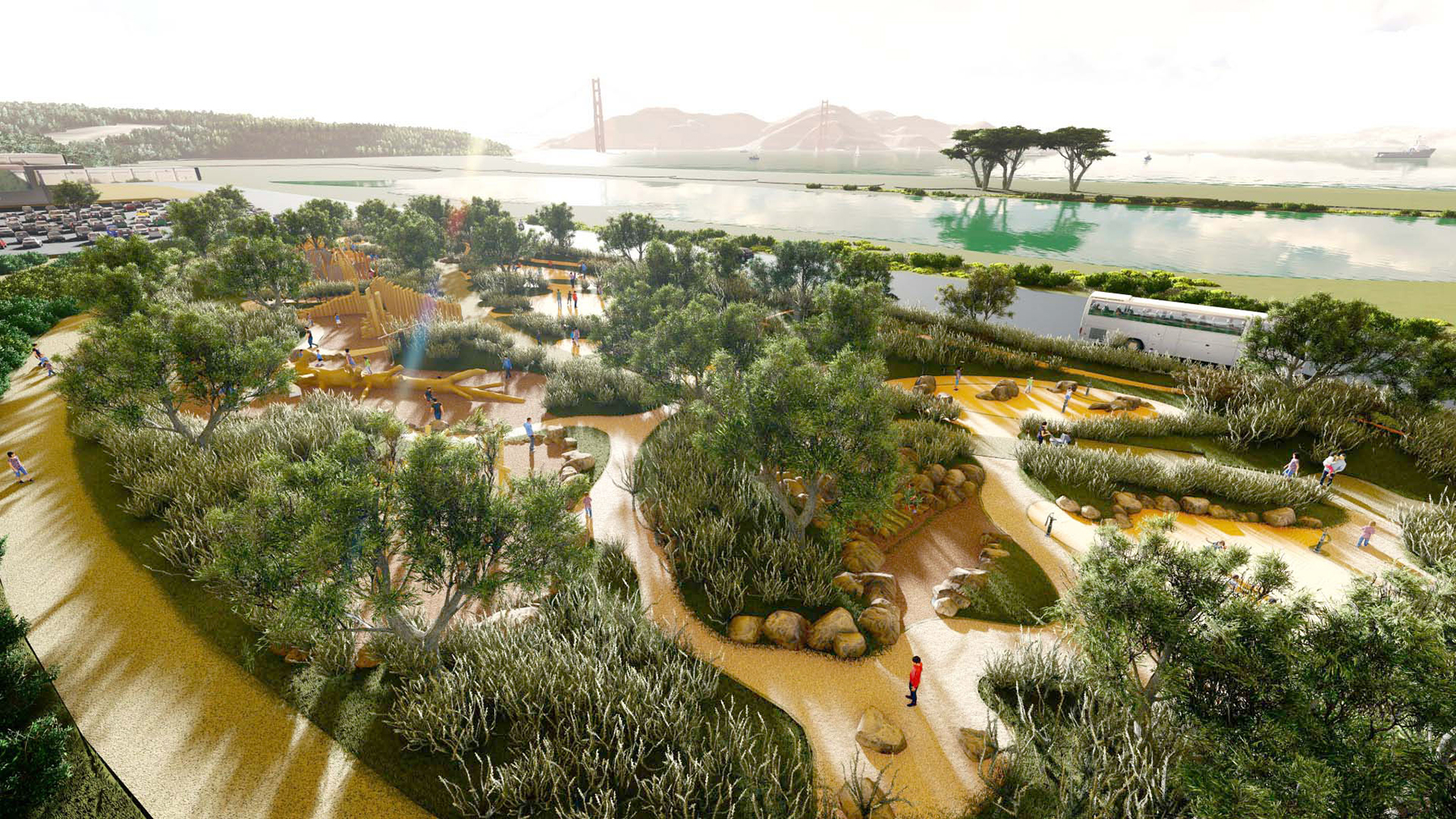
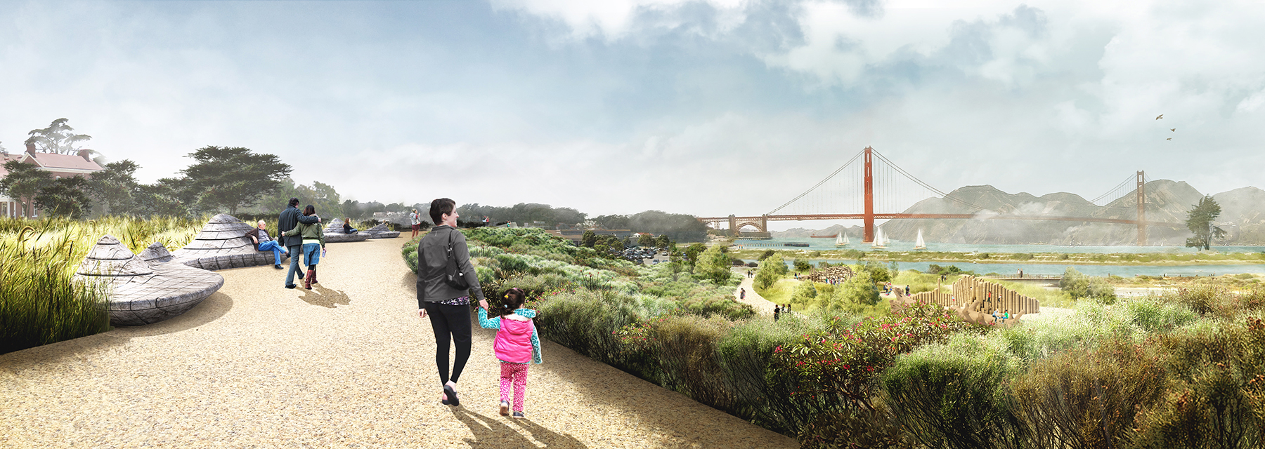
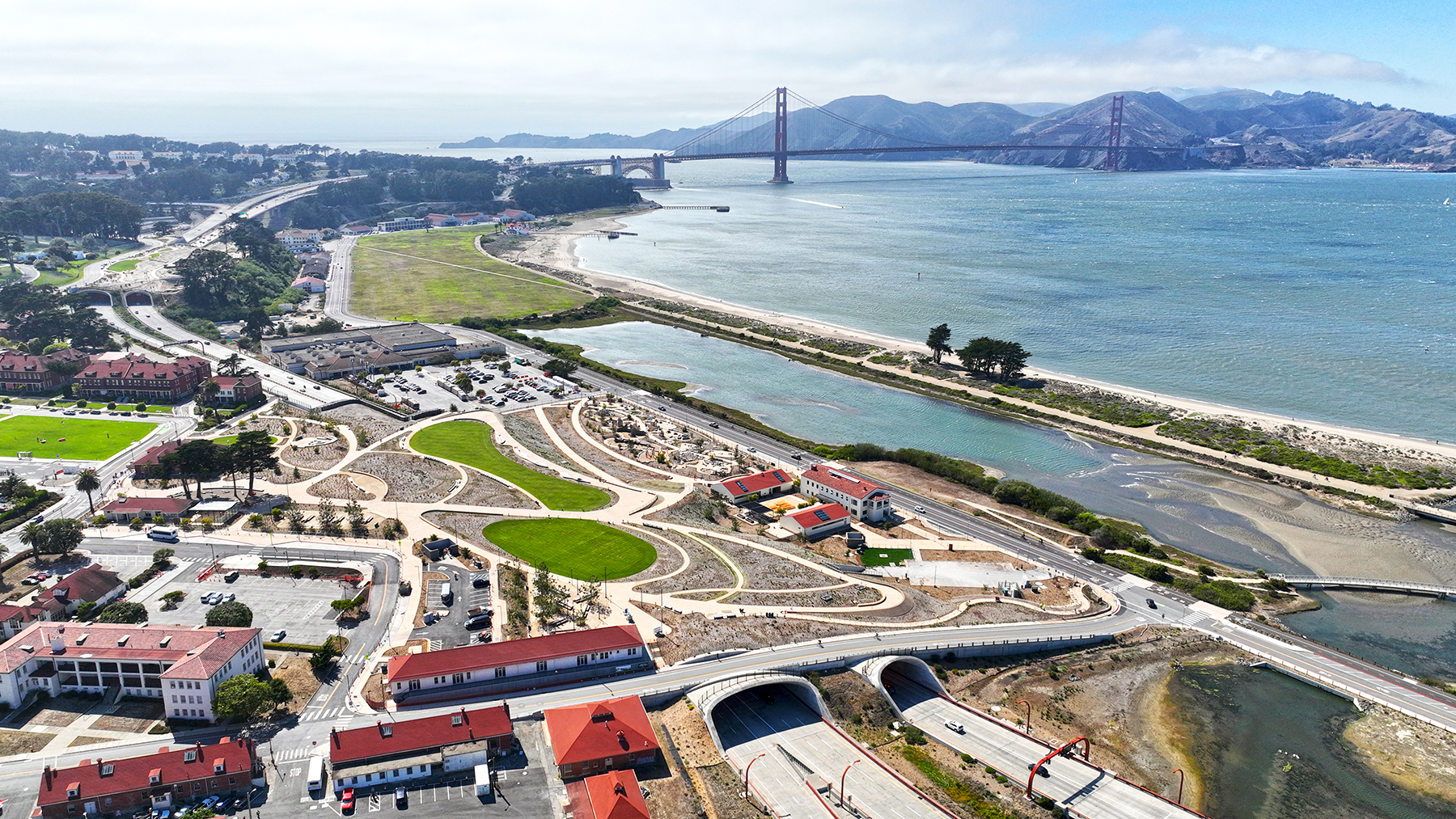
There’s no question that the 1,500-acre historic Presidio of San Francisco national park is special. The same goes for the new 14-acre site within it known as Presidio Tunnel Tops. Situated on a sloping hillside, the $118 million Presidio Tunnel Tops park, which opened to the public on July 17, offers panoramic views of familiar landmarks — the Golden Gate Bridge, Alcatraz Island, Angel Island, the San Francisco Bay, the Marin Headlands, and even the city’s famous downtown skyline. The new park — part of which is atop two new highway tunnels that carry vehicles to and from the Golden Gate Bridge — will provide an unobstructed pedestrian connection between the waterfront and the Presidio for the first time in nearly 80 years.
But long before the first visitors ambled through the new park’s Cliff Walk pathway in July, picnicked on its expansive Central Lawn, or sent their children off to explore the Outpost’s 2-acre, nature-based play areas, civil engineers had to resolve a host of complicated challenges inherent to the site.
Some of these obstacles, such as compressible soils and high groundwater, were common to other waterfront park designs. Unique to the Presidio Tunnel Tops were challenges such as the centuries-old infrastructure unearthed during construction, remnants of its history as a former military post, and the active highway tunnels threaded beneath the site that give the park its name.
While one overarching and important goal was to keep things simple and celebrate the unique qualities inherent to this remarkable site, the teamwork behind the vision was intricate. The project team, which included Magnusson Klemencic Associates as the civil engineer and site structural engineer, combined years of planning, mindful consideration of the site’s topography and history, and proactive collaboration to return the site to a more natural and accessible landmark landscape.
Balancing history with modern civil site design
More than 1,200 years ago, Ohlone and Costanoan people occupied the area we know today as the Presidio of San Francisco and the Presidio Tunnel Tops site. In 1776, Spain recognized the site’s strategic position overlooking the San Francisco Bay and established a military fort — El Presidio is the Spanish term for “garrisoned place.” Forty-five years later, Mexico gained its independence from Spain. The fort flew the Mexican flag until 1847, when the U.S. Army took control of the fort during the Mexican-American War. Almost 150 years later and over the course of two years, beginning in 1994, the post was transferred to the National Park Service, and Congress created the Presidio Trust, which now preserves and administers the park and its historic buildings in partnership with the NPS.
Why is this history important? Before the first spade hit ground in 2018, the design team needed to be aware that creating a public park on the site of a former Native settlement and military base would surely turn up some interesting, culturally significant remains and require a unique level of sensitivity. As a small portion of the overall park, the Tunnel Tops section was no exception.
Contractors found discarded munitions, the foundational ruins of former cavalry stables, a sailing vessel’s bulky capstan, and even a military belt buckle. Similarly, the 1915 Panama-Pacific International Exposition — which was held along the city’s northern shore — left behind ceramic fragments of Asian teacups and redware shards of molded vases. From an archaeological perspective, the site is a treasure — not for its views but for the long-buried remnants in the time capsule of its soil.
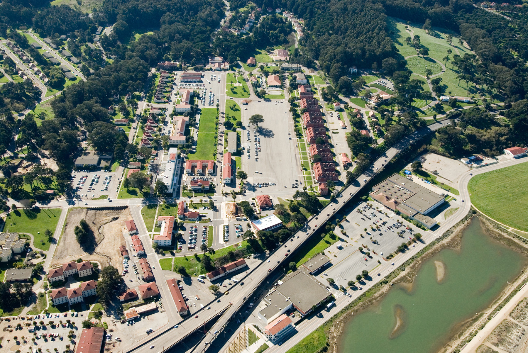
Before there were tunnels, the elevated single-level highway known as Doyle Drive existed. It was built in the 1930s, skirted the military base, and transported vehicles between the Golden Gate Bridge and downtown San Francisco. When the magnitude 6.9 Loma Prieta earthquake rattled San Francisco in 1989, it destroyed a section of the bay area's elevated, double-decker Nimitz Highway located in Oakland. Doyle Drive was not destroyed, but it was later deemed seismically unsafe and rather than taking chances with the next sizable earthquake, city leaders went to work.
In the early 1990s, landscape architect Michael Painter presented an idea to tear down the elevated highway and replace it with cut-and-cover tunnels — which would create new opportunities for open space and pedestrian connections to the waterfront. Community groups rallied around the vision and the California Department of Transportation, also known as Caltrans, undertook the planning and design process for the tunnels that would extend beneath the park. That project broke ground in 2009.
In 2014, a landscape design team that was led by James Corner Field Operations and included MKA was selected to design the Presidio Tunnel Tops. That project broke ground in 2018 while the highway tunnels were still under construction. This created a dynamic process, with two different projects occurring simultaneously on the same site.
This fluid design environment meant all teams — from the Presidio Trust to Caltrans, from Swinerton, the contractor, to James Corner Field Operations and MKA — needed to be engaged, collaborative, and flexible to address the challenges that arose, sometimes daily, while providing solutions that stayed true to the vision for the park above the tunnels.
Overarching design challenges
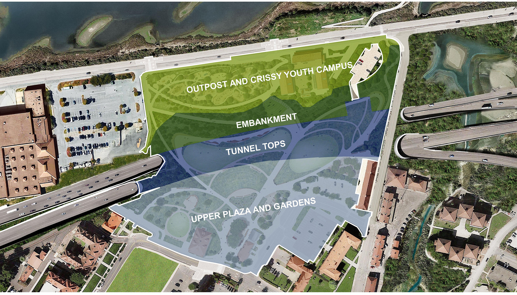
The new 14-acre park includes four interconnected zones:
- The Upper Plaza and Gardens, which includes the Gateway Plaza, with mature cypress trees and flexible seating areas, and the Western Gardens, featuring a cozy campfire circle and wind-protected seating terrace.
-
The Tunnel Tops, which includes the Central Lawn and Eastern Meadows — vast open spaces that conceal and belie the heavily trafficked transportation tunnels beneath.
-
The Embankment, which includes the Western, Central, and Eastern overlooks, offering views of San Francisco landmarks as well as the slope that makes up most of the site’s grade change. The Overlooks are linked by the Cliff Walk, which is furnished with custom-made sculptural wood benches.
- The Outpost and Crissy Youth Campus, which make up a 2-acre, nature-based children’s play area. The Crissy Youth Campus includes a renovated historic building and two new buildings supporting educational programming.
Together, these zones constitute the Presidio Tunnel Tops park, and while each zone had distinct challenges, there were some overall civil design themes that extended throughout the site.
Presidio Tunnel Tops was constructed over various surfaces that settled at different rates — from the hard structures of the tunnels to the soft and compressible soils associated with the nearby bay and its well-known Bay mud and the improved ground containing new stone columns. A suitable “foundation” was needed to support the weight of the park’s new features and address the potential of differential settlement among the various surfaces.
To mitigate differential settlement, the site was preloaded with surcharge soil built up to the future finish grade. Through careful earthwork calculations and close collaboration with the contractor, a soil sequencing dance was choreographed. The first step overburdened areas susceptible to settlement with on- and off-site material. The added weight compressed the soil and allowed the ground to settle prior to further work taking place. (On-site material was borrowed from areas that weren’t susceptible to differential settlement, after which the material was moved to its final location.)
All four zones contained restrictions on how far beneath the surface structural foundations for walls, lights, furniture, and play features could extend so as not to disturb the tunnels, Caltrans-placed geogrid reinforcement, or sensitive archaeological areas. This required close collaboration among James Corner Field Operations as the landscape architect, MKA as the civil and structural engineer, and Miller Pacific Engineering Group as the geotechnical engineer to identify the site constraints before developing innovative location-specific foundation designs that minimized the depth of disturbance.
The tops of the newly built tunnels and the existing surface parking lots made the site predominantly impervious. To address this, the design incorporated a landscape-based stormwater management approach to restore the site’s historical hydrologic function and direct stormwater runoff from hard, impervious surfaces into landscaped zones, where it could be cleansed and its velocity reduced as it traveled through vegetation and soil.
This approach also provides passive irrigation before the water infiltrates, evapotranspirates, or discharges into the storm drain system.
Finally, a fundamental project goal was for visitors of all abilities to experience the full breadth and depth of the park’s recreational offerings — from the Upper Plaza and Gardens above to the Outpost below. The site contains approximately 40 ft of grade change from the 800 ft between its upper end to its lower reaches, and the design also needed to accommodate maintenance and emergency vehicles serving the park and the tunnels. As a result, a carefully coordinated, Americans with Disabilities Act-compliant path system was developed to provide access to all corners of the site, with hardscape capable of supporting the design vehicles.
Individual challenges
While those are some of the larger, macro challenges and solutions of the Presidio Tunnel Tops project, the four zones — the Outpost and Crissy Youth Campus, the Embankment, the Upper Plaza and Gardens, and the Tunnel Tops — presented individual challenges, given their distinctive characteristics, terrain, and use.
Outpost and Crissy Youth Campus: Liquefaction and water intrusion
Historically, the Stream Ravine and Tennessee Hollow watersheds served as natural outfalls for water flowing from the Presidio’s upper reaches to the waterfront, which is now the site of the Outpost and Crissy Youth Campus. Over time, the Stream Ravine was consolidated into a single, closed conduit with a manual tide gate to prevent saltwater from surcharging the storm drain system and backing up into the site during tidal fluctuations.
The park’s design needed to account for the fact that this area is relatively low in elevation and consists of sensitive archaeological zones, Bay muds prone to liquefaction in earthquakes, and high groundwater that is projected to rise with climate change. As such, the design needed to protect the site from sea level rise and saltwater intrusion, protect the site from rising groundwater, and create capacity within the site to store stormwater until the tide subsides.
These challenges were addressed by incorporating two design interventions.
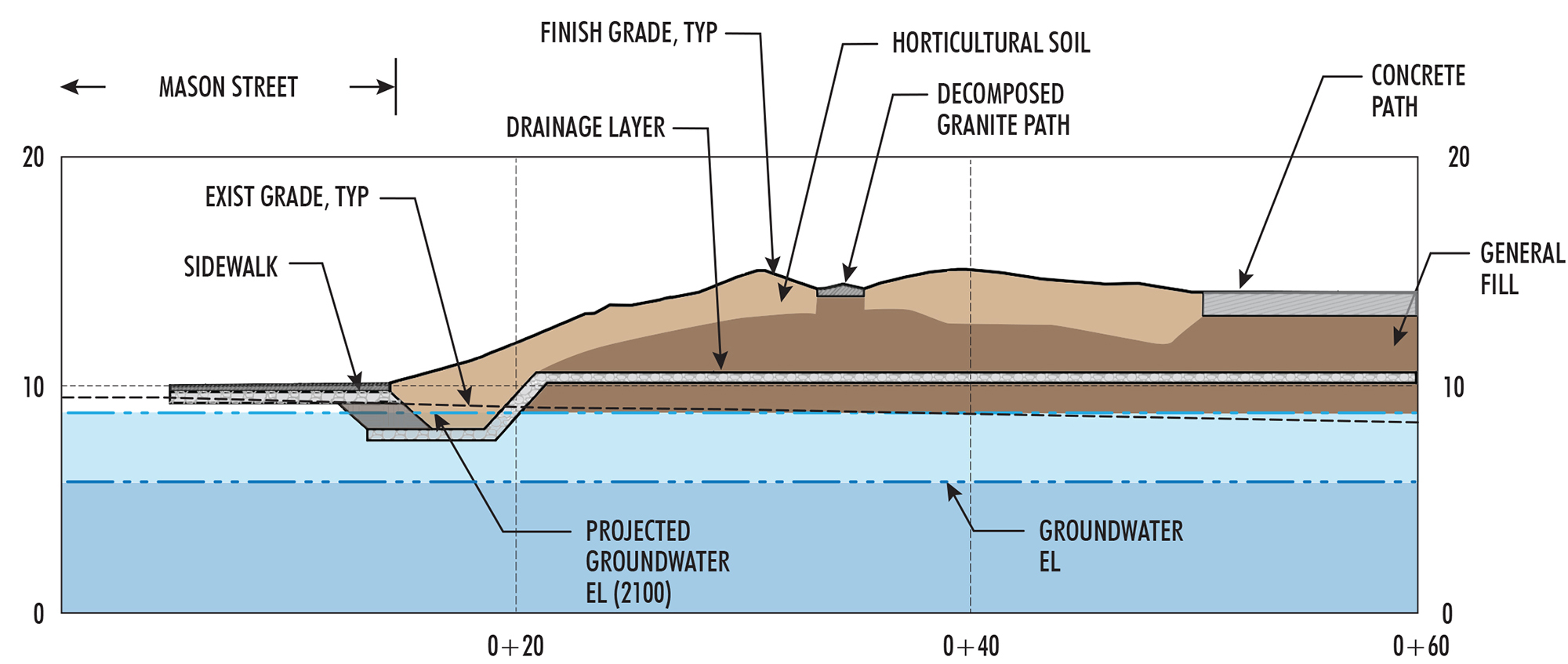
First, the ground elevations were raised to protect the site from overland saltwater flows while keeping it above the future groundwater elevation and sensitive archaeological zones. This buildup consisted of an aggregate drainage layer that doubled as a capillary break to prevent the movement of water, which was topped with a base layer of general fill overlain with horticultural soil to support the planting palette.
Second, the manual tide gate was replaced with passive backflow prevention devices. These devices protect the site from subsurface saltwater intrusion through the storm drain system, eliminating the need for manual deployment. The voids of the landscape soil, drainage layer, and pipe system are used for water storage to hold runoff on-site until the tide subsides and the site can drain.
Embankment: Grade and stability
The vision for the Embankment was to create a stable, landscaped slope at the base of the Overlooks, mimicking the site’s historic bluff while including accessible pathways, stairways, and viewing terraces. This zone contains most of the site’s grade change and is supported from below by the improved ground containing stone columns that were installed by Caltrans. In addition, Caltrans installed a geogrid rock sandwich at the bottom of the Embankment to address global stability, which became affectionately known as the Big Mac.
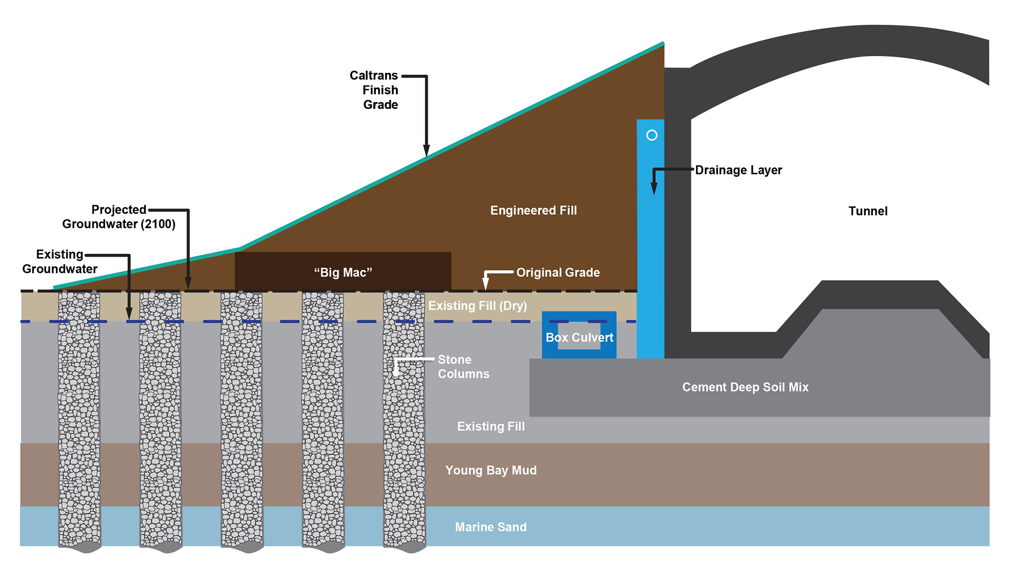
This zone’s primary challenges were threefold: mitigating the potential for differential settlement as the slope extends from the hard surfaces above the tunnels over unimproved ground to the stone columns below, building a stable slope on top of Caltrans’ tunnel-top slope capable of sustaining vigorous plant growth, and addressing surface and subsurface drainage to prevent erosive activities or undermining of soil stability.
These challenges were addressed through integration of the following solutions.
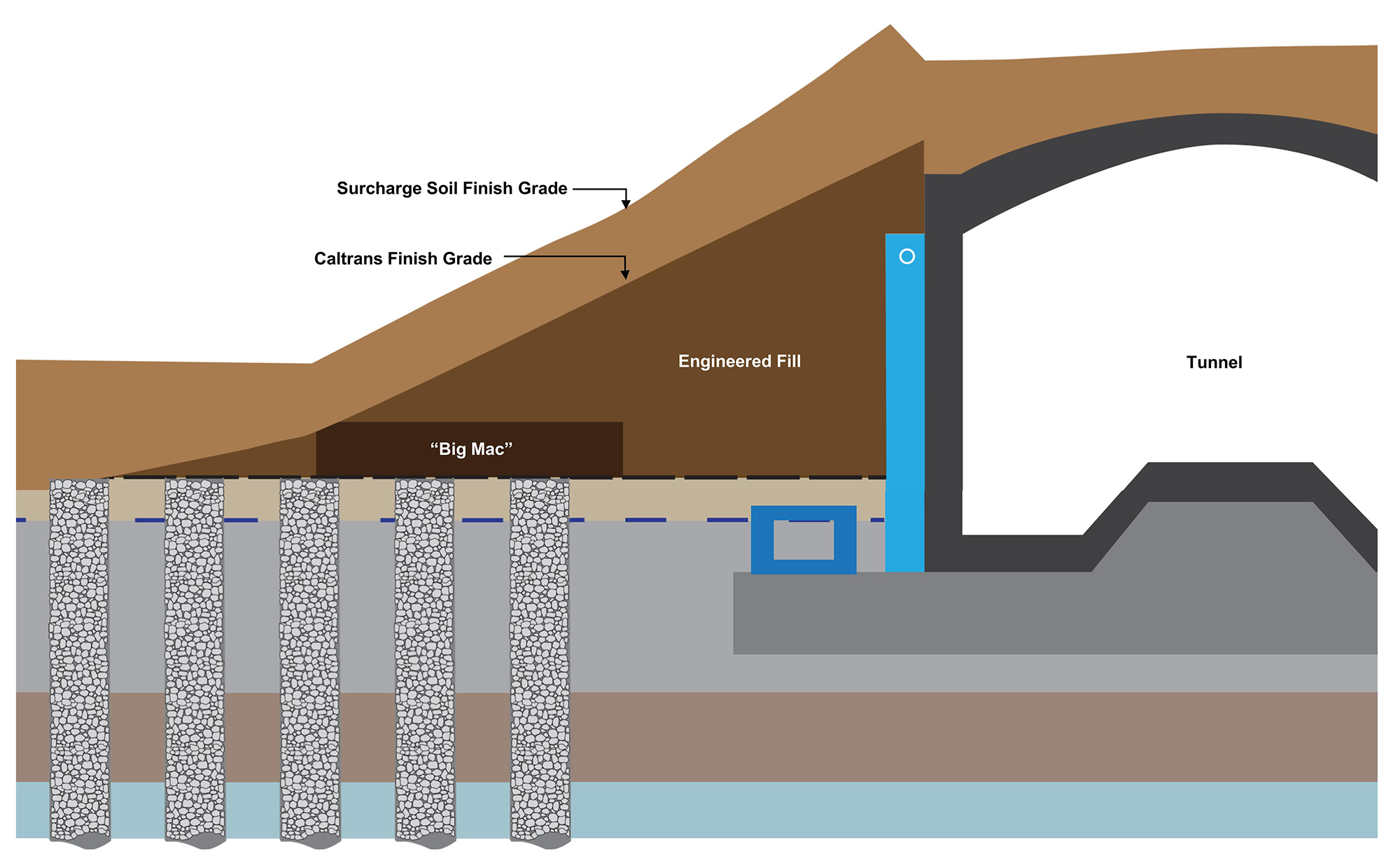
First, the Embankment, Outpost, and Crissy Youth Campus were surcharged to compress the soils and squeeze water out of the voids to address differential settlement. During this process, Miller Pacific was closely involved as the team collaborated on the quantity of soil to place, the angle of the temporary slopes, and the duration to leave the overburdened material in place. When the settlement sufficiently slowed, the surcharge soil was removed and placed in areas that were prepared to receive it.
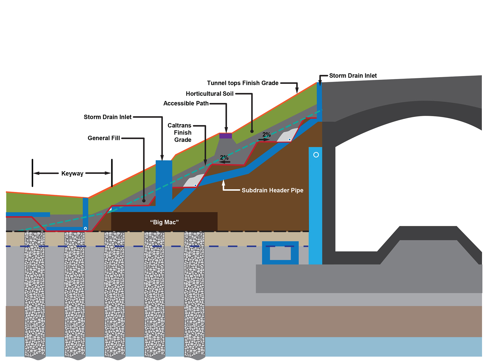
Second, the design team worked carefully with Caltrans to design a system over and around the tunnel improvements as well as construct the park’s slope on top of Caltrans’ slope without undermining its integrity.
A “keyway” was developed at the bottom of the slope to hold back the uphill layers. The keyway was designed to receive subsurface drainage from the new slope and surgically tie into the storm drain system at strategic locations without disturbing the Big Mac. A series of benches above the keyway and Caltrans’ geogrid layers backslope to subdrains to minimize the downslope movement of subsurface water. The subdrains connect to downslope collection pipes that convey the water down the slope to the keyway.
The design vision called for the Embankment topography to resemble the historic bluffs found within the Presidio of San Francisco while accommodating visitors of varying abilities by offering lawn terraces and pathways sculpted into the hillside to connect the upper and lower levels.
Tunnel Tops: Loading restrictions
In the Tunnel Tops zone, the project team envisioned a central path, the Cliff Walk, extending from the Main Promenade to the Western, Central, and Eastern overlooks.
This zone’s primary challenge was the loading restrictions of the tunnels, the tunnels’ utility infrastructure, and the maintenance vehicle access requirements.
These restrictions were addressed by incorporating multiple design interventions.
First, the design was informed by the tunnel vents, utility structures, and turning-movement studies for maintenance and emergency vehicles.
Second, the design team settled on the right combination of materials so that it could incorporate a subsurface gravel notification layer to alert future excavators of the tunnel top structure’s proximity, install a general fill layer to build up to the desired finish grade elevations, import horticultural soil to support the proposed planting palette, construct pavement sections capable of accommodating pedestrian and vehicle loading, and provide enough flexibility to account for live loading associated with pedestrians, vehicles, events, and other activities.
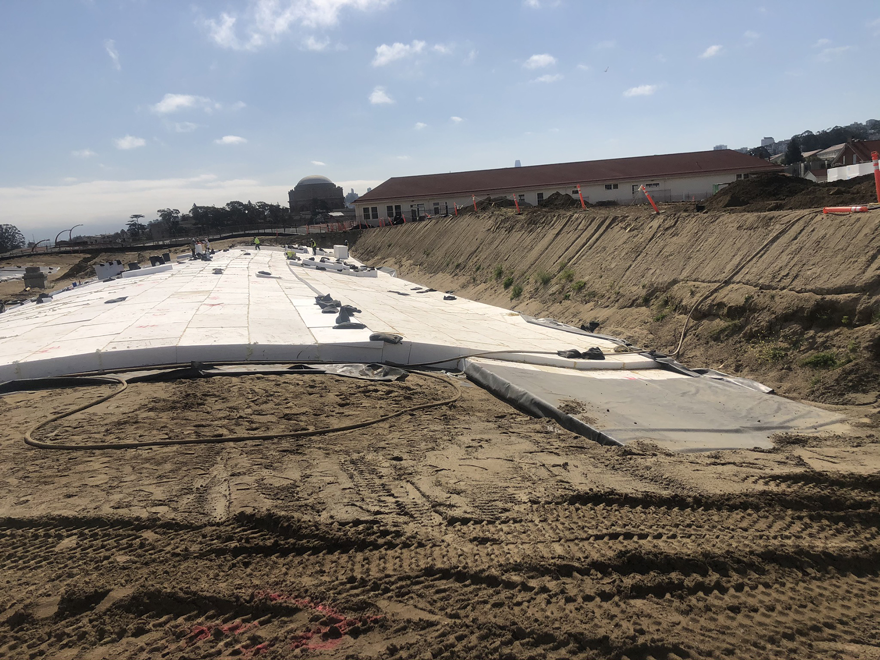
After extensive loading analyses informed by the site plan, grading plan, and Caltrans’ tunnel design and calculations, MKA determined that lightweight geofoam should be used in several locations to reduce the added dead weight on the tunnels and stay within Caltrans limits while providing enough live load capacity to support the proposed public assembly activities.
Upper Plaza and Gardens: Preserve, recharge, and protect
Finally, the challenges associated with the Upper Plaza and Gardens zone involved two archaeologically significant areas relatively close to the ground surface, permeable soils that provided an opportunity to recharge the groundwater, and a stand of 150-year-old Monterey cypress trees that were to be protected and remain in place.

To address these challenges and comply with federal stormwater retention requirements, three subsurface gravel infiltration galleries were designed to store stormwater within the voids of the aggregate. These infiltration galleries required pretreatment to prevent the migration and buildup of fine sediments that could reduce the storage capacity over time. Paved surfaces were sloped toward landscape areas where water is filtered before entering the infiltration galleries where the water is dispersed amongst large, clean stones. If a storm is more intense than the soil’s infiltration capacity, the water will rise in the gallery until it reaches the overflow elevation, at which point the water will enter the storm drainpipe system with an outlet in Crissy Field Marsh.
Amplified visitor experience
The Presidio of San Francisco has always been a beautiful place with extraordinary views and a dynamic history. Presidio Tunnel Tops presented an opportunity to amplify the visitors’ experience by using the site’s unique location to heighten the existing and dramatic panoramic views and make them accessible to all. In addition, the design team honored the Presidio’s historical context and singular ecological landscape in the new park’s design.
In the end, the Presidio Tunnel Tops design required importing more than 50,000 cu yd of subgrade soil and 43,000 cu yd of horticultural soil to sustain 200,000 plants, half of which are native to the Presidio.
Each zone of the Tunnel Tops was an integral piece of the cohesive whole that, added together, created a truly incredible park. A collaborative team effort to respect the site’s historical and cultural significance, avoid sensitive areas, and preserve the function of the newly constructed tunnels resulted in a truly world-class destination that everyone can experience.
Matthew J. Jones, P.E., LEED AP BD+C, F.ASCE, is a senior principal in the Seattle office of Magnusson Klemencic Associates.
PROJECT CREDITS
Owner: Presidio Trust
Prime consultant and landscape architect: James Corner Field Operations
Civil and site structural engineer: Magnusson Klemencic Associates
Architect: EHDD
Water feature consultant: Fluidity Design Consultants
Mechanical, electrical, and plumbing engineer: PAE
Building structural engineer: Holmes Structures
Soil scientist: Wallace Laboratories
Irrigation consultant: DD Pagano Inc.
Geotechnical engineer: Miller Pacific Engineering Group
General contractor: Swinerton
This article has been updated to clarify that the section of the Nimitz Highway damaged in the Loma Prieta earthquake was in Oakland.