By Jay Landers
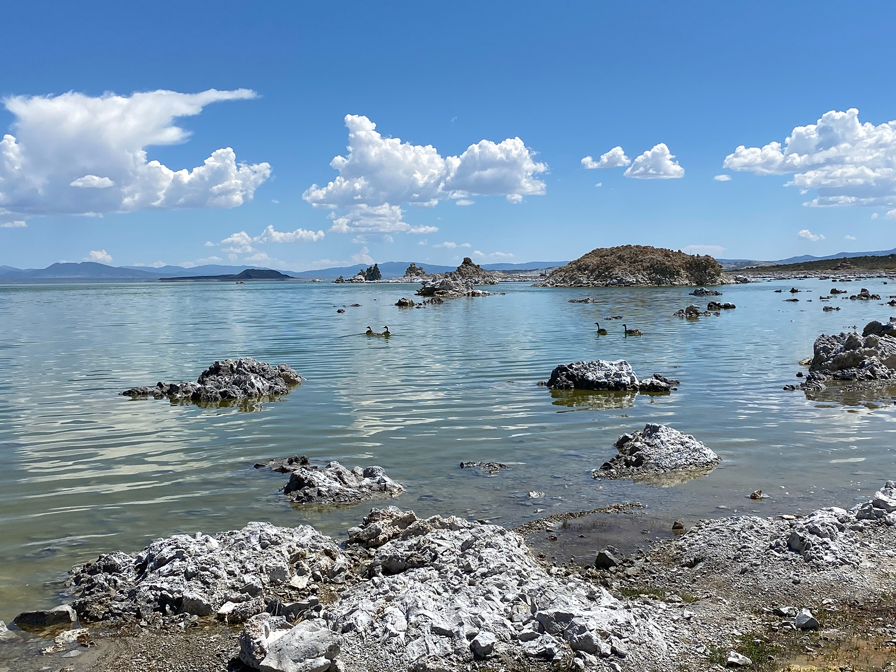
In 1940, the Los Angeles Department of Water and Power completed the Mono Basin Extension of the Los Angeles Aqueduct, the famed system finished in 1913 to convey water by gravity more than 230 mi from the Owens Valley on the eastern slope of the Sierra Nevada to Los Angeles. With the extension, the LADWP began diverting runoff in 1941 from four streams that feed Mono Lake, an ancient terminal water body measuring roughly 9.3 mi length and 13 mi in width in the eastern Sierra Nevada that provides a unique habitat for wildlife due to its salinity and remote islands.
The lake is one of the oldest in North America and is near the community of Lee Vining and Tioga Pass, the eastern entrance to Yosemite Valley.
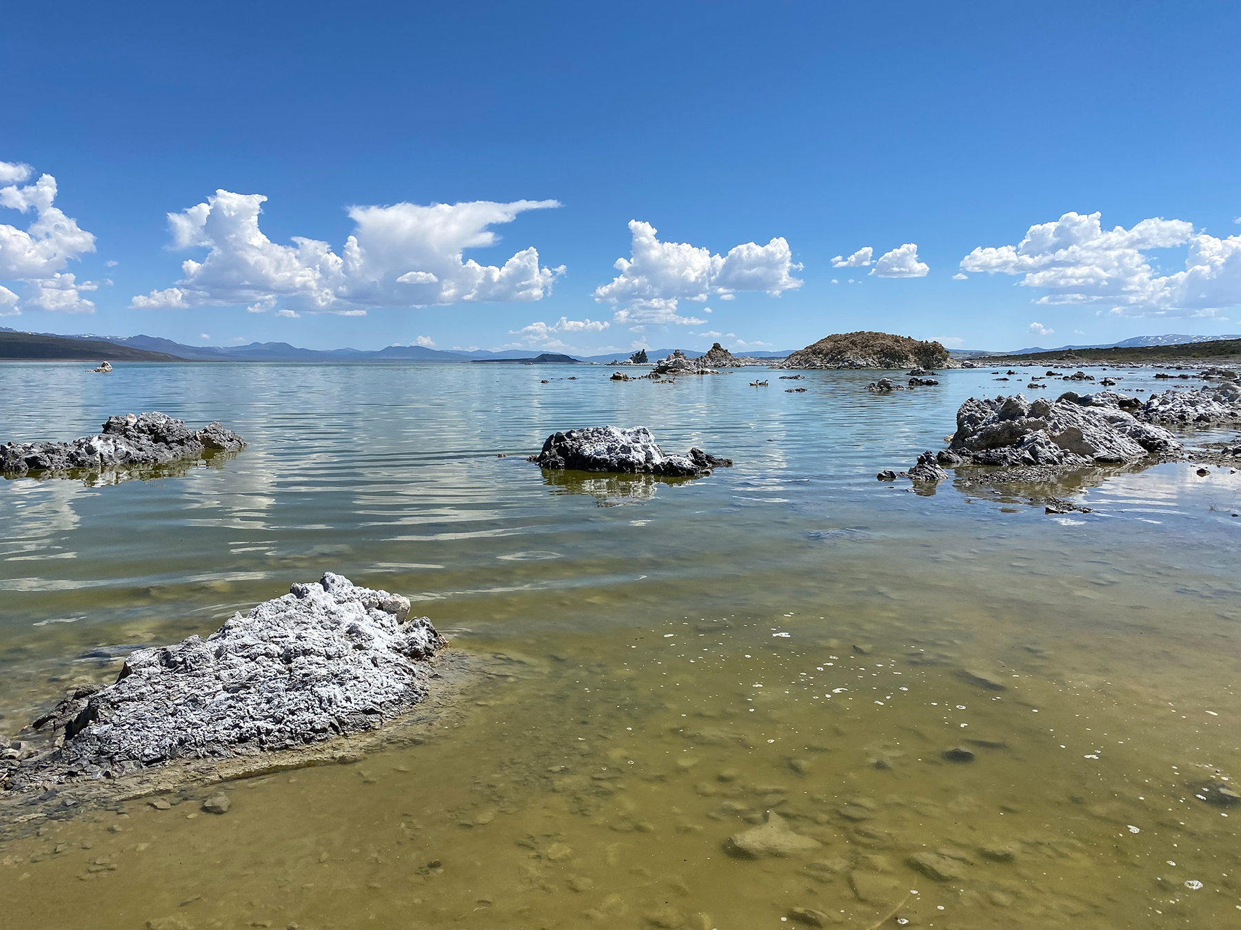
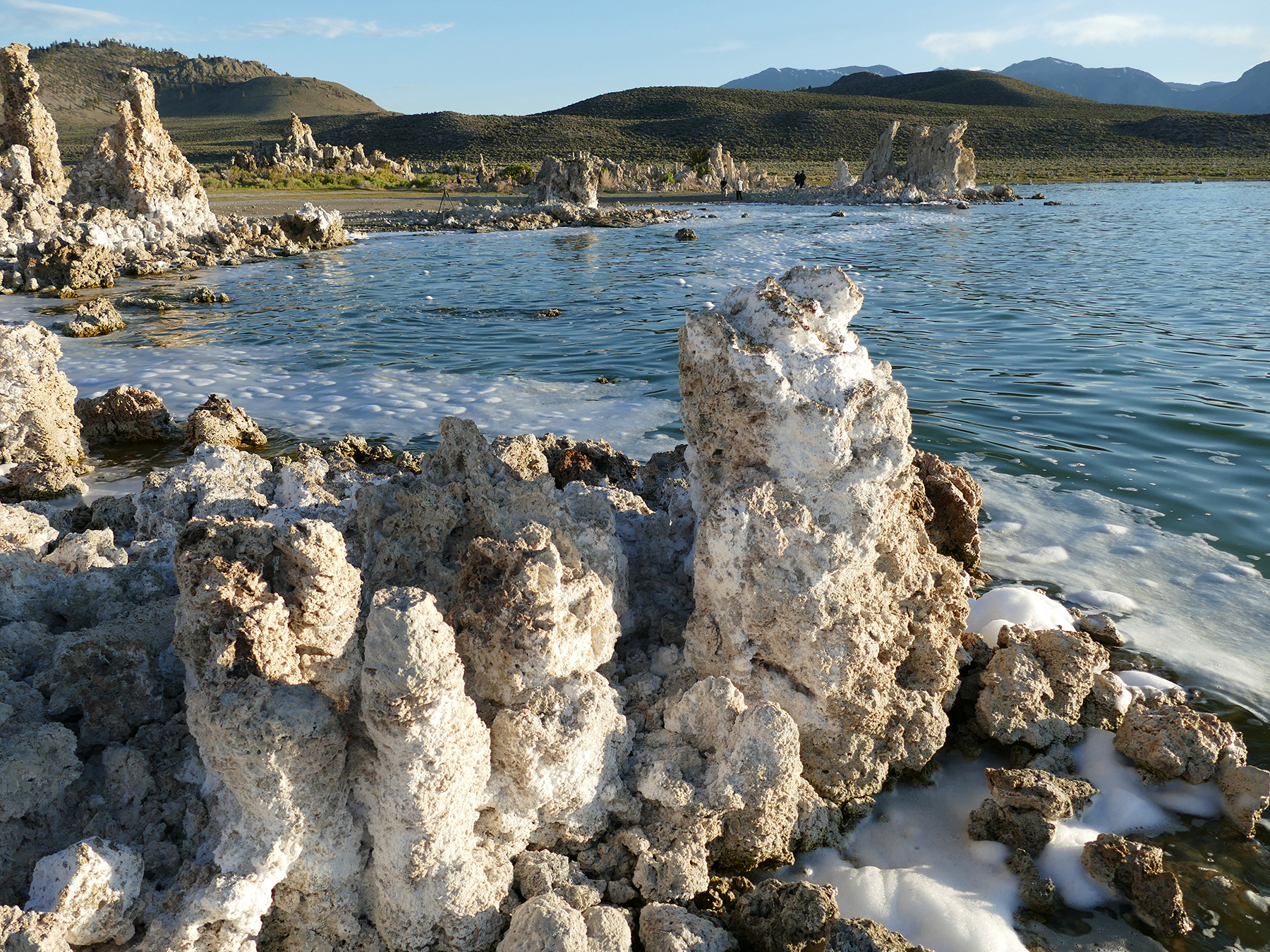
By 1982, the diversion of these feed waters had decreased the elevation of Mono Lake by 45 ft, shrinking the lake’s surface area by nearly one-third and doubling its salinity. Exposure of the lakebed as the waters receded led to significant problems related to air pollution.
In 1994, the California State Water Resources Control Board responded by sharply curtailing the volume of water that the LADWP could divert from the Mono Basin.
Since then, water levels in Mono Lake have risen, though not to the elevation that the SWRCB set as a target to be achieved by 2014. Concerned by the failure of the lake to recover to the target elevation, an environmental advocacy group and a Native American tribe have called on the SWRCB to suspend diversions from the Mono Basin to protect Mono Lake and its wildlife, particularly the large population of California gulls that nest on the lake’s islands.
For its part, the LADWP maintains that Mono Lake is healthy and says that suspending diversions would unnecessarily increase water costs for its customers.
Project components
Like the larger LA Aqueduct, the Mono Basin Extension is completely gravity fed. At its northernmost point, the extension begins with an intake system on Lee Vining Creek, a key tributary of Mono Lake. Here, a portion of the flow is directed into the Lee Vining Conduit, which runs southward for several miles before emptying into the Grant Lake Reservoir.
Originally, the Lee Vining Conduit also received flows from intakes on Parker and Walker creeks. However, since 2021, the LADWP is no longer authorized to divert water from these waterways. The conduit’s design capacity ranges from 300 cfs at the Lee Vining Creek intake to 350 cfs at the section between Parker Creek and Grant Lake Reservoir.
The reservoir was created as part of the project by damming Rush Creek, another tributary of Mono Lake. With a storage capacity of 47,171 acre-ft, Grant Lake Reservoir serves to regulate flows along the Mono Basin Extension. An outlet on Grant Lake Reservoir is used to convey flows into the Grant Lake Conduit, which sends water to the diversion facility known as Mono Gate One. The facility is used to return a portion of flows to Rush Creek downstream of the reservoir and convey the remaining water into the 3 mi long Mono Craters Conduit, which connects to the 11.3 mi long Mono Craters Tunnel. The conduit and tunnel both have a design capacity of 365 cfs.
From the tunnel’s outlet, the water enters the Owens River and flows approximately 30 mi to Crowley Lake, which also was constructed for the project. Upon discharging from Crowley Lake, the Owens River continues southward to the Tinemaha Reservoir before entering the intake of the LA Aqueduct. On its journey to Los Angeles, water in the aqueduct powers multiple hydropower facilities that provide electricity to the city.
Records set
At the time of its construction, the Mono Craters Tunnel was a record-setting affair, as noted in an article titled “The Mono Basin Project” that appeared in the May 1936 issue of Civil Engineering.
“What is believed to be a new world’s record for hard-rock tunnel driving was established at heading No. 1 on April 29, 1935, when 65 ft of tunnel was excavated in 24 hours,” according to the article by H.A. Van Norman, then the chief engineer and general manager of LA’s Bureau of Water Works and Supply, which merged with the city’s Bureau of Power and Light in 1937 to become the LADWP. “This was broken on May 17 and again on May 18, when an advance of 72 ft in 24 hours was made; also on July 15, 1935, 90 ft of progress was made in the same heading in 24 hours.”
Target elevations
Before any diversions occurred within the Mono Basin, Mono Lake had an elevation of approximately 6,417 ft above mean sea level. By the early 1980s, the lake had declined to 6,372 ft, its lowest level ever.
Under the terms of its 1994 determination known as Water Right Decision 1631, or D-1631, the SWRCB established a target elevation for Mono Lake of 6,392 ft, concluding that such a level “appropriately balanced protection of public trust resources and diversions by” the LADWP, according to a Mono Lake fact sheet from the SWRCB.
Based on modeling conducted at the time, the board determined that Mono Lake should reach the target elevation by 2014. However, the highest elevation achieved by the lake after that determination was 6,384 ft, in 2006. With the snowmelt from the heavy winter snows of 2023, Mono Lake’s elevation stood at 6,382.47 ft on July 19, still under the target elevation. (The lake measurements are publicized by the website of the Mono Lake Committee, a nonprofit organization dedicated to protecting and preserving the lake and one of the parties to the litigation that led to the issuance of D-1631.)
D-1631 also set targets for how much water the LADWP may divert from the Mono Basin. These annual targets vary according to the elevation of Mono Lake as measured in early April:
- If below 6,377 ft, or projected to dip below this level, no diversions may occur.
- If between 6,377 and 6,380 ft, the LADWP may divert up to 4,500 acre-ft/year.
- If between 6,380 and 6,391 ft, the LADWP may divert up to 16,000 acre-ft/year.
- If above 6,391 ft, the LADWP may divert all available flows in excess of amounts needed for fishery protection flows, up to 167,800 acre-ft/year.
Before D-1631, the LADWP diverted an average of approximately 70,000 acre-ft/year from the Mono Basin, says Eric Tillemans, P.E., the department’s manager of aqueduct operations and conservation. “D-1631 reduced our exports from the Mono Basin by 85%,” he says.
Suspension sought
In December, the Mono Lake Committee sent a letter to the SWRCB requesting an “emergency regulation” or other action that would suspend the export of water diverted from Rush and Lee Vining creeks and require delivery of that water into Mono Lake until the water body has risen to an elevation of 6,384 ft, according to the Dec. 16 letter. The request was supported by the Mono Lake Kutzadika’a, a Native American tribe that has long lived in the Mono Basin.
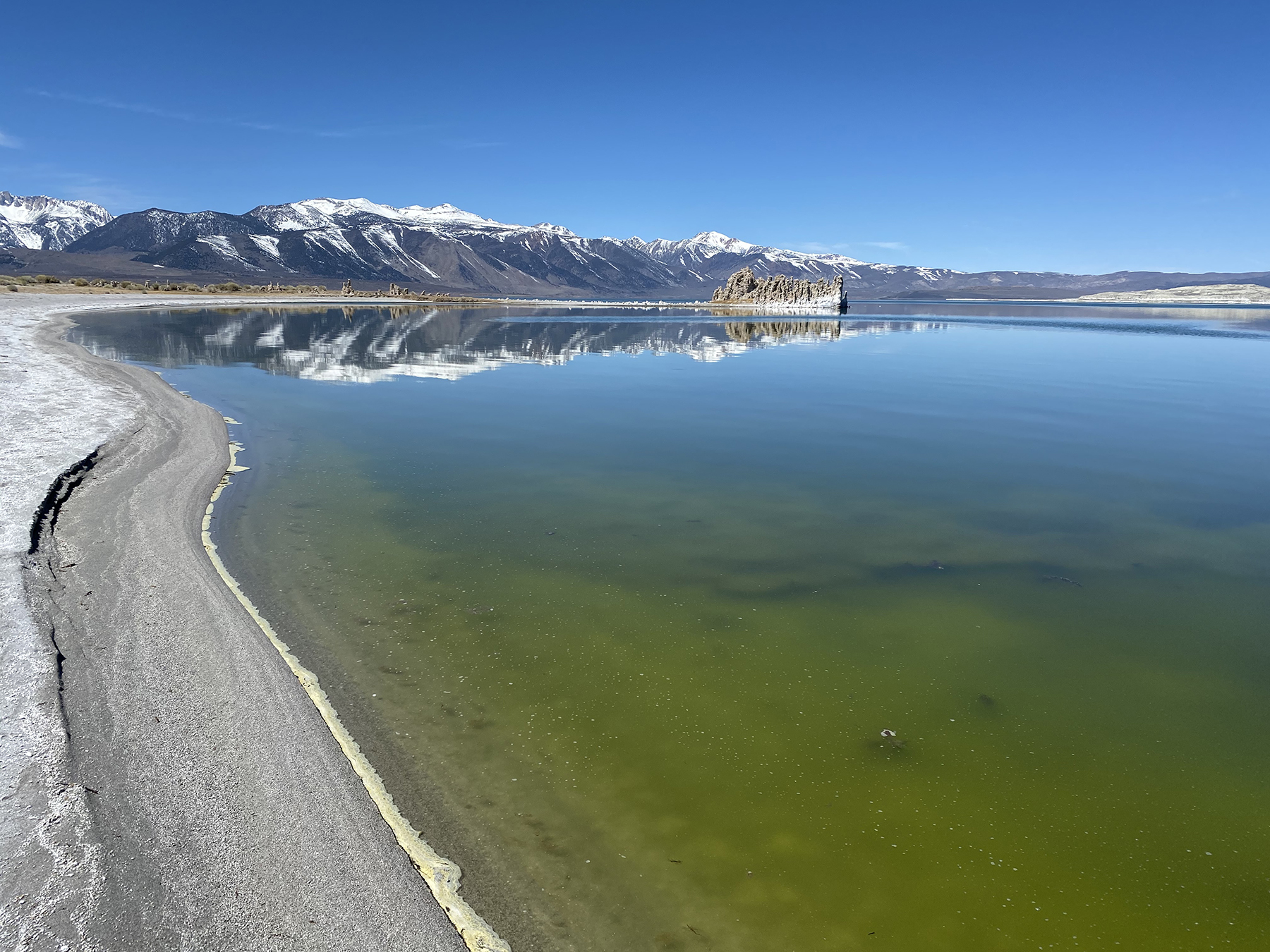
Because of dry conditions throughout much of 2022, Mono Lake had declined to an elevation of 6,378.4 ft by mid-December. The lowered lake level increased the possibility of coyotes gaining access to nesting islands used by the California gull and disrupting one of the largest colonies of the species in the world, according to the Mono Lake Committee. Suspending the LADWP’s export of 4,500 acre-ft/year and allowing that water to enter Mono Lake would protect the gulls and reduce excessive salinity levels in the lake, the committee maintained.
Los Angeles countered that fencing was the solution, not decreasing its diversions. “If potential coyote predation of gulls is the primary concern, there are more effective means for deterring potential coyote predation than prohibiting the City from utilizing its water rights,” according to a Jan. 11 letter from the LADWP to the SWRCB.
The Mono Lake Committee also noted that, under D-1631, the SWRCB was required to hold a hearing to evaluate the diversion limits if the lake did not meet its target elevation of 6,392 ft by 2014, though this deadline was later extended to 2020. “Twenty-eight years after D1631, the lake still has not reached 6,392 feet (above mean sea level),” according to the committee’s Dec. 16 letter. “As a result, a follow-up hearing to reconsider the diversion criteria is required.”
As for the SWRCB, it is “evaluating how best to proceed with the hearing that will determine whether additional actions, such as changes to LADWP’s diversions, are appropriate,” says Sam Boland-Brien, a program manager for the board. “Currently, there is no time frame set for the hearing,” he says.
Bartshe Miller, the Eastern Sierra policy director for the Mono Lake Committee, cites two reasons for why Mono Lake has not reached its target elevation. One is that the original modeling conducted during the development of D-1631 did not adequately account for the decadal variation in precipitation that is common to California. The second is the LADWP’s diversions. “These diversions are absolutely keeping the lake from rising at this point, after 29 years,” he says.
Opposing views
In its defense, the LADWP maintains that Mono Lake and its tributaries are in good condition, in part because of restoration projects that the city has been required to conduct along the creeks. “The Lee Vining, Rush, Walker, and Parker creeks are all healthy streams with thriving ecosystems,” Tillemans says. “Mono Lake is healthy, despite not being at 6,391 feet. It supports large populations of birds, including California gulls and hundreds of thousands of shorebirds that visit the lake at all times of the year.”
While acknowledging that Mono Lake has not risen to the extent anticipated in D-1631, Tillemans says that it has fared better than comparable water bodies. “Mono Lake has gone up,” he says. “When you look at the other terminal saltwater lakes in the western United States, they've all gone down very dramatically.”
Proactive efforts to reduce water consumption among its customers also indicate the LADWP’s commitment to environmental protection, Tillemans says. “The city of Los Angeles made conservation a way of life, using 44% less water than 50 years ago, despite adding a million people to the population,” he says.
From the point of view of the Mono Lake Committee, even more conservation is needed to protect Mono Lake. In its Dec. 16 letter to the SWRCB, the committee maintains that it has sought grant funding “to underwrite direct installation and other water efficiency and supplemental water replacement programs for Los Angeles,” particularly in low-income areas.
Ultimately, Los Angeles can live without the 4,500 acre-ft/year it is currently authorized to divert from the Mono Basin, an amount equating to roughly 1% of the city’s total annual water supply during the past two years, Miller says. “This is a small amount of water, and it is water that is easily offset or replaced in Los Angeles with a little bit of effort.”
Tillemans disagrees. Current diversion volumes from the Mono Basin are “enough water to serve as many as 200,000 Angelenos every year,” he says. “Approximately 50% of the Los Angeles ratepayers live in disadvantaged communities, and any supplies that the city of LA loses through the Los Angeles Aqueduct system means that those ratepayers are going to have to pay more for their water.”
Meanwhile, the diverted water “generates enough hydropower for 80,000-90,000 homes,” Tillemans says. “That hydropower is green energy, which is very important, especially today.”