By Sarah Derouin, Ph.D.
Sea levels have been marching higher for the past century, and rates have accelerated in the past few decades. From 1993 to 2014, average sea level rose 2.6 in., (about an eighth of an inch per year), and it continues to rise at about that same pace.
Waterfront cities are facing increasing threats from rising waters, including flooding and coastal erosion. By the year 2100, scientists estimate that about a billion people around the world will be at risk of hazards from sea level rise. And with the continued acceleration of sea level rise, current hazards could increase by two to three orders of magnitude.
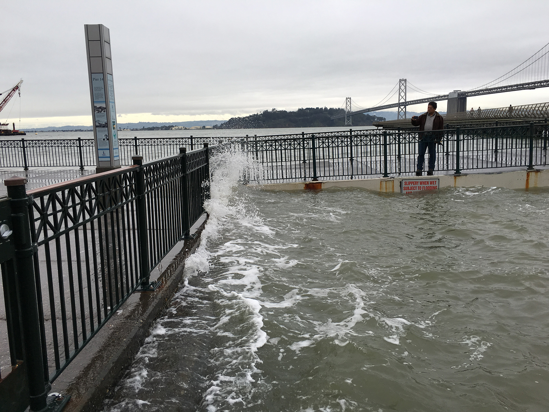
Smart adaptation of civil engineering can help mitigate the risk to coastal communities. But for these efforts to be effective, engineers and city managers have to know where sea level rise effects will happen and by how much. But having good information is just the start — communities also need robust plans that will take them through the next century and beyond.
Recent papers in the journal Earth’s Future showcase new research on more accurate elevation measurements for coastal land at risk from rising sea levels, what some communities have planned for expected inundation, and what sort of land reclamation is taking place around the world as new land is created off existing coastlines.
Understanding where impacts will happen
There are two main factors that affect a coastal community’s flood risk: the amount of sea level rise it experiences and the elevation of its coastal land.
“When we think about sea level rise, globally, there are two main factors that cause sea level to rise. One is melting ice that is currently on land — so glaciers and big ice sheets like Antarctica and Greenland. The other thing that causes sea level rise is that when water heats up, it expands,” explains Andra Garner, Ph.D., a climate scientist at Rowan University in Glassboro, New Jersey.
But for individual cities, local sea level rise can be affected by a few other factors that are specific to their locations. “Here in New Jersey, during the last ice age, we were on the edge of a big ice sheet. That ice sheet sitting inland caused the land to rise up, and now that that big ice sheet is gone, we're sinking back down. So our sea levels are rising faster than average here,” explains Garner.
Most cities and communities get their sea level rise numbers from an international consortium of scientists known as the Intergovernmental Panel on Climate Change. The IPCC just published its Sixth Assessment Report, a comprehensive look at climate change around the world. This includes sea level rise projections for 2100 and the centuries beyond.
The IPCC estimates sea level rise values as a range, depending on the uncertainties in natural and human behavior over the next century. “We have global projections for really low emissions, assuming we take drastic action to limit climate change, or really high emissions, where we do nothing,” explains Garner.
Estimating how far the water will rise is one factor in mitigating coastal flooding; the other is land elevation. While the elevation of coastal areas may seem like a static measurement, the Earth is an ever-changing entity. For example, land can subside over time as groundwater or natural resources are removed, such as is happening in California’s Central Valley. The elevation of land relative to sea level can also change because of rebounding forces when enormous ice sheets elsewhere melt, such as Garner explains is happening in New Jersey, or during reclamation projects where new land is created.
Because of these changes, monitoring coastal areas over time is an important part of managing flooding risks. In the past, most coastal elevations were measured with radar images collected by Earth observation satellites, creating a global digital elevation model. However, radar data has limitations — it can’t see through thick vegetation canopies or differentiate built-up areas from natural ground surfaces. Radar measurements reflect off such surfaces, creating inflated ground elevations.
To alleviate this problem, researchers turned to new Earth observation satellites that carry lidar sensors. “Lidar is able to penetrate the canopy and improves surface elevation estimates at an accuracy of about 0.5 m at 1 km spatial resolution,” says Ronald Vernimmen, Ph.D., a researcher in the Netherlands and director at Data for Sustainability.
In a recent paper, “New LiDAR-Based Elevation Model Shows Greatest Increase in Global Coastal Exposure to Flooding to Be Caused by Early-Stage Sea-Level Rise,” Vernimmen and co-author Aljosja Hooijer used this newly available data and created a lowland elevation model for coastlines. Previous studies that used radar elevations noted that flooding rates would increase as sea levels rose. However, the new lidar models painted a very different picture of flooding.
“We find that the greatest increase in coastal areas below mean sea level will occur in the early stages of sea level rise, contrary to earlier assessments,” Vernimmen says. Flooding not only occurs faster in the beginning stages of sea level rise, but the researchers also found that in one-third of countries, most of the increase will occur during the first meter of sea level rise.
“Our findings, therefore, indicate that the time to adapt to rising seas in many areas is indeed shorter than would appear from previous elevation models,” he says.
Do US cities have a plan for sea level rise?
“The science of sea level rise is constantly evolving, and of course, one of the reasons that we want to understand sea level is so that we can plan for it in our coastal communities,” says Garner. “One of the questions we had is how well is the latest science making its way out of the scientific realm in our peer-reviewed journal articles and into local assessment reports that ideally are developed by and for local stakeholders, local decision-makers, and policymakers.”
In their study, “Evaluating Knowledge Gaps in Sea-Level Rise Assessments From the United States,” Garner and her co-authors, including colleagues and students, tracked down what sort of assessments coastal states or cities had for dealing with sea level rise. In particular, the researchers looked for the year reports were published, how far into the future they were planning, and if communities used a range of sea level rise to capture uncertainty.
They divided the country into three sections — U.S. Northeast, West, and South — and compared the local reports to the latest IPCC report. “We found that over half of the locations in the U.S. that we looked at actually are underestimating future sea level rise compared to the high-end projections from the IPCC report,” Garner says.
Garner added that many places did not have long-term projections beyond the end of the century. “In the U.S. Northeast and the U.S. West, both at least had several reports that do plan for the year 2150 or 2200, but the U.S. South didn't have any long-term projections that go beyond the year 2100,” Garner says. “We view that as a potentially really big knowledge gap in that region to not have that longer-term look at what sea level rise might do.”
In addition to shorter sea level projections, many reports in the U.S. South only used one value for sea level rise. “Having just that one number, for us as human beings, is very appealing — we’d like to just have one number to plan for and be done with it,” says Garner. “The unfortunate reality is that sea level change just isn’t that certain.”
She explains that one number creates a simpler plan for building guidelines, but that approach might also be underestimating future flooding challenges. “We could have more sea level rise than they’re planning for, which then becomes really costly for trying to retrofit infrastructure.” In fact, recent research has suggested that recent sea level rise may be even higher than previously thought in the U.S. South.
Reviewing the latest IPCC sea level projections can be important for future building and infrastructure as well. For example, Garner notes that a park with lots of green space can likely handle some flooding, but “if it’s a power station or a new hospital, then it’s worth doing a broader search beyond the local projections and see what some of the higher projections from IPCC are looking like.”
She says if communities find they have underestimated or outdated sea level estimates, they can easily update their data with a new, free sea level portal tool from NASA. The interactive tool shows the latest sea level rise projections from the IPCC report projected for 2100 and far beyond.
Where is land reclamation taking place?
For areas affected by sea level rise, engineering can help bolster their coastlines and infrastructure. Activities such as seawall construction or infilling wetlands or shallow seas are reclamation efforts that can protect or even create coastal lands.
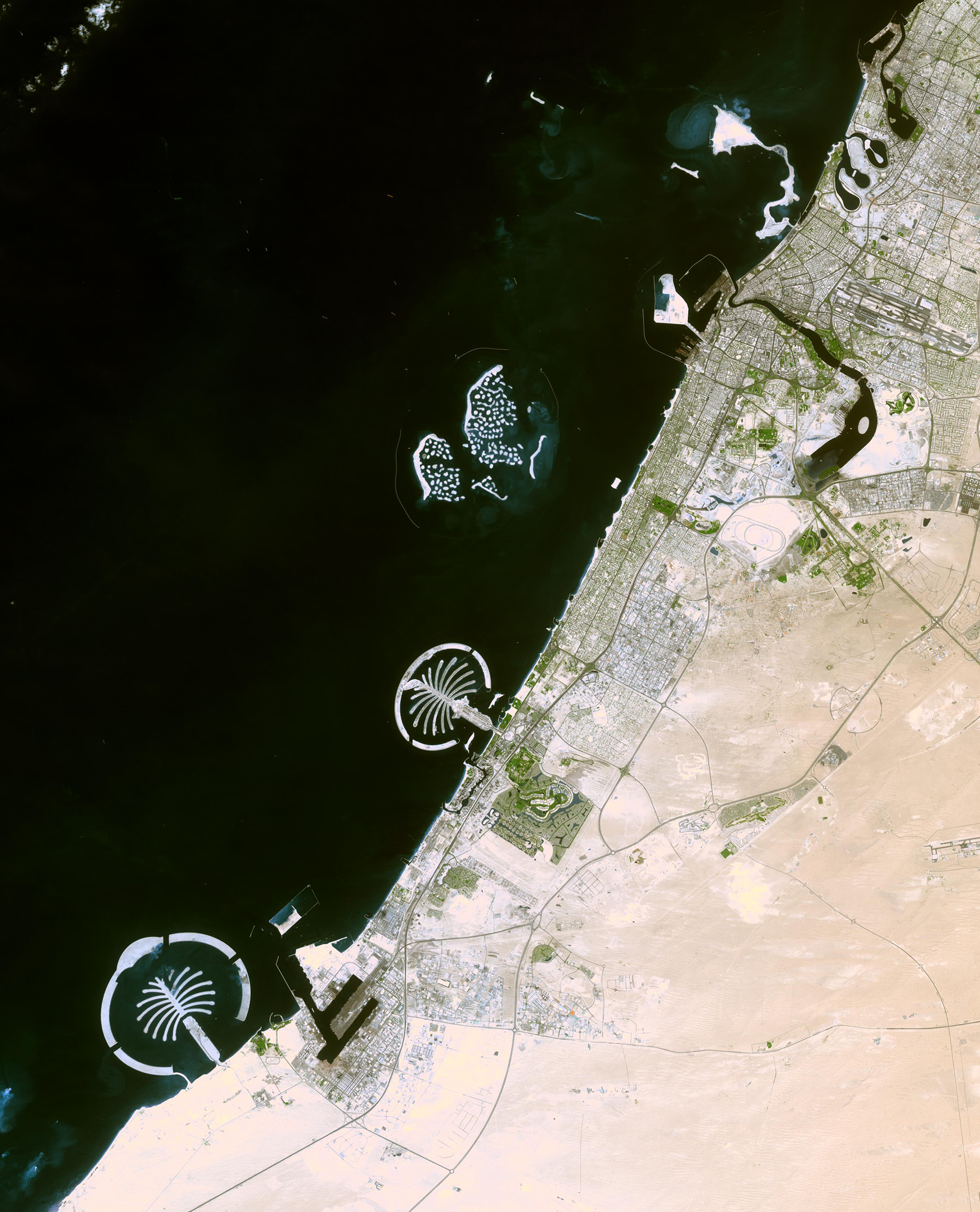
“Land reclamation is not something new. Cities have been building out since the 19th century and even before — the Netherlands is the best example,” says Dhritiraj Sengupta, Ph.D., a geographer at the University of Southampton and co-author of a new study, “Mapping 21st Century Global Coastal Land Reclamation.”
Sengupta notes that over the past century, regions in the U.S. like the San Francisco Bay area and the New York metropolitan area have built out, as have numerous cities in the United Kingdom. As sea levels rise, more cities and infrastructure will be at risk.
Recent technological advancements in engineering have allowed megacities in Southeast Asia and West Africa to expand through land reclamation, Sengupta says. “I was interested in the environmental impact of land reclamation,” he says. “To assess that correctly, I need to understand the way construction happens.”
Sengupta and his colleagues used NASA and European Space Agency satellite imagery and cloud computing technology to monitor more than 100 cities with populations of more than 1 million over a 20-year time span. The researchers used the imagery and algorithms to detect the changes from land reclamation activities that were happening.
“There is this hot spot of Southeast Asia, where land reclamation in coastal cities is kicking in,” he says, adding that Western Africa is a second huge reclamation effort. On a global scale, the researchers found that 70% of reclaimed land was in areas facing potentially extreme sea level rise.
Sengupta points out that building these sites is one thing, but maintaining new land in coastal environments requires continual resources. “One common thing which connects all these construction sites is sand,” Sengupta says. “If you're planning to build land and maintain that, with future sea level rise and climate change, you need more sand.”
He points out that sand is a natural yet nonrenewable resource. And as sea level rises, more sand will need to be added to reclaimed land to fight off the rising waters. “The land will subside, but you need more and more sand to kind of fill in and then keep that level up. Exactly how sustainable is that? That's the question.”
Communication for mitigating sea level rise
The researchers agree that good communication — including the latest scientific research and mitigation ideas — is crucial for protecting communities from sea level rise. “I think that communication is super important” between scientists and stakeholders, says Sengupta. “It's important that we have this interaction and ask questions: Do we actually need this? Is it sustainable, keeping in mind the raw materials?”
During these conversations, it’s important to look forward. “I think when you read the study, you might think, ‘Oh my gosh — we’re really failing here,’” Garner says. “I like to point out that I think that might be true in some places. But there are other places that were definitely doing a great job.” She notes that those success stories can provide a road map for communities nearby.
This article first appeared in Civil Engineering Online.